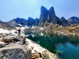
Wind River Range - September 2022

marquiri

Member
Joined
Jan 15, 2018
Messages
87
Hello all,

I'm in the process of planning a trip into the Winds next fall. This will be our first trip into the Winds. We've previously done extended trips in Yellowstone, the Tetons, and the Bob.

I reached out to @Bob for advice given our group's constraints, and he was kind enough to share a few options with me. I think we've settled on a loop out of the Scab Creek trailhead, over Rainbow Pass, down into Bonneville Basin, and back to the trailhead. It's the Lee Lake route that @Bob posted a trip report on last year (https://backcountrypost.com/threads/wind-rivers-lee-lake-loop.9966/).

It's only 33 miles or so, but we'll probably take our time and spend seven days out. Right now I'm looking at camping at Lightning Lakes, Dream Lake, two nights at Lee Lake (with a day trip either up to Kagevah Peak/Photo Pass or Noel Lake), Lake 10521, and the last night at South Fork Lake.

All of my planning thus far is based on @Bob's advice and research in Beyond Trails and on the internet. Just wondering if anyone has any experience in this region of the Winds who would like to share information on campsites or anything else that comes to mind. Thanks everyone.
 
Sounds like a great itinerary. I haven't been to that specific area yet but it's on my bucket list. My only advice is to lower your expectations for the first/last day, because they're always disappointing in the winds, but once you get those miles behind you, it's paradise! (So you're smart to take more time back there). With that much time, you might also want to consider a larger loop or one way route (you can pay for a shuttle) incorporating the east fork (desolation valley) area to the south, or swing by Europe canyon and such to the NW. There are tons of great options. If you don't have the Pallister book yet, go buy it!
 
Last edited:
I do have the Pallister book. What a great resource. We're limiting the daily miles/number of days based on the wishes of members of our group. We have 4, and not everyone likes long days/long trips. I like to be out for 10 days, but at this point it looks like all we will do is 7. The miles per day is another sticking point.

It's okay though. It is nice to be able to spend a little more time in camp in the morning and not have to worry about hiking in the dark on the back end. I'd love to get into Europe Canyon, but I guess that will have to wait for a future trip. I really appreciate the feedback.
 
Funny how a pass can acquire two different names when there is not an official one labeled on maps. I see what's been called Bonneville Pass here referred to as Sentry Pass by a number of others in other write ups. Either way...fantastic choice! I developed a new crush going through there last summer. Her name is Donna...

1642279583232.png
 
awesome! despite being a longtime SLC resident I've only gotten into the Winds once, a few years ago in July or maybe early August, and the mosquitoes were so bad my son and I bailed after one night and spent the rest of our time in the Uintas :). I'm looking forward to a September trip at some point!
 
@WasatchWill, to add to the confusion, Nancy Pallister refers to it as 11865-11925 Col. Funny, I just started watching your high route series yesterday before I saw that you had replied.
 
I've always used Bonneville Pass, the next one east is Shelia Pass, the one going south into the east fork is Pain in the Ass pass. .... Called them that since my high route trip we did in 2009 from Sweetwater to Green River.....
 
@Bob, can you weigh in on the side trip up to Kagevah Peak? It doesn't look like it would be terribly difficult. From my contour map it looks a lot steeper getting up to Kagevah Pass.
 
I've always used Bonneville Pass, the next one east is Shelia Pass, the one going south into the east fork is Pain in the Ass pass. .... Called them that since my high route trip we did in 2009 from Sweetwater to Green River.....
Hahaha! I concur. Much more fitting than Raid Pass or Raid Peak Pass. But still not as brutal as Camp Lake to Titcomb via Alpine Lakes and Indian Pass. That kicked my keister, hardest most physically grueling day of backpacking in my life.
 
@WasatchWill,

Any advice on what you called Bonneville Pass? We'll be coming up the north (west) side and down the south (east), so the opposite of what you did.

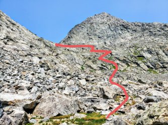
@Bob told me the side going down to bonneville canyon (in his photos) looks worse than is, there are walk down angled ledges you follow down on the right side by the green, nothing to steep or scrambling. You seemed pretty gassed once you got down, but I'm wondering if that was due to it being your second pass of the day. I'm sure Pain in the Ass Pass wore you down.
 
This is a great loop. Sounds like you have good ideas for camps based on mileage limits. I tend to push entry/exit days to spend as much time as possible near/above tree line. Dream L day 1 isn't too bad. Plenty of sites all around. Went for some nice sites on a knoll with trees just west of the trail in 2020 (just after the massive wind storm) Winds2020. Last year, Bob picked a really nice site closer to the lake so he could out-fish me 10:1.

With an extra day might have extended loop to go up Middle Fk Lake and then down to Lee. Europe Canyon is supposed to be very scenic. Definitely on my list for future trips. Pic is Bob and I talking about routes in that direction.

You can't go wrong. It's the Winds.

Busy planning my Sept trip as well. 4 weeks this year.
 

Attachments

  • IMG_1241.jpg
    IMG_1241.jpg
    387.3 KB · Views: 25
  • Like
Reactions: Bob
WW That would be tough . Long day
 
Have not been up to the peak...... I dont do peaks as a standalone, i see no point in it. ... Unless they are in the way to somewhere, which isn't often But what I hear is it a pretty easy scramble. May look on summit post.
 
@WasatchWill,

Any advice on what you called Bonneville Pass? We'll be coming up the north (west) side and down the south (east), so the opposite of what you did.

@Bob told me the side going down to bonneville canyon (in his photos) looks worse than is, there are walk down angled ledges you follow down on the right side by the green, nothing to steep or scrambling. You seemed pretty gassed once you got down, but I'm wondering if that was due to it being your second pass of the day. I'm sure Pain in the Ass Pass wore you down.
Let's just say that coming down that side of Bonneville in the opposite manner was pretty tedious. Lots of talus and scree to navigate through and around when you can. It was a really hot day when we did it, then again most days were and yes, having just done Raid/PIA pass just before that with only a lunch break in between didn't help matters. I was thankful to have done the short way up from the south though. Less elevation to regain that way, especially after coming over the Raid/PIA pass just prior. As you go down it to drop down Bonneville Lakes, just lean leftward (what was rightward for us) as you go down and as you mentioned, you'll find a bunch of easy rocky ramps mixed up with some soft grassy benches to step down. It's really not bad at all. If you find yourself leaning to your right it's much more cliffy that way so avoid that. At least that's how I remember it.

See image here of that south side and how we approached it...

20210725_133448.jpg

The way up from Lee Lake is a more gradual grade. Just really long and tedious way up and as already mentioned, lots of scree and talus, but Donna Lake makes for a breathtaking gorgious spot to pull over and rest up before you make the final push up and over.
 
Must have spent to much time in the Winds ... I thought Bonneville Pass was one of the easiest to get up and down. ..
 
@WasatchWill:

Thanks so much for the route description over the pass. It matches up with what @Bob described to me. I saw in another video that it looks like there is quite a bit of knee high brush that you have to walk through if you are too low walking between Lee Lake and the pass. I think I read somewhere that you're better off not dropping all the way down (in the direction that you passed through) if you want to avoid that brush. Does that sound right?
 
There is a fisherman use trail
around the eastern side of Lee lake to a good camp site on the end away from middlefork lk.... But it's in the shadow early. So brush is no problem
 
@Bob

Have you been up to Bewmark Lake/Photo Pass? Just trying to decide whether it would be a worthwhile excursion on a zero day. I'd consider camping up by Bewmark Lake, but I'm not sure anyone will want to lug their packs up the face of the wall north of Middle Fork Lake at the end of the day.

Would you say the camping is better closer to Lee Lake (I believe that's where you stopped for night 2 on your 3 night loop) or up by Middle Fork Lake?
Lee lake ... Less people, fantastic views. Good campsite at outlet on the east side in the small hill between kee and the small pond. There is a trail to Newmark up the draw on the west side by middlefork. Use trails around middlefork as well. About 3 m one way from Lee to bewmark. Another 1.5m one-way to kagevah peak. Or another 1.5m to photo pass. I wouldn't dayhike from Lee. Another real nice lake is Halls, just up from middlefork. Also Donna and Noel nice. Lee has good fishing for big brook trout.
 
Back
Top