Slickrock above Upper Buckskin Gulch?

powderglut

In search of Fresh
Joined
Oct 17, 2012
Messages
367
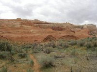
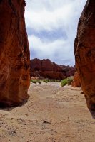
The last time we were camped at Stateline CG on House Rock Valley Rd, we did the upper section of Buckskin to Wire Pass. Before you enter the first narrows or slots, there seems to be an amazing amount of brain and slickrock. I told the crew, that I'd really love to come back and check out all that stuff in the first 3 miles to the north or east.
Anyone put in any time in this area? It looks amazing and seems like know one talks about this particular area. Looks like there could be some great formations on some of the upper slickrock cliffs. I'm sure we'll have it on our list this spring if we camp down there. Any info would be appreciated.

...yes, I've been there several times. It's a very nice area w/ a lot to explore.
If you need some beta please feel free. :)

Gesendet von meinem ViperXed HOX |2.7.1| mit Tapatalk 2
 
...yes, I've been there several times. It's a very nice area w/ a lot to explore.
If you need some beta please feel free. :)

Gesendet von meinem ViperXed HOX |2.7.1| mit Tapatalk 2
Thanks Michael, I knew someone had to have marched around this place. I will be in touch. This area's been calling me for a while.
 
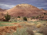
Michael, these are the main areas we were thinking. The brain rock mound and then on top of the cliffs. Is this the area you are familiar with? It looks like an amazing place to explore for a day.

This was one of the areas that I wanted to checkout. It was hard to walk past it that day.IMGP0284.JPG

Same with this area up near the top.

IMGP2758.JPG

I will gladly take any beta you have of this area. I think it has great potential.
Thanks
 
Powderglut, yes it's the area where we talk.
That's an really amazing place to explore for one or several days.
Around the brain rock mound are many pattern, ribbons, lace rocks, brain rocks,buttes, etc.
If you hike upwards in direction to the horn of The Dive, you'll find many pools, a handmade stock pond dam and spectacular views to Mollies Nipple, Castle Rock, the whole Top Rock and Coyote Buttes.
To explore all of them, will be an long long day, or you camp there neck of the woods.
A shorter way is, drive (4WD) from US 89 to BLM road 750 and later 3 mi on the old jeep trail. From here it's a short hike to the rim and down to the overlook and pond.
I never has done that route, I'm on a RV, but I know, that's possible.

Here is a view from the top of brain rock mound to the north (6.6 mb for a closer view).

An other view from the opposite (16 mb for a closer view).

A view from Top Rock arch area. On the picture middle left, where the two-story streaks of desert varnish are located (on the top I was), this was my last point (4.8 mb for a closer view).

My old 'rough' topo-maps are here and there.

If you or anyone needs waypoints to saving your time, please PM me.

My newest beta is that here behind this point.

Gap_bcp.jpg

I gathered it from a hiking-mate this year, but I never has seen it alive.

Maybe you or 'eagle eye' Randy could make better pictures. I'm glad to see your results.
Hope, I could help. Enjoy your trip and have a lot of fun.
 
Yah Michael, thank you. You reassured me this is a great place. I knew you could come in from the top. I think we will do this access from the bottom this time. I'm sure we'll base at Stateline CG. So easier to just hike in from there. After we climb up to the ridge I may try the top route another day. This place looks great. Excellent Beta!
 
Hi Michael,

Like you, I love Edmaier's secret area. You have done a great job with your topo maps and congratulations to have found this panel that I missed (that's a pity as I am found of rock art).

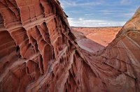
Powderglut, near the summit of that big slickrock hill that you have photographed, you can look for that small but nice "Wave style" feature :

Edmaier Secret - Wave at the summit 1 ME.jpg
 
Yah Michael, thank you. You reassured me this is a great place. I knew you could come in from the top. I think we will do this access from the bottom this time. I'm sure we'll base at Stateline CG. So easier to just hike in from there. After we climb up to the ridge I may try the top route another day. This place looks great. Excellent Beta!

Powderglut, that a good plan, and the newly remodeled Stateline CG is a really nice one to setup as base. I love this CG too.We have had our RV camp near Buckskin TH.
I saw really nice camp spots westernly of Buckskin.
 
Hi Michael,

Like you, I love Edmaier's secret area. You have done a great job with your topo maps and congratulations to have found this panel that I missed (that's a pity as I am found of rock art).

Hi Phillipe,
Thank you.
Unfortunately! I've never found this panel by myself. :(
I only received the info about it, a couple of days ago.
But this is one point to revisiting this wonderful area again - maybe in 2014. Our tour plan for 2013 is ready. We only needs a couple of 'Plan B', if the weather isn't with us.
Btw, a very nice picture, Phillipe! I also found little eroded rocks - far similar to the sand roses of the western Sahara, nice to see.
 
Back
Top