Sawtooth backpacking advice

IceChip

Member
Joined
Apr 27, 2017
Messages
6
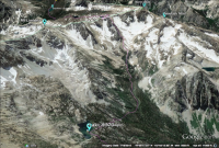
Hi, I'm planning a trip to the Sawtooth Mountains for mid September this year. I have a few guidebooks and am using Google Earth to scout stuff. I've been looking into route options and have read through a bunch of trip reports on here and found some great information. The one thing I haven't found, however, is any instance of someone crossing over the ridge to the East of Baron Peak. I'm not sure why, but I've become fascinated with the possibility of after following the trail South from Sawtooth Lake, heading basically straight South (after side trips to check out those lakes - In Purple) from the trail (478 - in green) where it turns West to follow the North Fork of Baron Creek towards Grandjean. The plan would be to keep heading straight South through the Valley, aiming for the slope that leads up to the (more or less) lowest point in the ridge to the East of Baron Peak. Then I would descend towards Stephen's Lake, Braxon Lake, then aim to join up with trail 101.

(Facing due South)
upload_2017-4-27_19-35-49.png


The only part I'm worried about is getting over that ridge to the East of Baron Peak. Does anyone have any experience with this area or advice about this? My alternative option is just following the trail down the North Fork of Baron Creek and then up Trail 101 along Baron Creek to Baron Lakes.

Any help is greatly appreciated! Thanks
 

Attachments

  • upload_2017-4-27_19-31-29.png
    upload_2017-4-27_19-31-29.png
    1 MB · Views: 22
here are some pictures also looking due South at your ridge.
sawtoothsseptember2013 284.JPG

DSCF2182.JPG

DSCF2209.JPG


the first image is from the first week of october. the other two are from the first week of september. as you can see there is a chance of some snow. i've never gone over the ridge. it looks doable. but going down through the valley bottom looks like a real hassle. and going around it also looks like a hassle. i would guess that getting up and over the divide would be easier than actually getting to it. i have had some great off trail experiences in the Sawtooths, but also experienced some terrible bushwhacking and side hilling that i wouldn't care to repeat. i would not recommend your planned route. but i'm not saying i wouldn't attempt it. also. i think it's unlikely that following the ridge crest to the top of the divide is a real possibility, as you have drawn on your map. i would imagine that you would have to go up one of the scree/talus slopes to a saddle.

i can tell you that the walk down the North Fork, and up Baron Creek is not a bad hike.
 
Wow @Ben thanks for the pictures and the advice. I'm thinking I'll plan some extra time into my trip for an attempt, though fully expecting a high chance of abandonment and taking the North Fork/Baron Creek instead. I just can't stop wanting to get over that divide for whatever reason.

That being said, can you go into a little more detail which route you'd take if you were actually attempting this? Following the ridge crest up just seemed like the least steep route to get up there but I'm no expert in this type of terrain.

Also, just curious, do you know exactly what the POV is for those shots?
 
those photos are taken from the trail South of Sawtooth Lake. the first and last are from where the trail begins to descend in to the valley of the North Fork Baron Creek. the middle image is taken from South of Sawtooth Lake, but North of the tarns near it. all of them are nearly the same view.
if i were going over the divide i would guess the easiest climb would be to the saddle just left of the smaller, rounder hump right in the center of the third image.
 
Back
Top