Potential Middle Basin - Naturalist Basin loop

WasatchWill

Ready For More
.
Joined
Jul 23, 2013
Messages
1,657
I was looking at taking a little trip into Naturalist Basin in a couple of weeks and was originally just going to stay one night. Now I'm thinking I'd like to go up the ridge south of Hayden and drop down into Middle Basin first for a night, then head cross country south east to the ridge that runs east of Mount Agassiz to get up and over into Naturalist Basin for a night. I'm familiar with the first ridge, though I haven't actually ascended or descended it from the MLH side. I've only done it as a day hike when spending some time up around Ryder Lake. I have a few questions...

1. Would that second ridge crossing, between Middle Basin and Naturalist Basin, be anything too spicy? Topographically, it looks no worse than the first ridge between MLH and Middle Basin. In fact, it looks like it'd be quite a bit easier. From the looks of things, the steepest slope would be the one descending down into Middle Basin, which is the one I'm familiar with. Can anyone confirm?

2. Could I expect the snow to be cleared off those ridges in 2 weeks, or would it be better to hold off until July? I'd like to experience the basins when they're nice and green, blooming with flowers, flowing with waterfalls, while still catching some patches of snow on the higher peaks surrounding the area.

Here's the route I'm considering. Red was my original plan. Green is my latter addition in an effort to include Middle Basin in the trip.
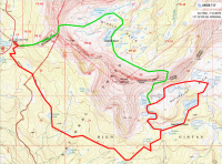
Jun 1, 2015, 6:19:55 PM.png

EDIT: I'm also open to doing it the opposite way (Naturalist first, then Middle), which might actually be a better way to do it if I'm right about the steepest grade occurring on the slope heading westward and upward from Middle Basin.
 
Last edited:
@Dan did it once. His trip report is missing all the photos, but you can still read his description on his website, here: http://www.danransom.com/2011/07/middle-basin/. Excerpt from that part is below.
I set up a minimal camp just beyond Ryder for the night, hoping to catch a nice sunset and sunrise, but yet again, no clouds. Quickly snapped a few photos and headed off for the next saddle while the snow was still hard. My original plan was to ascend the gully closest to Spread Eagle Peak, but the snow looked a little more dicey and steep, so I opted for the saddle closer to Agassiz. It was probably a good decision, but in order to get to Spread Eagle, I had to scramble over a small little bump in the ridge. Turns out to be rather tedious boulder hopping, and added another 45 minutes or an hour to the summit. No big deal, but probably not ideal, unless Agassiz is the intended target.

From the saddle, it looks like a quick and easy walk up to the summit. There is nothing difficult about it, but the walk was way longer than I expected. Figured on an hour or two tops, but I think I returned to my pack after closer to 3 hours, and a handful of false summits later. S.E. is a very cool summit though, and the views to the east are pretty killer. Not really a noteworthy summit, and I’m not sure how frequently it is visited, but it was pretty reasonable. I next turned my attention to Agassiz, but I was starting to feel a little deflated, and some clouds (finally!) were building up over the summit. I made it to the last saddle before the final 1000 foot climb, and rested for awhile. The clouds got thicker, and the lure of being back to the trailhead in a few hours proved irresistible. So I bailed on the last peak of the trip, and headed down the snow patch to a half-frozen Blue Lake, tried to find the trail amidst the snow, and eventually made my way back to the Highline.

In my experience, he tends to play difficulties down, so take that for what it's worth. Doing it on snow with good traction and an axe would probably be a lot easier than on rocks though.

This is the pass closer to Spread Eagle. It definitely looks like there's a chute, but dang that looks narrow and right at the angle of repose.
07middlebasin063.jpg

And you can kind of see a little of the pass closer to Agassiz on the right side of this photo with the Spread Eagle Pass still visible on the left. The rest of it is pretty much solid walls.
07middlebasin064.jpg

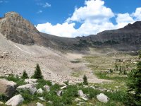
As for the pass into Middle Basin from the trailhead, I've heard of plenty of folks doing it. This is what the pass looks like on the Middle Basin side.
07middlebasin133.jpg
 
@Dan did it once. His trip report is missing all the photos, but you can still read his description on his website, here: http://www.danransom.com/2011/07/middle-basin/. Excerpt from that part is below.

Thanks Nick. This is good info. Can't believe there was still ice in the lakes up there at the end of July for @Dan, but then that was the huge snow year too if I remember right. Still, it's sounding like an attempt of this route would be better attempted in July or August since I don't have any ice axe nor the practice with one. That chute up closer to Agassiz is definitely what I had in mind, but man, those pics of yours do make it look a bit more challenging than the map makes it look. I was just going through my own pics from the Ryder Lake trip I took a couple years ago to see if I got that area on any shots, but nope.

If nothing else, I can still go into Naturalist Basin later this month, day hike that ridge up by Agassiz if it's not too overwhelmed with snow still, and have a look down into Middle Basin and get a feel for what descent would look like. Then, if it looks comfortable enough for me, see if I can't make a return to do the whole loop in July or early August when the area is in its prime for summer beauty. Still, having done Kings Peak at the end of June a couple years ago, only having to traverse a few short snow fields, I was hoping I could have the same kind of luck with the high slopes of the western end this June.

As for the pass into Middle Basin from the trailhead, I've heard of plenty of folks doing it. This is what the pass looks like on the Middle Basin side.
View attachment 30812
Yep! I'm familiar with this one. In fact, my avatar pic was taken up on top of that one. Bald Mountain sits to the right of my in the background.:)
 
http://www.americansouthwest.net/utah/uinta-mountains/naturalist-basin.html

There's someone who took a bunch of pictures from that ridge. I don't know exactly what route he planned, but he got up there from the Naturalist side, near Spread Eagle.

The map linked below is more about getting to the summits of either Agassiz or Spread-eagle, but it also shows a way up to the ridge from the Naturalist side too.

http://images.summitpost.org/original/108259.JPG

About snow; try calling the ranger's office. They can give you pretty up to date snow conditions.
 
Last edited:
Back
Top