Plan B to High Uintas Backpacking

DrNed

The mountains are calling and I must go
Joined
Mar 31, 2013
Messages
1,026
I'm leading a group of teenagers on a a 5 night backpacking trip from Hayden Pass trailhead
to West Fork Blacks Fork from July 15 to July 20.

While it looks like the snow is melting fast, I'm concerned about how much could still be there
in 18 days. I'll do a reconnaissance the weekend before to get a first hand look at Dead Horse Pass,
but I need to start considering a Plan B.

Any suggestions for a 35-55 mile backpacking that won't be hindered by snow the week of July 15?

Thanks
 
The trick will be staying off the passes I'm guessing. Maybe head up to the Granddaddy Lakes area from the Upper Stillwater Trailhead. If Rocky Sea Pass is doable head over to the Rock Creek Drainage and explore there. If Rocky Sea Pass is a no-go, head back down Fish Creek to the Rock Creek trail heading up in to the Rock Creek Drainage. Head of Rock Creek trail is beautiful. Head for the Ledge Lake Trail from the Highline, and head south then up into the Squaw Lake area, Then up to Cleveland Pass but rather than go over the pass head south towards Clements Lake, circling Brown Duck Mountain. Hook back up with the Ottoson Trail and back on Rock Creek Trail to the original trail head. Just a thought.
 
The trick will be staying off the passes I'm guessing. Maybe head up to the Granddaddy Lakes area from the Upper Stillwater Trailhead. If Rocky Sea Pass is doable head over to the Rock Creek Drainage and explore there. If Rocky Sea Pass is a no-go, head back down Fish Creek to the Rock Creek trail heading up in to the Rock Creek Drainage. Head of Rock Creek trail is beautiful. Head for the Ledge Lake Trail from the Highline, and head south then up into the Squaw Lake area, Then up to Cleveland Pass but rather than go over the pass head south towards Clements Lake, circling Brown Duck Mountain. Hook back up with the Ottoson Trail and back on Rock Creek Trail to the original trail head. Just a thought.

Thanks @Perry I'll check those variations out. Do you know of any long mountain trails, at lower elevations? Doesn't have to be Uintas.
 
Nothing comes to mind. Gotta be other options for sure. Who has some ideas?


Sent from my iPhone using Tapatalk
 
There are a ton of long, lowish mountain ranges in Utah that would be fun to traverse. I've long wanted to walk the crest of the Wah Wahs or the Stansburys, for example. It may be too late for the former and too early for the latter, but some other range may fit the bill.

I've only spent a couple days in the Wah Wahs. One hike was going to the high point starting where the dirt road that goes up Pine Canyon passes over the crest. This was easy and scenic. You would not have to worry about crowds. Water would be the main worry, the ideal time for this traverse would be while there are some snowbanks left.

Actually mid-July may be perfect for the Stansburys. I was thinking about heading to Des Peak sometime soon, can give you an update on conditions if that seems interesting. I have not looked seriously into the traverse of this range so have no idea of the distances or difficulties. My impression is there's little traffic in this range besides Des Peak.
 
Last edited:
There are a ton of long, lowish mountain ranges in Utah that would be fun to traverse. I've long wanted to walk the crest of the Wah Wahs or the Stansburys, for example. It may be too late for the former and too early for the latter, but some other range may fit the bill.

I've only spent a couple days in the Wah Wahs. One hike was going to the high point starting where the dirt road that goes up Pine Canyon passes over the crest. This was easy and scenic. You would not have to worry about crowds. Water would be the main worry, the ideal time for this traverse would be while there are some snowbanks left.

Actually mid-July may be perfect for the Stansburys. I was thinking about heading to Des Peak sometime soon, can give you an update on conditions if that seems interesting. I have not looked seriously into the traverse of this range so have no idea of the distances or difficulties. My impression is there's little traffic in this range besides Des Peak.
Never even heard of the Wah Wahs. I'll check 'em out. Thank you!
 
I feel like I should add that Sawtooths and Rubies are of course super classic backpacking destinations whereas something like the Wah Wah crest would have very little in the way of trails or beta, and would be of a bit more specialized interest (I know this is obvious, just don't want to sucker anyone into the kind of trip that relatively few people would really enjoy).
 
Last edited:
I'm leading a group of teenagers on a a 5 night backpacking trip from Hayden Pass trailhead
to West Fork Blacks Fork from July 15 to July 20.

While it looks like the snow is melting fast, I'm concerned about how much could still be there
in 18 days. I'll do a reconnaissance the weekend before to get a first hand look at Dead Horse Pass,
but I need to start considering a Plan B.

Any suggestions for a 35-55 mile backpacking that won't be hindered by snow the week of July 15?

Thanks
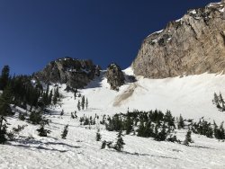
East Basin via Brown Duck
I'm leading a group of teenagers on a a 5 night backpacking trip from Hayden Pass trailhead
to West Fork Blacks Fork from July 15 to July 20.

While it looks like the snow is melting fast, I'm concerned about how much could still be there
in 18 days. I'll do a reconnaissance the weekend before to get a first hand look at Dead Horse Pass,
but I need to start considering a Plan B.

Any suggestions for a 35-55 mile backpacking that won't be hindered by snow the week of July 15?

Thanks
Grandaddy Basin for sure - although you might be postholing a little over Hades Pass and you would be stretching it to get your miles. East Basin via Moon Lake TH doing a loop through Squaw Basin, Kidney and Brown Duck Lakes would fill the miles and should miss most snow, plus provide some excellent fishing for those pesky teenagers.
 
Are you still going to do recon on the Hayden Lake TH etc.? We are looking at August 1 - 8, starting at Chepeta and ending at Hayden. Would love to hear about what you see.
 
So for anyone interested I spoke to the ranger in Stanley Idaho today and the route I planned there
is a no go. The pass just south of the Cramer lakes had waist deep snow on Monday (7/8). He strongly
encouraged me NOT to go that way.

I think I'm on plan F now.
 
So for anyone interested I spoke to the ranger in Stanley Idaho today and the route I planned there
is a no go. The pass just south of the Cramer lakes had waist deep snow on Monday (7/8). He strongly
encouraged me NOT to go that way.

I think I'm on plan F now.

Man! This year is being incredibly difficult!
 
Back
Top