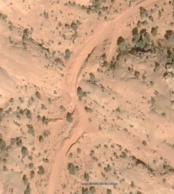
Old Mining Road along Dirty Devil

futurafree

Member
Joined
Apr 1, 2021
Messages
151
This past week I was supposed to do a nice loop from Burr Point: down to and across the river, take the old mining road above the Dirty Devil to Happy Canyon, then up Happy to the exit and over the Navajo sandstone domes to come back down via Sam's Mesa Canyon. I had drawn lines on the map for several potential spots where I could get down from the mining road to the river before Happy, but after the first two weaknesses/drainages didn't "go" I realized I didn't have enough water to stay up high in case the next two options also didn't work. So I played it safe and spent a 12+ mile day to end up at the starting point. I wasn't in the mood to thrash along the river for 10+ miles from Sam's Mesa to get to Happy, so I called an audible to just go up Sam's Mesa and down Twin Corral, which was a spicy fun little adventure in its own right (I'd remembered an old contentious thread on here and yeah, it had a couple interesting spots for this non-climber).
Anyway, has anyone found good spots to drop down from the mining road to the river between Sam's Mesa and Happy, preferably 0-2 miles upstream from Happy? The very last drainage the road crosses before Happy looked good, but the mouth of the drainage seems to end in a fall at the river.
 
coincidentally I was just looking at this exact issue and I would give very high odds that it's reasonable to work down to the DD from 38.153, -110.40. I didn't see anywhere closer to Happy C that looked likely.
 
Thanks, that one looks at least as good as the others I'd jotted down. The last 2 of the 4 lines I'd drawn were the last two major drainages that the road heads/crosses before Happy. Even though I know the last drainage ends in a fall at the mouth, I had seen a random Caltopo someone made that went down it and then up and over a minor ridge into Happy near its mouth. But I wasn't sure if that Caltopo route was a "recording" or a "proposed route". Looked like the last drop into Happy might not work on Google Earth.
Definitely keep me posted if you try this. I know the "Miner's Rappel" would be an easy entrance and then you could do the loop up Happy, down Sam's or Twin Corral, skip the mining road, and exit the conventional route up to Burr Point from near Twin Corral/Sam's, but I've never done a proper rappel alone and was just curious to try this specific loop. This loop could also be started from the Hans Flat Ranger Station road.
 
the route that I was hoping to do this spring (but it looks like I'm running out of time before it gets warm) is to drive out to Sam's Mesa up until the big washout, then walk to the tiny canyon that cuts into this Mesa between Happy and the one I linked above, which (I have heard but not verified) has a route from mesa level down to the mining road. then from there, visit the Happy narrows.

one of my quests is to visit the Happy narrow from as many ways as possible. so far I've not managed to walk Happy from top to bottom, that's also on my list. the Miner's rappel is NOT on my list.
 
the route that I was hoping to do this spring (but it looks like I'm running out of time before it gets warm) is to drive out to Sam's Mesa up until the big washout
If you look at the historical imagery in Google Earth, there is actually some newer imagery (maybe even from this year) than the default imagery that is rather poor quality, but it appears the washout has been repaired recently (if we're talking about the same washout).

1713300316032.png
 
If you look at the historical imagery in Google Earth, there is actually some newer imagery (maybe even from this year) than the default imagery that is rather poor quality, but it appears the washout has been repaired recently (if we're talking about the same washout).
thanks!! I've been avoiding that crappy new imagery, they have it in the Swell too, just ugly stuff
 
Back
Top