fossana
Member
- Joined
- Jan 11, 2018
- Messages
- 913

Background
Armed with a new hip and 2 months of obsessive training, I planned to test out my hip on one of my favorite big Sierra hikes, a loop through Evolution Basin and Darwin Canyon starting at Sabrina Lake and ending at North Lake. The route passes through some of the most prized terrain for Sierra hikers and climbers. My long-time Bishop friends and all-around overachieving couple, local volunteers and astrophysicists Stephen and Erik, agreed to join.
If all went well, I was planning to do a short, but rugged mostly off-trail backpacking loop in the Palisades one week later. Perhaps not the wisest move, I also did a 12 mile hike up Piute Pass the day prior to our hike with my SoCal friend, Joan, and fur niece, Pika.
Our Route
Start: Sabrina Lake/Basin trailhead
End: Sabrina Basin hiker overflow (painless bike shuttle option from N Lake trailhead)
Mileage: ~25 miles via GPS track
Elevation gain: ~7600 feet
Passes: Lamarck Col (~12,960'), Haeckel Col (~12,680')
Difficulty: class 3
View on Caltopo


Trip Report
I stayed up at elevation, and met Erik and Stephen in the morning. We set up a brief shuttle to the Sabrina Lake trailhead. Erik is a long-time Inyo SAR volunteer, and Stephen and I are used to playing catch-up; however, for the past few years Stephen has been ultrarunning in the alpine zone. Today, I knew I would be the extra slow one. The wildflowers and mosquitos were out as we crossed through Sabrina Basin (incentive to keep moving). Of note was also how unusually warm it was at altitude, another worrying sign of climate change and the likely smoke and fires that would follow later in the year.
")


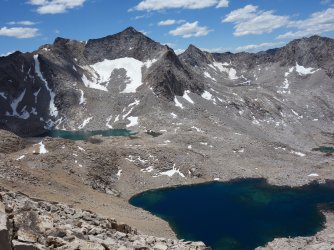
We made our way to Picture Peak (what Sierra bible author, RJ Secor, calls one of the most beautiful peaks in the Sierra) and Hungry Packer Lake. To avoid the long talus slog, we left the official trail and took the ridge to the right, bypassing the most striking view of the peak from the NE shore of the lake.
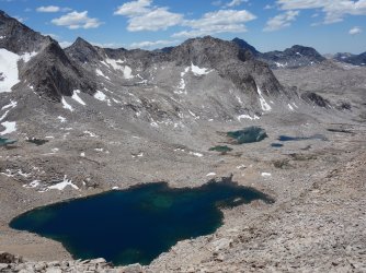
We stopped at the unnamed tarn below Haeckel to filter water, the most accessible water source on Evolution Traverse in low snow years. The climb to Haeckel Col was relatively painless, minor scree and talus to ramps. At the top of the ridge, the traditional route up Mt Haeckel (the broad chute) came into view.


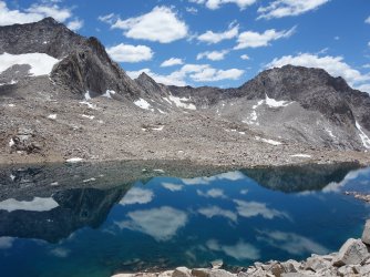
What I hadn't remembered was the long talus descent into the Spencer/Huxley Cirque. After what seemed like forever, we stepped onto the unusually dry meadows of Evolution Basin. My hip, however, was holding up well and it was nice to have my balance back. Stephen immediately jumped in the lake, while Erik and I opted for deep wading.


We contoured across the slabs and eventually made our way onto the JMT/PCT proper. It was remarkably quiet on one of the most coveted sections of the JMT, Evolution Basin, but that wouldn't last. As we approached Evolution Lake, there was a giant party of noisy backpackers and another group playing music on speakers. It might as well have been a SoCal beach.


We stopped briefly on the far shore of the lake for a snack before the last big climb up to Lamarck Col. We opted for the trail to Darwin Canyon instead of contouring up the ramps. The trail to Darwin Canyon has been rerouted to reduce impact, and the start was further down the JMT than we expected. On the upside, it now had wider, gentler switchbacks. My legs were starting to feel extra tired.


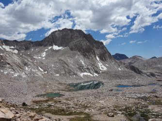
At the foot of Darwin Canyon and the start of Evolution Traverse, we ran into my Bishop friends, Emma and Matt. ~10 years ago, out of a blue I had run into Emma on Mt Haeckel at a low point in my attempt at the traverse. The apple she gave me kept me from bonking, and allowed me to finish off the route. I knew Emma and Matt were doing the North Lake/South Lake loop out of Lamarck Col, but I was surprised to find them so easily. We chatted with them for a while before hitting the gentle trail up Darwin Canyon. I hadn't been very hungry the past few days, and I had way too much food still left in my pack (sadly, a common theme for me at high altitude).


The streams and lakes in Darwin Canyon were surprisingly full, considering how dry Evolution Basin was. We walked the undulating trail, skirting the many lakes until we reached the last major obstacle, the ~1400' climb up Lamark Col. The altitude, distance, and my lack of calories were taking their toll. I caught a parting shot of Mt. Darwin. Stephen and Erik kindly waited for me at the pass even though I had told them multiple times along the way that they should feel free to head back on their own. I had done this section several times solo in the past.


Erik had wanted to reach the well-maintained, Lamarck Lakes trail proper by the time full darkness hit, and we made it, barely. Stephen ran ahead, and Erik and I walked the few miles back to the trailhead, then ~2 easy miles down the North Lake road to my vehicle. It was dark enough to see the Milky Way. While I could have done this solo, I was grateful to have friends along and to run into others on route. I felt bad for being slow, but given my recovery timeline I'll count it as a win.
Attachments
Last edited:
")