Hi! I have a group of college students who have planned a 7 day backpacking trip along the Escalate River. Starting at Harris Wash and coming out at Coyote Gulch. We are watching the river levels, but are starting to make a backup plan. Any advice on the likely hood of the water not being an issue mid May OR advice on other trips of similar length that we should check out. Thanks!
Navigation
Install the app
How to install the app on iOS
Follow along with the video below to see how to install our site as a web app on your home screen.
Note: This feature may not be available in some browsers.
More options
You are using an out of date browser. It may not display this or other websites correctly.
You should upgrade or use an alternative browser.
You should upgrade or use an alternative browser.
Escalante River Backpacking
- Thread starter Wandermom
- Start date
fossana
Member
- Joined
- Jan 11, 2018
- Messages
- 913
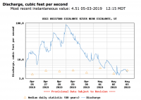
I've been watching the Escalante flow rate, and it's back down to normal for the moment with the cooler temps, granted this is measured near town. For reference 50 cfs is the min discharge rate recommendation for packrafting. As others have said keep an eye on it and call the ranger station before you go.


- Joined
- Aug 9, 2007
- Messages
- 12,951
As fossana suggested, that gauge is a horrible representation of what to expect between Harris and Coyote. Death Hollow, Calf Creek, Boulder Creek, Deer Creek, etc. all come in upstream and will be adding a lot of flow. Good advice to call the visitor center in Escalante, but your chances are still crap for mid-May this year. Even in drier times, that section can have enough water to make travel quite challenging, especially downstream from Ringtail where social trails are fewer and harder to find. Just fighting your way in and out of the river through the willows can take it out of you fast. That section is much better done in a packraft, or at least not in the spring of a record-setting water year. Also, the section from Harris/Fence down is frequently packrafted at much lower than 5cfs on the town gauge.
fossana
Member
- Joined
- Jan 11, 2018
- Messages
- 913
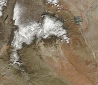
Looking like potential for more snow in the Escalante Range next week.
Duffbuddha
New Member
- Joined
- May 3, 2019
- Messages
- 3
That would keep the bug count down. I hear the no see ums and mosquitoes have been out of late.
Last edited:
- Joined
- Jan 4, 2015
- Messages
- 2,836
To be blunt, that trip sounds somewhere between a sufferfest and dangerous, given both the river level and the horrendous bushwhacking through there. If you're looking for something of similar length (and given that you're clearly already planning some sort of shuttle or self-shuttle), I'd switch gears and do, say, Grand Gulch from Kane Gulch to Collins Spring or something. Still a challenging trip with off-trail and some schwacking, but less flat-out awful than the Escalante would be.
Or head south and do something in the GC, say down Grandview and up Hermit or Spith Bass.
Or head south and do something in the GC, say down Grandview and up Hermit or Spith Bass.
Duffbuddha
New Member
- Joined
- May 3, 2019
- Messages
- 3
You guys seem keen to current conditions. Next weekend I am planning to access the Escalante via Ladder Canyon. And base camp a few bends down the river. I know the river levels can drastically fluctuate day to day. Anyone know if the river is higher than the normal bank channel? There is a crack spring that I am hoping to draw from that is about 5 feet higher than normal river levels. Thanks in advance.


