Camping In Yellowstone Basin

DrNed

The mountains are calling and I must go
Joined
Mar 31, 2013
Messages
1,026
I'm looking to next year's big trip and have decided to make a run at
King's Peak again.

<iframe width="100%" height="500px" src=" Click here to view on CalTopo"></iframe>

My plan is after summiting Kings to follow the Highline down into the
what I think is the Yellowstone Basin, eventually go over Smith's Fork
pass go into Red Castle.

What I'd like to do is camp somewhere along the Smith's Fork Pass
trail.

It appears to be all above the tree line. I'm wondering if there are camp
sites along the trail and how accessible is water?

Thanks.
 
Last edited:
When are you planning on being up there? My brother and I will be doing Kings on the 28th if all goes according to plans.


Sent from my iPhone using Tapatalk
 
for some reason @Cuberant link didnt work, so perhaps this one will, if you did not find it already...

https://backcountrypost.com/threads/uht-yellowstone-river-drainage-campsite.7025/#post-84163

It is true that the head of the Yellowstone is up above the treeline and I thought it was a great place to camp, or you can keep going and camp along a couple of the tarns that are there before Smith's Fork pass. On that same thread are also some great places down in the trees in the drainage. Just depends on what you want and the weather.

Sorry, some other additional thoughts.
I remember now you had asked about the offtrail cutting back from the trail above Lower Red Castle a while back?
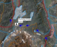
If you stay farther south than you have on the map with the blue arrows and keep at a line high enough above the marshy south end of the lake there is just a bit of talus and a little bit of marsh to route find around and you can camp on the other side of the lake and closer to Red Castle lake- that is where more people are... The fishing at Red Castle is infinitely better than Lower (meaning my buddies, not me actually caught fish both trips there). So we wanted to stay closer to Red Castle and not have to slog up past Lower to go fish.

My final note is change your Caltopo Base Layer from the Mapbuilder topo layer to the FSTopo 2016. The main/signed trail immediately from the footbridge by the outlet of Lower Red Castle up towards Smiths Fork Pass lake does not drop down into that marshy area east of Red Castle, it stays higher and passes closer to the "blue arrows" you have on the map. It just jumped out at me, because that area is a bit more confusing than it looks to route find offtrail.

I didn't mean to make that so long of a reply. There's a lot more to that area than just the camping by lower Red Castle that most people do...

Does this look right?
<iframe width="100%" height="500px" src=" Click here to view on CalTopo"></iframe>
 
If you stay farther south than you have on the map with the blue arrows and keep at a line high enough above the marshy south end of the lake there is just a bit of talus and a little bit of marsh to route find around and you can camp on the other side of the lake and closer to Red Castle
Red Castle Camp.jpg
More like this?
 
There is a trail in that general direction, but I cannot remember if we left it because we lost it, or if it was because of hopping over deadfall, or wanting to get above the trees, but I know that some of the horsepackers go that way and there is some form of a trail approx where you had routed your blue arrows.

When I went we were going uphill from Red Castle and just looked for what seemed easiest and so I went up above the trees.
I have been on the actual maintained trail a couple of times. The trail that goes from below Red Castle and seems to take the long way. Honestly, the time was not much different because the trail was easy to cruise along, just the route finding was more fun.

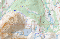
You might be amiss if you do not take a look at East Red Castle, and besides that, once you are there you can see downhill to more easily routefind and avoid the deadfall and marshy spots. So for what its worth, this is an estimated line I took, def. Not a gps track.
Near Red Castle there are some steeper areas but there are various ways down.

upload_2017-8-16_16-6-12.png
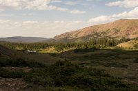
No pictures from the route, but this one is looking back down from East Red Castle. I stayed left of the small pond in the distance.
DSC_1799 down the drainage.jpg
 
View attachment 57146
No pictures from the route, but this one is looking back down from East Red Castle. I stayed left of the small pond in the distance.
View attachment 57147
Thanks for pointing out a better line of travel and
the image gives it some real context.

Do you know if East Red Castle can be seen from the Smith Fork Pass
trail?
 
Thanks for pointing out a better line of travel and
the image gives it some real context.

Do you know if East Red Castle can be seen from the Smith Fork Pass
trail?

Not exactly. Its a little higher altitude and in a bowl.
Coming up from Red castle, it's hidden up to your right.
Going down trail you more easily see the ponds east, but even many of the social trails are indistinct.
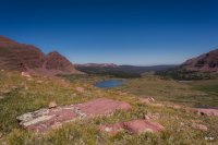
This is looking back partway up the pass. East Red Castle is tucked up under there in the bowl under the point of Red castles ridge, and tallus, and just left of the very visible Pass lake...just out of sight.
RC and Kings20150660 (1).jpg
 
Um, I had to be too dumb, but... where is this? I think I saw on one map Uintas... is it in Utah?

Pringles
 
Not exactly. Its a little higher altitude and in a bowl.
Coming up from Red castle, it's hidden up to your right.
Going down trail you more easily see the ponds east, but even many of the social trails are indistinct.
This is looking back partway up the pass. East Red Castle is tucked up under there in the bowl under the point of Red castles ridge, and tallus, and just left of the very visible Pass lake...just out of sight.
View attachment 61457
Very interesting!

I say that because assuming you're close to the trail
it might be better to actually leave the trail in this vicinity
because it looks like a clear line of travel to East Red Castle.

Having been there do you think?

Thanks for your photos! They really do add context that I
don't get in staring at the sat images.
 
Going north it's a bit more apparent where to leave the trail as there are some horsepack and fisher use trails.
There is a little fold you go up toward the lake that is easiest.
Where the ponds are on the map between the trail and the little cliff band it's normal Uintas marshy. The fold avoids most of that.
 
Back
Top