Red Rock Rangers
hiker-trash extraordinaire!
- Joined
- Sep 6, 2015
- Messages
- 23
Summer is here! St. George has officially entered the brutal 3-month stretch of 100°F+ degree weather. In some ways, desert summers are the evil twin of winters everywhere else -- you stay inside as much as possible, darting from one climate-controlled place to another, shouting expletives as you hop into the car. Ball caps instead of beanies. Smoothies instead of hot tea. Sunburn instead of frostbite. You get the idea.
Still, there are dozens of mountain ranges nearby. The Pine Valley Mountains, Cedar Mountain, Mt. Charleston, and Great Basin National Park all hover like lush beacons, promising green trees and bearable temperatures. We hunker down by the AC during the week, then flee to the high places on the weekend. Summer time = mountain time.
Whipple Valley
There's nothing better than looking back over a mountain ridge and knowing you've hiked across that monster.
manzanita + deer tracks (+ snow!)
To get to the trailhead, drive north from St. George along Highway 18 towards the town of Central. When you reach Central, you'll see a sign pointing towards Pine Valley. Turn right (east) along this road and follow it for 7.5 miles until you reach the town of Pine Valley. When you get to town, turn left on Main Street and follow the signs to the Pine Valley Recreation Area. Pay a small fee at the entrance station, then continue down the road. 1.3 miles past the entrance station, you'll see a paved road on the right that leads to the Pines Campground. Browns Point Trailhead is at the end of this road, which is where you'll end your hike -- stash your car here. The start of the hike is at the Whipple Trailhead, 1.5 miles down the road. Walk back to the main road, then continue right towards Blue Springs Campground. Whipple Trailhead is at the end of the road.
big views along the Whipple Trail
We started our hike at Whipple Trailhead, which immediately took us up, up, up into the mountains. We were surrounded by subalpine fir and Engelmann spruce, and got some great views of the town of Pine Valley below. After 4.6 miles of hiking and 2,400ft elevation gain, we reached the intersection of the Summit Trail and Whipple Valley. Whipple Valley is a gorgeous alpine meadow with a little creek running through it. It's a great spot, and our dog Frankie went absolutely buckwild with all the water, pinecones, snowy patches, and sticks. Seriously, the only thing she would have liked more was a pile of tennis balls! We turned right on the Summit Trail and hiked 0.7 mile until we reached South Valley, where we set up camp and called it a night.
home away from home
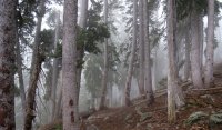
The next morning, we continued southwest along the Summit Trail. The trail was like a rollercoaster -- up, down, up, down. The hiking was tough, but the scenery was great. Some spots were socked in deep, dark forests with tons of deadfall, but then the trees would open up into lush meadows surrounded by rock outcroppings. Around midday, a foggy storm rolled across the Pines. The trail never went above treeline, so we weren't too worried about lightening. Instead, we wandered through a spooky mountain mist, soothing our desiccated desert brains.
6.6 miles past South Valley (7.3 miles after Whipple Valley) , we hit the intersection with Browns Point Trail, where we turned right (north) and hiked 3.8 miles back to our car. The 3,120ft elevation drop was steeeeeeep! Seriously, this sucker is a knee-buster, so bring trekking poles!
spooky mist rolling in
camouflaged husband

