kwc
Member
- Joined
- Mar 31, 2016
- Messages
- 938
The weather forecast looked and my wife was more than encouraging (is that a red flag?), and I really needed to get out onto the trails to see how much work I need to do on myself before hitting the trails with some unnamed BCP scallywags later on this year. It would also be a test of my new REI Flash 55 backpack. The original plan was 4 days, 3 nights, on a roughly 40 miles southern section of the trail. Ended up doing it in 3 days, 2 nights, simply because I pushed myself to go longer the first two days. So I am bit sore today and I need to do some more extended trips over the next couple of months.
After the first couple of miles you drop down to this view of Mud Pond, a shallow beaver pond

Another view of the pond

one of the many rocky water crossings that I encountered along the way

cool fungi
Stoney Creek that you have to wade across, ankle deep


one of many vlies that you encounter along the trail


Silver Lake

flowering tree along the way, found near a boggy area

The wood plank bridge through the bog

the area around that plank bridge


Another vlie

an Adirondack mud pit … figured this would be good practice for the scallywag adventure


Pink Lady Slipper

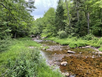
Suspension bridge over the West Branch of the Sacandaga River (we canoe this same river several miles to the west of here)

The river


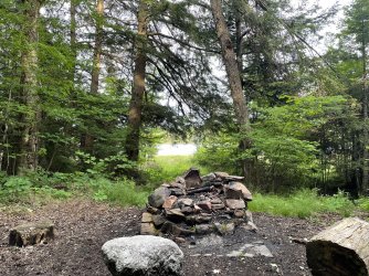
Old fireplace on the north side of the river after crossing the bridge … there used to be some sort of hotel or lodging here long ago

Another vlie

Some blowdown along the way. There was a considerable amount of blowdown in the one part of the trail on day two which slowed me down a bit

another suspension bridge, this one going over Hamilton Lake Stream. Very bouncy with some missing planks

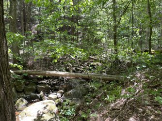
As you get closer to where I was ending my trek in Piseco, you come across this beauty of a water/beaver pond/swamp. Just before you cross on these logs you have to navigate over some slippery rocks, roots, and logs.

And after managing to stay upright for many miles I slipped on one of those logs before crossing and this was the result. It’s only a flesh wound.

Much of the trail has not had very much maintenance over the past few years. Some sections were very good, most were in dire need of some work. In true Adirondack fashion there are no switchbacks so the trail goes straight up or straight down which leads to excessive erosion from water running down the trail during heavy rain. And even though the air temperature was never more than 68 degrees, it was very humid/muggy in there and you are in the forest much of the time.
Night number one I tented in an off trail campsite that was on my Gaia map. Night number two was spent at the Mud Lake lean to (not to be confused with the Mud Pond that you encounter early on in day one) where I was serenaded by owls and the loons in the middle of the night.
I saw five people during my hike, 2 day trippers on day one and a group of three day trippers on my last day.
And then it started to rain when I was on y way home. Glad I was out of the woods then. Bugs were bad in some areas, not so bad in others. Mosquitoes most of the time with some deer flies appearing towards the end of my last day. Head net was used much of the time. And the backpack worked out fine.
After the first couple of miles you drop down to this view of Mud Pond, a shallow beaver pond
Another view of the pond
one of the many rocky water crossings that I encountered along the way
cool fungi
Stoney Creek that you have to wade across, ankle deep
one of many vlies that you encounter along the trail
Silver Lake
flowering tree along the way, found near a boggy area
The wood plank bridge through the bog
the area around that plank bridge
Another vlie
an Adirondack mud pit … figured this would be good practice for the scallywag adventure
Pink Lady Slipper
Suspension bridge over the West Branch of the Sacandaga River (we canoe this same river several miles to the west of here)
The river
Old fireplace on the north side of the river after crossing the bridge … there used to be some sort of hotel or lodging here long ago
Another vlie
Some blowdown along the way. There was a considerable amount of blowdown in the one part of the trail on day two which slowed me down a bit
another suspension bridge, this one going over Hamilton Lake Stream. Very bouncy with some missing planks
As you get closer to where I was ending my trek in Piseco, you come across this beauty of a water/beaver pond/swamp. Just before you cross on these logs you have to navigate over some slippery rocks, roots, and logs.
And after managing to stay upright for many miles I slipped on one of those logs before crossing and this was the result. It’s only a flesh wound.
Much of the trail has not had very much maintenance over the past few years. Some sections were very good, most were in dire need of some work. In true Adirondack fashion there are no switchbacks so the trail goes straight up or straight down which leads to excessive erosion from water running down the trail during heavy rain. And even though the air temperature was never more than 68 degrees, it was very humid/muggy in there and you are in the forest much of the time.
Night number one I tented in an off trail campsite that was on my Gaia map. Night number two was spent at the Mud Lake lean to (not to be confused with the Mud Pond that you encounter early on in day one) where I was serenaded by owls and the loons in the middle of the night.
I saw five people during my hike, 2 day trippers on day one and a group of three day trippers on my last day.
And then it started to rain when I was on y way home. Glad I was out of the woods then. Bugs were bad in some areas, not so bad in others. Mosquitoes most of the time with some deer flies appearing towards the end of my last day. Head net was used much of the time. And the backpack worked out fine.