Magic_Hour
ryancaryphoto.com
- Joined
- Nov 27, 2012
- Messages
- 15
When the Rains Came... The North Rim of the Grand Canyon
Here is a link to the original post on my BLOG...
After my short overnighter to the South Rim of the Grand Canyon I decided that perhaps a trip to the North Rim was in order. I already had a trip planned to hike into the Weminuche Wilderness of Southern Colorado, but with the weather the way it had been and the fact that in looking closely at Google Earth while planning my trip I realized that the sun wasn't going to be right for the shot I really wanted, I decided to set that trip aside and instead I headed back to The Canyon.
I had read a lot about an area called Torroweap or Tuweap, it's a primitive recreation area within the boundary of Grand Canyon National Park, however getting there requires a long drive on dirt roads into a pretty remote area of the canyon rim. There are actually three different driving routes described on the park webpage to get to the Torroweap area and the route that I took was the "Sunshine Route," which leaves the highway 8 miles west of Fredonia and heads in a southerly direction for about sixty miles. Before heading out on the long road I stopped at the visitor center in Jacob Lake and talked with the gentleman there about road conditions given all the recent rain in the area. His first response to the question of how the road conditions are heading to Torroweap was, "Horrible, like normal." This didn't really give me a huge feeling of confidence since all day as I was driving across the desert I had been watching a very large black cloud over what looked like the entire Arizona Strip region. None the less, the weather seemed pretty clear now and in talking further with him he said that it had stormed pretty hard that morning but he really hadn't heard anything in particular about bad road conditions going to Torroweap. He said that the road in is actually pretty decent for about the first fifty miles and then it gradually gets worse, and turns into a pretty rocky drive once you get into the park.
With that nugget of knowledge in my pocket I decided to head toward the turnoff to County Road #109, the road south to Torroweap where I figured I would make my final decision, based on the weather, as to whether or not I would head out down that long road or turn around and find a spot to shoot sunset somewhere else. As I came to the turnoff the sky was clear above me with a large storm in the distance to the south and east. The wind seemed to be blowing to the east and at best guess my chances of getting stuck out at Torroweap due to muddy roads seemed questionable. I figured it was the first day of a four day trip so if worse came to worse and I was stuck at Torroweap for a few days waiting for the roads to dry up so be it. With that I headed south.
The gentleman at the Visitor Center was right, the first fifty miles of road was really good. It was really a graded gravel road with only a couple of dry wash crossings and dirt spots that I figured might present a problem if it stormed a lot.
Here is a shot of what most of the beginning of County Road #109 looks like...
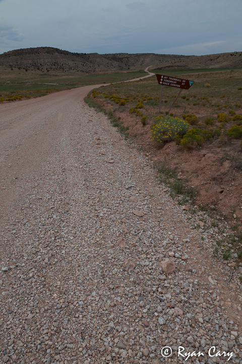
After a while of driving through the rolling high desert the road starts climbing through some small hills...
After probably the first fifty miles or so I crossed into the National Park and here the road got a little more rocky but still not bad at all in my opinion. There is a small ranger station a short ways into the park with an information board and a toilet. The board has information on it like reminding you to drive slow and mentioning that twenty-five percent of visitors to this area experience one or more flat tires. At this point I was still kind of confused because the road was really good so far. A few more miles down the road I passed a "High-Clearance Vehicle Required" sign so I figured I was about to see what all the fuss was about. So with all the build up I pressed on to find the road definitely get rocky, but still not all that bad in my opinion. Personally I would not drive a passenger car down it due to one rocky spot in particular on an uphill, but other than that I really didn't find much difficulty at all in driving it. Granted, I drove pretty slow to lessen the chances of popping a tire in such a remote location. I had made up my mind that since I only have one spare tire I would turn around immediately if I got a flat. Luckily I had no flat tires or other mishaps on the road.
My disclaimer in this is that I do drive a lot of easy to moderate four-wheel drive roads in my travels so I do have some sense of how to drive in these conditions. Personally I did not think the road was that bad but this is entirely subjective and I would take every precaution if planning a trip in to the Torroweap/Tuweap area, including extra food, clothing, repair items, spare tires, etc. The fact is, even though I didn't think the road was that bad, a mishap sixty miles from a paved road is still a big deal. The area is definitely remote. I was going to post a link to the National Park Service page about Torroweap, however the NPS seems to be shut down at the moment and their websites aren't working. None the less, once it comes back up and you are looking for information on the area make sure to read through the site carefully.
That being said, the road got rocky and there were a couple of spots that had some pretty jagged rocks sticking up, my Tacoma persevered through the worst of it and before I knew it I was at the small campground. At this point I was about an hour and a half from sunset so I knew that I didn't have a lot of time to waste. I turned into the campground not really knowing if there would be any spots available or not, the first three sites, being the most easily accessed were all taken. I headed down the short road through the campground and I'll say that I think the road in the campground was actually worse than the road coming in. None the less, I found a site and claimed it. A really nice feature of this remote site is that the campsites are free with a first-come first-served basis.
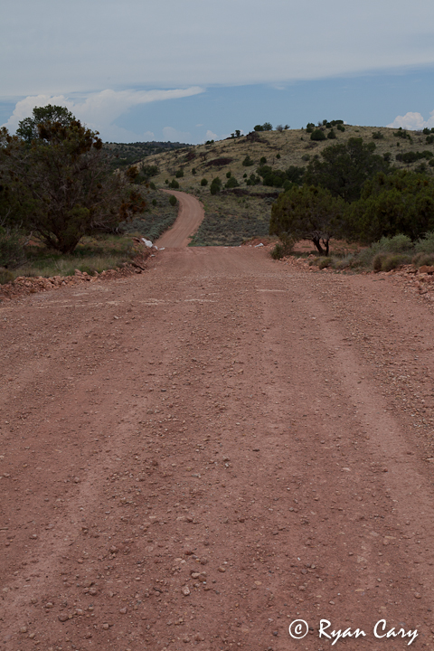
With my campsite claimed I headed out of the campground and turned toward the rim, I knew it was only a short ways to the rim from here but I figured with the light already good and the sun headed toward the horizon I would try to drive to the rim. For the most part the road between the campground and the rim looks a lot like this...
It wasn't long before I came to a large mud hole encompassing the entire width of the road.
I really wasn't sure what the bottom of the hole was like and I didn't have the time to try to figure out if I could drive through it without getting stuck in the mud or not so I parked at the Saddle Horse Canyon Loop Trailhead and walked briskly to the rim.
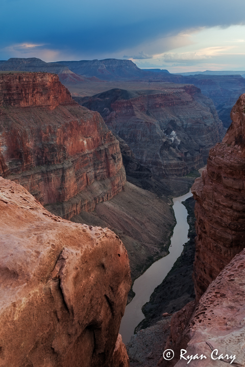
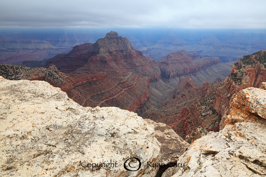
I quickly found the rim of the canyon (pretty hard to miss), and it was one of the most impressive views of the Grand Canyon that I have ever seen. The canyon here is at one of it's narrowest points and the walls of the canyon drop off dramatically three-thousand feet straight down. The rim here is lined with sandstone making for a variety of compositions and shots possible. Since I was pushing it for time I scurried along the rim trying to put together a good composition as the sun was already setting in front me. I found an interesting piece of sandstone and planted my tripod, shooting the grand display in front of me while listening to the song of the canyon winds whistling below me. It was a fantastic evening.
I walked back to my truck in the dark, really in the dark, since my headlamp must of somehow turned on in my pack and was currently dead (note to self, always have extra batteries on hand). Luckily I didn't run into any rattlesnakes on the road back to my truck and it was a relatively short and easy drive back to camp. After a quick dinner I relaxed by the campfire for a short while before heading to bed, hoping that no storms would roll in during the night.
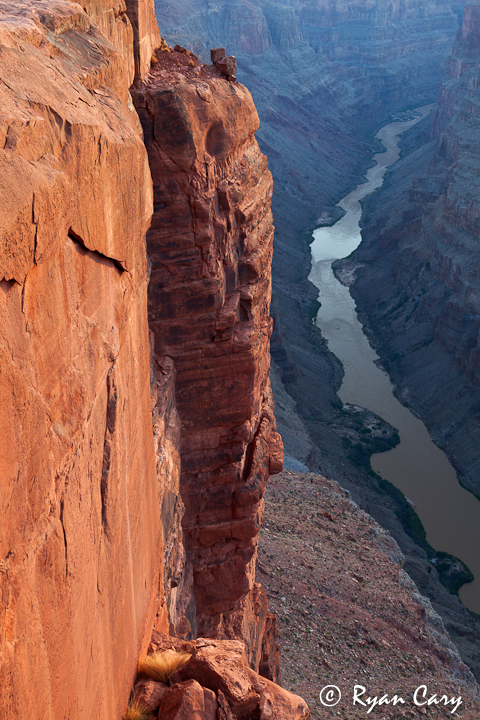
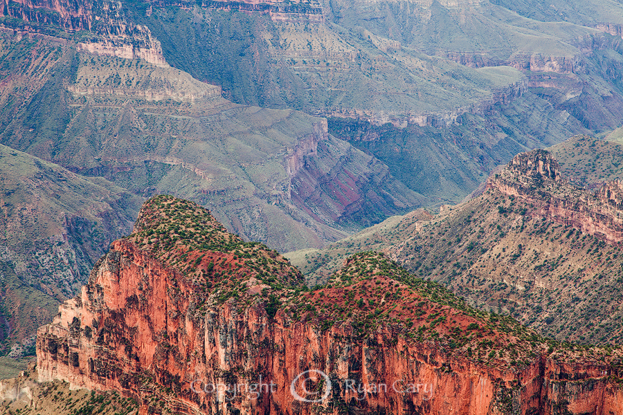
The next morning I rolled out of bed (actually the back of truck) and was hiking down the road toward the rim before I knew it. There is a classic shot from the Torroweap Overlook that I wanted to try and capture so I set up my tripod and camera looking to the east and I waited. The sunrise dawned with a few clouds overhead. There was just enough cloud cover to make the canyon walls glow from the soft light of morning, making for another memorable and beautiful sunrise shoot.
To the south, across the canyon, there was another large storm looming. It didn't seem to be moving very fast but I knew that if it caught me out here I was probably going to be stuck for awhile. The road in wasn't as bad as I thought it was going to be but there were still a couple of spots among the long gravel road where it looked like it would become a mud pit in a heavy rain.
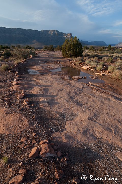
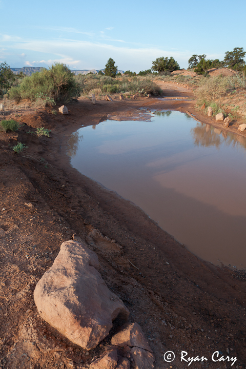
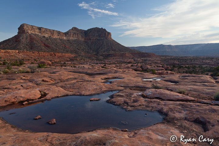
My plan for the morning was to try to make it to a rock art site just outside of the National Park Boundary in what is now Grand Canyon - Parashant National Monument. As I headed out down the rocky road leaving the Tuweap Area I noticed that the recent rains had filled a lot of the potholes on the sandstone in the area. The morning sun was still giving good light so I stopped and explored a little sandstone area just north of the Torroweap Campground with a nice view of Torroweap Point in the distance.
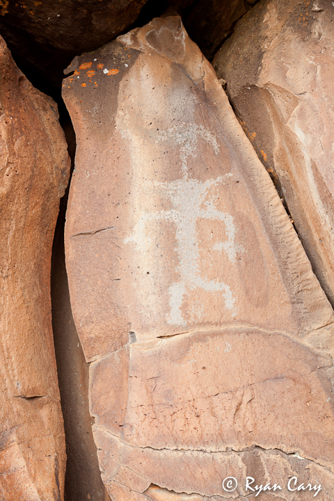
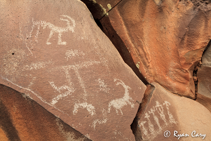
After that I made pretty good time getting to Nampaweap, the rock art site I was looking for. It's actually a site developed by the Park Service and BLM so there is a trail and interpretive signs at the parking area. An easy walk brought me to a small canyon, named Billy Goat Canyon, that at one time was presumably a main travel route for the ancient inhabitants of the area.
Among the lava rock boulders that line the walls of the canyon are hundreds of petroglyphs. The dark rock makes a nice backdrop for the ancient art work, adding to the variety of compositions that can be made while photographing. I was a bit distracted during this shoot due to the impending storm that seemed to be slowly heading my way, but none the less I still enjoyed shooting the rock art and doing a little exploring.
After about an hour of shooting I felt that I probably had pushed my luck as far as I should so I hightailed it back to my truck, packed up, and headed back toward the highway. I was happy with my decision when I saw the first rain drops hit my windshield just as I pulled onto the pavement of Highway 389. A sudden sense of relief came over me as I crested an overlook east of Fredonia and stopped for lunch, witnessing the storm that had been haunting me all morning boiling over the area that I had just left with lightning and sheets of rain driving down.
I figured I was pretty much in the clear since I was planning on heading to the National Park Area with plenty of paved roads. It rained for about an hour on my way to the park and then the skies cleared giving way to scattered clouds. I was hopeful for a good sunset but I still didn't know exactly where I wanted to shoot.
To make a long story short, once it started raining it never really stopped, this storm pretty much started the next two weeks of almost solid rain for the area. I ended up staying on the North Rim for another three days in hopes that there would be some opportune breaks in the weather to shoot some images however this time the rain definitely prevailed and left very little room for shooting. I did manage to get out a couple of times, including a hike along Cliff Springs Trail, which I highly recommend for a rainy day on the North Rim. The trail is pretty short and it leads to some pretty interesting pictographs. The best thing about it is that a lot of the trail is under some large overhangs in the cliff so even if it's raining you can still shoot some pictures if you want to, or just enjoy being outdoors and not getting soaked! I also did head out to some viewpoints and made a few images between downpours but for the most part it was way too foggy and cloudy to really provide good light for photography.
It was a great trip for exploring and seeing some things that I have always wanted to see and once again it has planted the seed for future trips to the North Rim.
Featured image for home page:

Here is a link to the original post on my BLOG...
After my short overnighter to the South Rim of the Grand Canyon I decided that perhaps a trip to the North Rim was in order. I already had a trip planned to hike into the Weminuche Wilderness of Southern Colorado, but with the weather the way it had been and the fact that in looking closely at Google Earth while planning my trip I realized that the sun wasn't going to be right for the shot I really wanted, I decided to set that trip aside and instead I headed back to The Canyon.
I had read a lot about an area called Torroweap or Tuweap, it's a primitive recreation area within the boundary of Grand Canyon National Park, however getting there requires a long drive on dirt roads into a pretty remote area of the canyon rim. There are actually three different driving routes described on the park webpage to get to the Torroweap area and the route that I took was the "Sunshine Route," which leaves the highway 8 miles west of Fredonia and heads in a southerly direction for about sixty miles. Before heading out on the long road I stopped at the visitor center in Jacob Lake and talked with the gentleman there about road conditions given all the recent rain in the area. His first response to the question of how the road conditions are heading to Torroweap was, "Horrible, like normal." This didn't really give me a huge feeling of confidence since all day as I was driving across the desert I had been watching a very large black cloud over what looked like the entire Arizona Strip region. None the less, the weather seemed pretty clear now and in talking further with him he said that it had stormed pretty hard that morning but he really hadn't heard anything in particular about bad road conditions going to Torroweap. He said that the road in is actually pretty decent for about the first fifty miles and then it gradually gets worse, and turns into a pretty rocky drive once you get into the park.
With that nugget of knowledge in my pocket I decided to head toward the turnoff to County Road #109, the road south to Torroweap where I figured I would make my final decision, based on the weather, as to whether or not I would head out down that long road or turn around and find a spot to shoot sunset somewhere else. As I came to the turnoff the sky was clear above me with a large storm in the distance to the south and east. The wind seemed to be blowing to the east and at best guess my chances of getting stuck out at Torroweap due to muddy roads seemed questionable. I figured it was the first day of a four day trip so if worse came to worse and I was stuck at Torroweap for a few days waiting for the roads to dry up so be it. With that I headed south.
The gentleman at the Visitor Center was right, the first fifty miles of road was really good. It was really a graded gravel road with only a couple of dry wash crossings and dirt spots that I figured might present a problem if it stormed a lot.
Here is a shot of what most of the beginning of County Road #109 looks like...
After a while of driving through the rolling high desert the road starts climbing through some small hills...
After probably the first fifty miles or so I crossed into the National Park and here the road got a little more rocky but still not bad at all in my opinion. There is a small ranger station a short ways into the park with an information board and a toilet. The board has information on it like reminding you to drive slow and mentioning that twenty-five percent of visitors to this area experience one or more flat tires. At this point I was still kind of confused because the road was really good so far. A few more miles down the road I passed a "High-Clearance Vehicle Required" sign so I figured I was about to see what all the fuss was about. So with all the build up I pressed on to find the road definitely get rocky, but still not all that bad in my opinion. Personally I would not drive a passenger car down it due to one rocky spot in particular on an uphill, but other than that I really didn't find much difficulty at all in driving it. Granted, I drove pretty slow to lessen the chances of popping a tire in such a remote location. I had made up my mind that since I only have one spare tire I would turn around immediately if I got a flat. Luckily I had no flat tires or other mishaps on the road.
My disclaimer in this is that I do drive a lot of easy to moderate four-wheel drive roads in my travels so I do have some sense of how to drive in these conditions. Personally I did not think the road was that bad but this is entirely subjective and I would take every precaution if planning a trip in to the Torroweap/Tuweap area, including extra food, clothing, repair items, spare tires, etc. The fact is, even though I didn't think the road was that bad, a mishap sixty miles from a paved road is still a big deal. The area is definitely remote. I was going to post a link to the National Park Service page about Torroweap, however the NPS seems to be shut down at the moment and their websites aren't working. None the less, once it comes back up and you are looking for information on the area make sure to read through the site carefully.
That being said, the road got rocky and there were a couple of spots that had some pretty jagged rocks sticking up, my Tacoma persevered through the worst of it and before I knew it I was at the small campground. At this point I was about an hour and a half from sunset so I knew that I didn't have a lot of time to waste. I turned into the campground not really knowing if there would be any spots available or not, the first three sites, being the most easily accessed were all taken. I headed down the short road through the campground and I'll say that I think the road in the campground was actually worse than the road coming in. None the less, I found a site and claimed it. A really nice feature of this remote site is that the campsites are free with a first-come first-served basis.
With my campsite claimed I headed out of the campground and turned toward the rim, I knew it was only a short ways to the rim from here but I figured with the light already good and the sun headed toward the horizon I would try to drive to the rim. For the most part the road between the campground and the rim looks a lot like this...
It wasn't long before I came to a large mud hole encompassing the entire width of the road.
I really wasn't sure what the bottom of the hole was like and I didn't have the time to try to figure out if I could drive through it without getting stuck in the mud or not so I parked at the Saddle Horse Canyon Loop Trailhead and walked briskly to the rim.
I quickly found the rim of the canyon (pretty hard to miss), and it was one of the most impressive views of the Grand Canyon that I have ever seen. The canyon here is at one of it's narrowest points and the walls of the canyon drop off dramatically three-thousand feet straight down. The rim here is lined with sandstone making for a variety of compositions and shots possible. Since I was pushing it for time I scurried along the rim trying to put together a good composition as the sun was already setting in front me. I found an interesting piece of sandstone and planted my tripod, shooting the grand display in front of me while listening to the song of the canyon winds whistling below me. It was a fantastic evening.
I walked back to my truck in the dark, really in the dark, since my headlamp must of somehow turned on in my pack and was currently dead (note to self, always have extra batteries on hand). Luckily I didn't run into any rattlesnakes on the road back to my truck and it was a relatively short and easy drive back to camp. After a quick dinner I relaxed by the campfire for a short while before heading to bed, hoping that no storms would roll in during the night.
The next morning I rolled out of bed (actually the back of truck) and was hiking down the road toward the rim before I knew it. There is a classic shot from the Torroweap Overlook that I wanted to try and capture so I set up my tripod and camera looking to the east and I waited. The sunrise dawned with a few clouds overhead. There was just enough cloud cover to make the canyon walls glow from the soft light of morning, making for another memorable and beautiful sunrise shoot.
To the south, across the canyon, there was another large storm looming. It didn't seem to be moving very fast but I knew that if it caught me out here I was probably going to be stuck for awhile. The road in wasn't as bad as I thought it was going to be but there were still a couple of spots among the long gravel road where it looked like it would become a mud pit in a heavy rain.
My plan for the morning was to try to make it to a rock art site just outside of the National Park Boundary in what is now Grand Canyon - Parashant National Monument. As I headed out down the rocky road leaving the Tuweap Area I noticed that the recent rains had filled a lot of the potholes on the sandstone in the area. The morning sun was still giving good light so I stopped and explored a little sandstone area just north of the Torroweap Campground with a nice view of Torroweap Point in the distance.
After that I made pretty good time getting to Nampaweap, the rock art site I was looking for. It's actually a site developed by the Park Service and BLM so there is a trail and interpretive signs at the parking area. An easy walk brought me to a small canyon, named Billy Goat Canyon, that at one time was presumably a main travel route for the ancient inhabitants of the area.
Among the lava rock boulders that line the walls of the canyon are hundreds of petroglyphs. The dark rock makes a nice backdrop for the ancient art work, adding to the variety of compositions that can be made while photographing. I was a bit distracted during this shoot due to the impending storm that seemed to be slowly heading my way, but none the less I still enjoyed shooting the rock art and doing a little exploring.
After about an hour of shooting I felt that I probably had pushed my luck as far as I should so I hightailed it back to my truck, packed up, and headed back toward the highway. I was happy with my decision when I saw the first rain drops hit my windshield just as I pulled onto the pavement of Highway 389. A sudden sense of relief came over me as I crested an overlook east of Fredonia and stopped for lunch, witnessing the storm that had been haunting me all morning boiling over the area that I had just left with lightning and sheets of rain driving down.
I figured I was pretty much in the clear since I was planning on heading to the National Park Area with plenty of paved roads. It rained for about an hour on my way to the park and then the skies cleared giving way to scattered clouds. I was hopeful for a good sunset but I still didn't know exactly where I wanted to shoot.
To make a long story short, once it started raining it never really stopped, this storm pretty much started the next two weeks of almost solid rain for the area. I ended up staying on the North Rim for another three days in hopes that there would be some opportune breaks in the weather to shoot some images however this time the rain definitely prevailed and left very little room for shooting. I did manage to get out a couple of times, including a hike along Cliff Springs Trail, which I highly recommend for a rainy day on the North Rim. The trail is pretty short and it leads to some pretty interesting pictographs. The best thing about it is that a lot of the trail is under some large overhangs in the cliff so even if it's raining you can still shoot some pictures if you want to, or just enjoy being outdoors and not getting soaked! I also did head out to some viewpoints and made a few images between downpours but for the most part it was way too foggy and cloudy to really provide good light for photography.
It was a great trip for exploring and seeing some things that I have always wanted to see and once again it has planted the seed for future trips to the North Rim.
Featured image for home page:
")