- Joined
- May 5, 2012
- Messages
- 1,725
I'm not superstitious, but Friday the 13th proved to be bad luck.
Since taking a new job a few months back, I've been looking forward to the first time off that would allow me a chance to take advantage of the favorable backpacking conditions in the Uintas this year.
That came in the form of a comp day on Friday, July 13. My brother and I set out for the north slope the evening prior, after I'd finished work for the day. We stayed at Uintalands, planning to awake early on Friday morning and drive along the North Slope Road to the West Fork Black's Fork drainage.
The drainage is a straight and narrow path leading along seemingly endless meadows into Dead Horse Lake. For many people the trail begins where the rocky, potholed road crosses the West Fork Black's Fork river. Being a low flow year, I was able to ford the river in my trusty 1994 Subaru Touring Wagon.
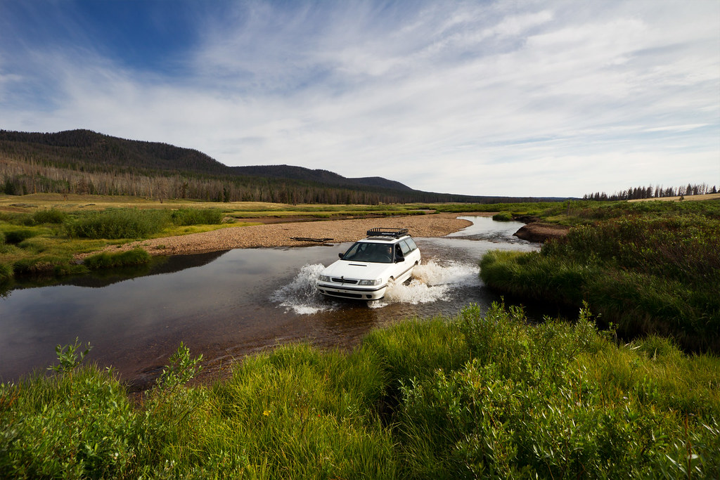
Crossing East Fork Black's Fork by ashergrey, on Flickr
The drainage is lightly used for camping and hiking, but heavily used by sheepherders. We encountered the herd spread across the hills immediately after crossing the river. It's not a small herd, either. We shot this video on the drive back out on Saturday (more on that bit later).
Once reaching the actual trailhead, you're confronted with a locked gate, a register and a trail marker. It's one of the less developed trailheads I've seen in the Uintas. There were no other cars there and only one other group signed in on the register. Perfect.

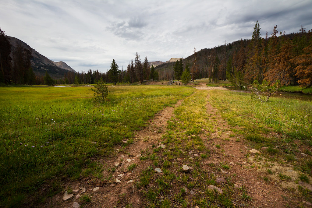
The first mile or so of the trail leads through pine forest, much of which is dead or dying. There is a ton of standing dead all through the drainage, especially on slopes between 9,000-10,000 feet. A wildfire would tear through West Fork if man or nature ever provided the spark. In a dry year such as this, many of the grasses were stunted and wildflowers were relatively scarce.
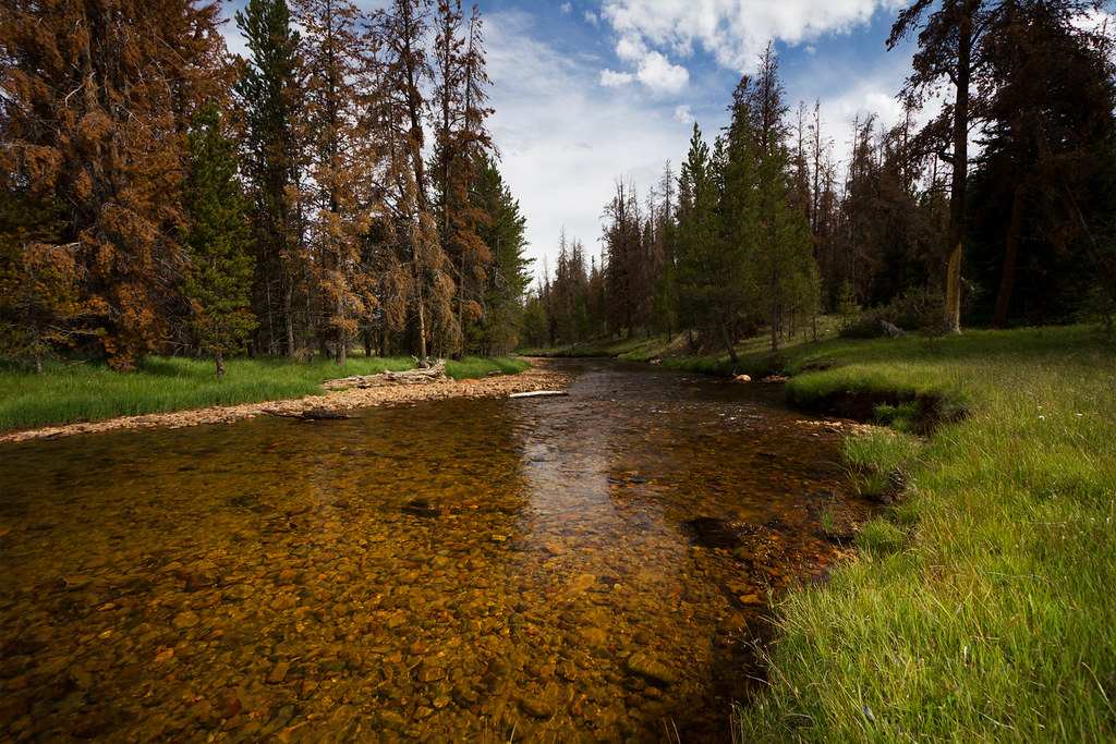
A wide double track, trail breaks out of the trees just before a river crossing.
First Crossing by ashergrey, on Flickr
On the other side, tucked in the forest on the west, is what appears to be a small weather station. I couldn't see that it was a NWS Snotel site, so I'm not sure its function. My brother and I missed it on the way up because, on the advice of internet posts, we skipped the crossing and veered east.
This meant forging our own path through Buck Pasture, a move that slowed our progress and exposed our boots to much marshy ground. The far wiser course is to follow the actual trail as it crosses the river and skirts the east side of the pasture.

West Fork Black's Fork River by ashergrey, on Flickr
Flat, lifeless gray clouds blotted out the sky for most of our walk along the seemingly infinite pasture. This frustrated the photographer in me. We kept our eyes peeled for wildlife across the swath of grass and brush but saw none. During the march we came across a line of posts running east to west through the pasture, each separated by about 150 yards. The wilderness boundary.

We rejoined the trail. The edges of the long pastures in West Fork Black's Fork are bordered by dilapidated sheep fences. These fences also cross the pastures laterally in a few spaces. A few crude sheepherder caches and campsites are scattered around as well, leaving one with the sense that much work needs to be done to make this drainage a true "wilderness".


After about eight miles the trail begins to ramp up in elevation, crossing the ever narrowing creek several times. Evidence of past glaciation becomes evident in the geology and geography. Deadfall from avalanche chutes are especially evident on the western slopes. The views of the surrounding peaks are great.
Less than a mile from the lake the trail intersects the Highline Trail, which comes in from the east over Red Knob Pass. A short climb from the signed intersection leads past Dead Horse Falls…
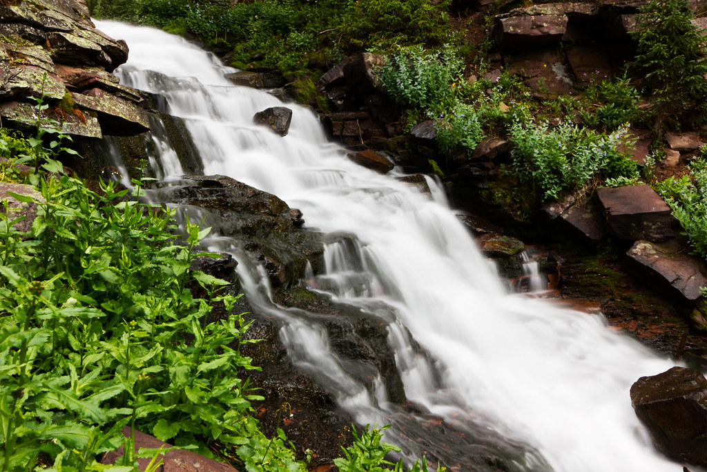
Dead Horse Falls by ashergrey, on Flickr
…and to Dead Horse Lake proper.
Dead Horse Lake by ashergrey, on Flickr
A good number of people were fishing the lake, well more than had signed in on the register. It's possible that they might have come in on the Highline Trail. We kept our distance.
Sore from the climb, we went about pitching camp before exploring the moraines and slopes above the treeline. Thick, ugly clouds were blowing over the ridge from the south but a particularly nasty surge actually came up the drainage from the opposite direction as we sat above Lake Ejod. This made for the best photo op of the trip, in the 45-second window after the rain. A stunning double rainbow straddled the lake as the squall climbed, hitting the contrary wind and shearing apart.
Rainbow over Ejod by ashergrey, on Flickr
My brother went to climb the pass separating the Dead Horse and Allsop cirques while I remained in the basin to shoot photos. I'd like to have gone with him, but I'd soaked my socks and boots by falling in the river at one point along the trail. I feared going up the pass sockless would leave me with some pretty good blisters for the hike out.
Ejod by ashergrey, on Flickr
Unfortunately, the sun disappeared behind the clouds and did not return for sunset. My brother and I reunited around twilight, headed back to camp and took care of dinner. The heavy cloud cover also robbed me of any chance to shoot star trails.
We both turned in, though I remained up reading Desert Solitaire awhile in the hopes the clouds would break. It was not to be.

The rain started about 45 minutes after I crawled into my bag. It pattered and splashed and pulsed on the wind. The surges came one after another, unceasing, all night long. All. Night. Long. Every time I managed to fade off to sleep, gusts hit the nylon parachute of my tent and startled me back to consciousness. Weary and frustrated, I started yelling at the weather round about 3 a.m.
It didn't get better. My hope had been that the storm would pass through the night and I'd be treated to some amazing light and clouds for sunrise photos. The weather cheated me out of this as well. When I woke around 6 a.m. the rain still pounded. An hour later I dressed and climbed out, intent to shoot something… anything… instead of remaining another instant in the muggy confines of the tent.
Between the Rain Showers by ashergrey, on Flickr
The cold wind and rain drove me back inside minutes later.
Discouraged, my brother and I broke camp in the rain, doing our best to work in the momentary lulls between waves of falling needles. He had only brought a 40-degree bag and was on the verge of cold throughout the night. Best I can guess the temperatures were in the mid to upper 30s.
Precipitation intensified as we hit the trail at about 9 a.m. We donned our ponchos and made as quick of progress as we could but the storms overtook us like crashing surf. By the time we reached Buck Pasture we were both soaked from rain, sweat and puddles. The wet marshes were now inundated bogs, choked with eight to ten inches of water. Our boots soaked through. Blister hotspots started on the balls of my feet, but both pairs of socks I'd brought were now drenched and neither of us wanted to stop in the rain long enough to deal with the problem. The walk felt more like swimming, or if not swimming at least like water-walking… the way old ladies do with little foam weights at the municipal pool.
Every time we looked back toward Dead Horse, the skies over the cirque appeared black and menacing. The sun would peer out every 15 minutes or so, pretending to be our friend. But really this was a ruse. His rays would heat us to the point of discomfort under our ponchos but the second we'd stop to drop packs and pull off a layer, the sun would again retreat behind his buttress of clouds and unleash a volley of stinging cold rain.
The slog felt like a death march at times. This time we stuck to the trail as it went east around most of Buck Pasture. My camera remained locked away under a rain-sleeved case the entire time. The rain finally eased to a scattered sprinkle when we were about two miles away from the trailhead. Already soaked and demoralized, we forded the river with our shoes on. This meant for the last two miles my leather boots squished with each step.
Round about this time we came across the only other people we saw on the trail the entire trip: Aldaron and his companion. They were heading up the trail. We exchanged hellos, not realizing we were fellow BCPosters.
Back at the car, we encountered one of the sheepherders. He was eager to talk to backcountry users about their opinions on grazing in the basin. We avoided a fight, basically saying we're happier with sheep than cows. He was very friendly, perhaps overly so.
The best part of the trip was taking off my soggy boots.
I could make a joke here about how bandwagon-jumpers who participate in these yuppie mud run events nowadays should try backpacking through a high-elevation rain storm before getting too smug and satisfied with themselves. But I'm way above that sort of thing. Waaaay above it. (See what I did there?)
I throughly enjoyed taking the beater wagon back across the West Fork Black's Fork river crossing, though this makes me wonder how long it will be before the Forest Service kills the crossing.
My brother shot a couple of timelapses from the trip using his GoPro. I'll add them here when he finishes putting them together.
The good news is this was my first outing with a new Big Agnes Grouse Mountain 15-degree mummy bag. It performed well. I was warm, on the verge of too warm most of the night. Initial impressions are that the bag's feature/gimmick involving a bottom sleeve for an inflatable sleeping pad works as advertised. I remained on the pad through the night, even as I tossed and turned. So there's some silver lining.
[PARSEHTML]<iframe src="http://www.mappingsupport.com/p/gmap4.php?q=http://dl.dropbox.com/u/3847512/GPS/Dead_Horse_Lake.kml&t=t4" frameborder="0" marginheight="0" scrolling="no" width="600" height="1200"></iframe><br><br>[/PARSEHTML]Featured image for home page:

Since taking a new job a few months back, I've been looking forward to the first time off that would allow me a chance to take advantage of the favorable backpacking conditions in the Uintas this year.
That came in the form of a comp day on Friday, July 13. My brother and I set out for the north slope the evening prior, after I'd finished work for the day. We stayed at Uintalands, planning to awake early on Friday morning and drive along the North Slope Road to the West Fork Black's Fork drainage.
The drainage is a straight and narrow path leading along seemingly endless meadows into Dead Horse Lake. For many people the trail begins where the rocky, potholed road crosses the West Fork Black's Fork river. Being a low flow year, I was able to ford the river in my trusty 1994 Subaru Touring Wagon.
Crossing East Fork Black's Fork by ashergrey, on Flickr
The drainage is lightly used for camping and hiking, but heavily used by sheepherders. We encountered the herd spread across the hills immediately after crossing the river. It's not a small herd, either. We shot this video on the drive back out on Saturday (more on that bit later).
Once reaching the actual trailhead, you're confronted with a locked gate, a register and a trail marker. It's one of the less developed trailheads I've seen in the Uintas. There were no other cars there and only one other group signed in on the register. Perfect.
The first mile or so of the trail leads through pine forest, much of which is dead or dying. There is a ton of standing dead all through the drainage, especially on slopes between 9,000-10,000 feet. A wildfire would tear through West Fork if man or nature ever provided the spark. In a dry year such as this, many of the grasses were stunted and wildflowers were relatively scarce.
A wide double track, trail breaks out of the trees just before a river crossing.
First Crossing by ashergrey, on Flickr
On the other side, tucked in the forest on the west, is what appears to be a small weather station. I couldn't see that it was a NWS Snotel site, so I'm not sure its function. My brother and I missed it on the way up because, on the advice of internet posts, we skipped the crossing and veered east.
This meant forging our own path through Buck Pasture, a move that slowed our progress and exposed our boots to much marshy ground. The far wiser course is to follow the actual trail as it crosses the river and skirts the east side of the pasture.
West Fork Black's Fork River by ashergrey, on Flickr
Flat, lifeless gray clouds blotted out the sky for most of our walk along the seemingly infinite pasture. This frustrated the photographer in me. We kept our eyes peeled for wildlife across the swath of grass and brush but saw none. During the march we came across a line of posts running east to west through the pasture, each separated by about 150 yards. The wilderness boundary.
We rejoined the trail. The edges of the long pastures in West Fork Black's Fork are bordered by dilapidated sheep fences. These fences also cross the pastures laterally in a few spaces. A few crude sheepherder caches and campsites are scattered around as well, leaving one with the sense that much work needs to be done to make this drainage a true "wilderness".
After about eight miles the trail begins to ramp up in elevation, crossing the ever narrowing creek several times. Evidence of past glaciation becomes evident in the geology and geography. Deadfall from avalanche chutes are especially evident on the western slopes. The views of the surrounding peaks are great.
Less than a mile from the lake the trail intersects the Highline Trail, which comes in from the east over Red Knob Pass. A short climb from the signed intersection leads past Dead Horse Falls…
Dead Horse Falls by ashergrey, on Flickr
…and to Dead Horse Lake proper.
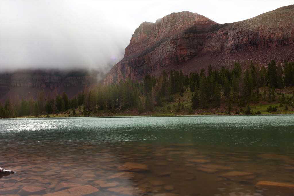
Dead Horse Lake by ashergrey, on Flickr
A good number of people were fishing the lake, well more than had signed in on the register. It's possible that they might have come in on the Highline Trail. We kept our distance.
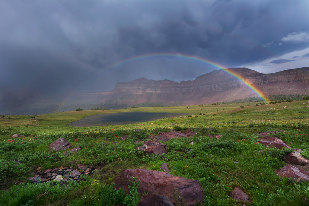
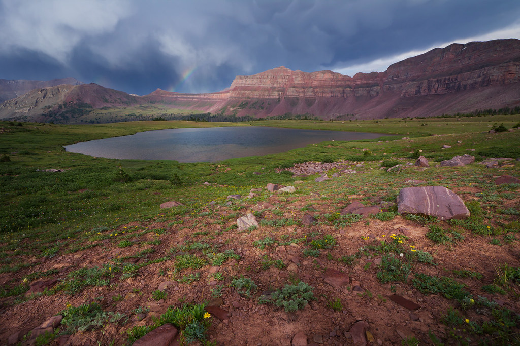
Sore from the climb, we went about pitching camp before exploring the moraines and slopes above the treeline. Thick, ugly clouds were blowing over the ridge from the south but a particularly nasty surge actually came up the drainage from the opposite direction as we sat above Lake Ejod. This made for the best photo op of the trip, in the 45-second window after the rain. A stunning double rainbow straddled the lake as the squall climbed, hitting the contrary wind and shearing apart.
Rainbow over Ejod by ashergrey, on Flickr
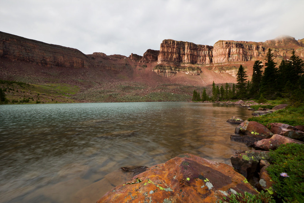
My brother went to climb the pass separating the Dead Horse and Allsop cirques while I remained in the basin to shoot photos. I'd like to have gone with him, but I'd soaked my socks and boots by falling in the river at one point along the trail. I feared going up the pass sockless would leave me with some pretty good blisters for the hike out.
Ejod by ashergrey, on Flickr
Unfortunately, the sun disappeared behind the clouds and did not return for sunset. My brother and I reunited around twilight, headed back to camp and took care of dinner. The heavy cloud cover also robbed me of any chance to shoot star trails.
We both turned in, though I remained up reading Desert Solitaire awhile in the hopes the clouds would break. It was not to be.
The rain started about 45 minutes after I crawled into my bag. It pattered and splashed and pulsed on the wind. The surges came one after another, unceasing, all night long. All. Night. Long. Every time I managed to fade off to sleep, gusts hit the nylon parachute of my tent and startled me back to consciousness. Weary and frustrated, I started yelling at the weather round about 3 a.m.
It didn't get better. My hope had been that the storm would pass through the night and I'd be treated to some amazing light and clouds for sunrise photos. The weather cheated me out of this as well. When I woke around 6 a.m. the rain still pounded. An hour later I dressed and climbed out, intent to shoot something… anything… instead of remaining another instant in the muggy confines of the tent.
Between the Rain Showers by ashergrey, on Flickr
The cold wind and rain drove me back inside minutes later.
Discouraged, my brother and I broke camp in the rain, doing our best to work in the momentary lulls between waves of falling needles. He had only brought a 40-degree bag and was on the verge of cold throughout the night. Best I can guess the temperatures were in the mid to upper 30s.
Precipitation intensified as we hit the trail at about 9 a.m. We donned our ponchos and made as quick of progress as we could but the storms overtook us like crashing surf. By the time we reached Buck Pasture we were both soaked from rain, sweat and puddles. The wet marshes were now inundated bogs, choked with eight to ten inches of water. Our boots soaked through. Blister hotspots started on the balls of my feet, but both pairs of socks I'd brought were now drenched and neither of us wanted to stop in the rain long enough to deal with the problem. The walk felt more like swimming, or if not swimming at least like water-walking… the way old ladies do with little foam weights at the municipal pool.
Every time we looked back toward Dead Horse, the skies over the cirque appeared black and menacing. The sun would peer out every 15 minutes or so, pretending to be our friend. But really this was a ruse. His rays would heat us to the point of discomfort under our ponchos but the second we'd stop to drop packs and pull off a layer, the sun would again retreat behind his buttress of clouds and unleash a volley of stinging cold rain.
The slog felt like a death march at times. This time we stuck to the trail as it went east around most of Buck Pasture. My camera remained locked away under a rain-sleeved case the entire time. The rain finally eased to a scattered sprinkle when we were about two miles away from the trailhead. Already soaked and demoralized, we forded the river with our shoes on. This meant for the last two miles my leather boots squished with each step.
Round about this time we came across the only other people we saw on the trail the entire trip: Aldaron and his companion. They were heading up the trail. We exchanged hellos, not realizing we were fellow BCPosters.
Back at the car, we encountered one of the sheepherders. He was eager to talk to backcountry users about their opinions on grazing in the basin. We avoided a fight, basically saying we're happier with sheep than cows. He was very friendly, perhaps overly so.
The best part of the trip was taking off my soggy boots.
I could make a joke here about how bandwagon-jumpers who participate in these yuppie mud run events nowadays should try backpacking through a high-elevation rain storm before getting too smug and satisfied with themselves. But I'm way above that sort of thing. Waaaay above it. (See what I did there?)
I throughly enjoyed taking the beater wagon back across the West Fork Black's Fork river crossing, though this makes me wonder how long it will be before the Forest Service kills the crossing.
My brother shot a couple of timelapses from the trip using his GoPro. I'll add them here when he finishes putting them together.
The good news is this was my first outing with a new Big Agnes Grouse Mountain 15-degree mummy bag. It performed well. I was warm, on the verge of too warm most of the night. Initial impressions are that the bag's feature/gimmick involving a bottom sleeve for an inflatable sleeping pad works as advertised. I remained on the pad through the night, even as I tossed and turned. So there's some silver lining.
[PARSEHTML]<iframe src="http://www.mappingsupport.com/p/gmap4.php?q=http://dl.dropbox.com/u/3847512/GPS/Dead_Horse_Lake.kml&t=t4" frameborder="0" marginheight="0" scrolling="no" width="600" height="1200"></iframe><br><br>[/PARSEHTML]Featured image for home page:

