Gretchen Millward
Member
- Joined
- Oct 6, 2021
- Messages
- 17
Hi folks, this trip is a return to Trachyte Creek, April 29 – May 2, 2022. (See also my prior trip report from October 2021.) It was my 49th canyon country adventure. I was joined by a long-standing hiking buddy who we’ll refer to as Richard Milhous Nixon.
Since the fall trip’s pre-dawn departure led to an extremely long, tiring Day 1, this time we left the afternoon of Day 0 (April 28) and stayed overnight at Recapture Lodge in Bluff, UT, which remains fantastic. They even held our late-night arrival despite my credit card being declined.
The photos are again black and white, though this time I used my “vintage” digital camera, an Olympus E-P3 from 2010. I figured that since my main workflow at present is posting online, and I don’t have time lately to develop and scan the film myself, I may as well re-try an all-digital workflow. It does have a black and white mode for the viewfinder, which was nice for composing. I processed them in Lightroom 5, circa 2014. It worked pretty well I think.

Mr. Nixon and myself at the trailhead.

Mr. Nixon crossing the uplands south of Trail Canyon.

Henry Mountains just before starting our descent into the Navajo Sandstone.
While this route was interesting and fun, and I’m glad we did it, it was by no means easier or faster than the Trail Canyon approach. I believe it took us over two hours and involved a lot of complex route-finding through and around small canyons.
We had lunch on a rock next to the creek, which was flowing vigorously.

A cottonwood tree near our lunch rock.

Mr. Nixon cooling his feet at lunch.
After lunch, we continued downstream. The destination was a sand bench shortly above the confluence with Woodruff Canyon.

The deep alcove where Trachyte Creek enters the Kayenta Formation.

Trachyte Creek entering the Wingate Sandstone.

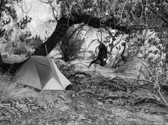
Our campsite.
After setting up camp, we had enough time for an afternoon hike into lower Woodruff to check it out. In particular, I wanted to verify the routes around the final fall: both Kelsey’s and the one suggested by a commenter here on my last report.

Seeps below our campsite. It turned out there is a sizeable spring just out of frame on the left of this photo, but we didn't notice it until the last evening!

Flower growing in the beach across from camp.

Trachyte Creek at the confluence with Woodruff.

Woodruff emerging from the Wingate Sandstone, one of the best confluences around. Here Woodruff was also flowing pretty well.

The famous chockstone and pool just above the confidence. It was definitely a swimming pool, not a wading pool.
After bypassing the chockstone (on river left), it wasn’t long before we had to wade. This was rough in bare feet, since we were obligated to cross a lot of cobbles and large gravel. I had correctly located Kelsey’s downclimb the previous fall, so we ascended to check things out. It was indeed not very hard, but I’m not sure I would have wanted to do it solo. Maybe Class 4 with enough exposure to be exciting.

Flower above the Kelsey downclimb.
We went upstream along the rim of the inner narrows to get a view and try to find the other route past the falls, and spotted a fixed rope on river left a short ways upstream. We decided to check it out.

Descending the Kelsey route.

Mr. Nixon approaching the fixed rope.
The water at the base of the climb was about hip deep. Neither of us would normally trust a fixed rope of unknown provenance, but in this case, if it broke, we would just get an unexpected bath, and getting out of the water without it looked to be quite a challenge. We ascended out of the pool, which led to a wide ledge that was an easy scramble to the top, though with a low duck-under of overhanging rock. From the top, we could see that it was an easy walk along the bench to the top of the blocking fall. This was way shorter than the Kelsey route, which requires ascending a few hundred feet to the top of the Wingate and back down again, and only modestly more difficult. We declared victory and turned around.

Mr. Nixon approaching camp after we re-gained Trachyte Creek.

Claret cup cactus blooming near the final fall in Woodruff.

Wind-carved small alcoves in the Wingate overlooking the fall.

Mr. Nixon heading up-canyon above the fall.

Flowers in Woodruff Canyon.

Flowers in Woodruff Canyon.

Water flowed continuously in lower Woodruff Canyon. Here, it flows over a ledge of the Kayenta Formation.
Lower Woodruff through the Kayenta and Wingate flows roughly parallel to Trachyte Creek. Near where our up-canyon travel changed from north-bound to east-bound, away from Trachyte and where the canyon enters the Navajo, the character of the canyon changes completely, entering a long region of open, meadowy forest.

Watercourse through the forest.
Finally the forest ended, the water disappeared, and we emerged into a more typical wide, dry Navajo wash. It wasn’t long before an intriguing-looking slot appeared on river right. Mr. Nixon wanted to explore it; I wanted lunch first. Being the former President of the United States of America (FPOTUS), Mr. Nixon’s opinion prevailed.

Mr. Nixon failing to ascend the minor fall that ends a short but spectacular section of walking narrows.
After Mr. Nixon flailed ridiculously for several minutes trying to ascend further, and my own considerably more dignified efforts were also unsuccessful, we returned to the main wash for lunch.

Our lunch spot at the mouth of the slot.
After lunch, we explored briefly upstream a bit more, then turned around.

The Henry Mountains from our turnaround point.

Poison ivy near the beginning of water in Woodruff Canyon.

Flowers in Woodruff Canyon.
After a while, we turned into a side canyon on river right that looked interesting. At the mouth, a daypack was hanging from a tree, and a few yards downstream was a pair of underwear in the wash. We put the underwear into the daypack. This will become important later.

The lower portion of the side canyon was a bit warm, before abruptly narrowing and turning left into a fault.

The non-technical portion of the side canyon ended with this fall.

Mr. Nixon proving that further travel up-canyon was impossible for us.

Tree stump just below the fall.
Suddenly we heard voices, and after a couple of minutes, young people in technical gear (I would guess age roughly 12 years old) began to emerge from the crack above the fall, apparently with considerable skill and care. They but spoke an unfamiliar language that superficially resembled English but was mostly words like “bet” and “sick” and “yeet”. After a brief and awkward but friendly attempt at communication, we returned down-canyon.

Sacred Datura growing in the sandy side canyon.

Woodruff’s stream flowing through the forest/meadow.
Soon we came to a side canyon on river left that, unlike the previous one, was wet and filled with the same forest as Woodruff itself.

Mr. Nixon exploring this third side canyon.

Apparently-ancient mud deposits under the blocking fall at the head of the side canyon.

Cottonwoods below the blocking fall.

We saw quite a few frogs along the stream in the Woodruff forest.

Navajo? cliffs in Woodruff Canyon.

Woodruff’s stream flowing through the Kayenta, below the forest.
When Woodruff turned from east to south, we decided to go up and over the pass into Trachyte Creek, rather than continue down Woodruff and swim again.

Claret cup cactus.

Small spring flowing into Trachyte Creek.
It was a long dayhike.

Our campsite above the confluence with Woodruff, prior to departure on our dayhike.

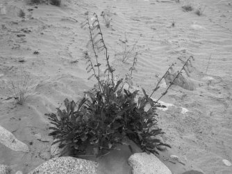
A plant growing on a beach in Trachyte somewhere downstream of camp.

Indian paintbrush petals on a beach.

More claret cup cactus.

Chinle Formation in lower Trachyte Creek.
The confluence with Swett is a wide, open area dominated by silt from Lake Powell.

A few hundred yards up Swett, the creek is guarded by a collection of hoodoos.

The famous Hoskinnini Monument in lower Swett Creek.
Mr. Nixon attempted to circumnavigate the Hoskinnini spire at its base and came close but failed. I hung out for a few minutes in the shade of a tree that until we arrived had held a small herd of cattle, which disappeared upstream. Every so often, we would come upon the herd again, but we were never able to pass around them before pushing them upstream. This will become important later.

A large rincon maybe a mile upstream from the Monument. Note the significant dip of the rocks away from Mount Holmes a couple of miles distant.

Chinle Formation boulder in Swett Creek.
As Swett approaches the Wingate, it begins to ascend rather steeply. We kept expecting to suddenly find the cows stuck, unable to proceed. But we didn’t. We stopped for lunch on a windy ledge at the very top of the Chinle.

Immediately upstream from lunch the canyon enters its Wingate narrows.
After lunch, we proceeded upstream to check out the narrows. However, there was ... a problem.

Damned cows.
The cattle had indeed found a spot where they could not proceed. It looked to be a small chockstone that would be easy for a person. Unfortunately, there was no room to go around, and neither of us was terribly jazzed to closely approach a group of pissed-off mama cows with calves. We tried yelling and throwing rocks from a few ledges but the cows were smart (dumb?) enough to conclude the rocks were less of a threat than us, and refused to go past. We gave up without seeing the narrows.

The rincon from upstream.

Wingate boulder in Swett Creek.

Lower Swett Creek.

Not far below camp, we took a detour up a ridiculous boulder heap of a side canyon in hopes of finding something cool. There was a cool-looking Wingate slot, but not for us.

While supper was cooking, we undertook some (temporary) improvements on the spring, which we’d finally located. We captured maybe a third of the flow, which was enough to fill a water bottle in a reasonable amount of time.

Trachyte Creek looking upstream from my fall campsite.

Cottonwood overlooking my fall campsite.
The hike out was short but per usual rather a slog over the cobbles of Trail Canyon. Mr. Nixon observed that next time we went to that campsite, he would prefer to enter via Woodruff. I’d agree.

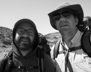
Mr. Nixon and myself “after” another successful hike.
That’s all folks! Thanks for your time reading, and I would be happy to answer any questions.
Since the fall trip’s pre-dawn departure led to an extremely long, tiring Day 1, this time we left the afternoon of Day 0 (April 28) and stayed overnight at Recapture Lodge in Bluff, UT, which remains fantastic. They even held our late-night arrival despite my credit card being declined.
The photos are again black and white, though this time I used my “vintage” digital camera, an Olympus E-P3 from 2010. I figured that since my main workflow at present is posting online, and I don’t have time lately to develop and scan the film myself, I may as well re-try an all-digital workflow. It does have a black and white mode for the viewfinder, which was nice for composing. I processed them in Lightroom 5, circa 2014. It worked pretty well I think.
Day 1
We were on-trail maybe 10am or so, starting from the Trail Canyon trailhead. We tried an entry route that I’ve been eyeing for some years, which is to travel overland to the bench between Trachyte Creek and Woodruff Canyon, then descend into Trachyte a short distance below its confluence with Trail Canyon.Mr. Nixon and myself at the trailhead.
Mr. Nixon crossing the uplands south of Trail Canyon.
Henry Mountains just before starting our descent into the Navajo Sandstone.
While this route was interesting and fun, and I’m glad we did it, it was by no means easier or faster than the Trail Canyon approach. I believe it took us over two hours and involved a lot of complex route-finding through and around small canyons.
We had lunch on a rock next to the creek, which was flowing vigorously.
A cottonwood tree near our lunch rock.
Mr. Nixon cooling his feet at lunch.
After lunch, we continued downstream. The destination was a sand bench shortly above the confluence with Woodruff Canyon.
The deep alcove where Trachyte Creek enters the Kayenta Formation.
Trachyte Creek entering the Wingate Sandstone.
Our campsite.
After setting up camp, we had enough time for an afternoon hike into lower Woodruff to check it out. In particular, I wanted to verify the routes around the final fall: both Kelsey’s and the one suggested by a commenter here on my last report.
Seeps below our campsite. It turned out there is a sizeable spring just out of frame on the left of this photo, but we didn't notice it until the last evening!
Flower growing in the beach across from camp.
Trachyte Creek at the confluence with Woodruff.
Woodruff emerging from the Wingate Sandstone, one of the best confluences around. Here Woodruff was also flowing pretty well.
The famous chockstone and pool just above the confidence. It was definitely a swimming pool, not a wading pool.
After bypassing the chockstone (on river left), it wasn’t long before we had to wade. This was rough in bare feet, since we were obligated to cross a lot of cobbles and large gravel. I had correctly located Kelsey’s downclimb the previous fall, so we ascended to check things out. It was indeed not very hard, but I’m not sure I would have wanted to do it solo. Maybe Class 4 with enough exposure to be exciting.
Flower above the Kelsey downclimb.
We went upstream along the rim of the inner narrows to get a view and try to find the other route past the falls, and spotted a fixed rope on river left a short ways upstream. We decided to check it out.
Descending the Kelsey route.
Mr. Nixon approaching the fixed rope.
The water at the base of the climb was about hip deep. Neither of us would normally trust a fixed rope of unknown provenance, but in this case, if it broke, we would just get an unexpected bath, and getting out of the water without it looked to be quite a challenge. We ascended out of the pool, which led to a wide ledge that was an easy scramble to the top, though with a low duck-under of overhanging rock. From the top, we could see that it was an easy walk along the bench to the top of the blocking fall. This was way shorter than the Kelsey route, which requires ascending a few hundred feet to the top of the Wingate and back down again, and only modestly more difficult. We declared victory and turned around.
Mr. Nixon approaching camp after we re-gained Trachyte Creek.
Day 2
The plan for the day was simply to ascend Woodruff Canyon as far as we could go and see what cool stuff there was.Claret cup cactus blooming near the final fall in Woodruff.
Wind-carved small alcoves in the Wingate overlooking the fall.
Mr. Nixon heading up-canyon above the fall.
Flowers in Woodruff Canyon.
Flowers in Woodruff Canyon.
Water flowed continuously in lower Woodruff Canyon. Here, it flows over a ledge of the Kayenta Formation.
Lower Woodruff through the Kayenta and Wingate flows roughly parallel to Trachyte Creek. Near where our up-canyon travel changed from north-bound to east-bound, away from Trachyte and where the canyon enters the Navajo, the character of the canyon changes completely, entering a long region of open, meadowy forest.
Watercourse through the forest.
Finally the forest ended, the water disappeared, and we emerged into a more typical wide, dry Navajo wash. It wasn’t long before an intriguing-looking slot appeared on river right. Mr. Nixon wanted to explore it; I wanted lunch first. Being the former President of the United States of America (FPOTUS), Mr. Nixon’s opinion prevailed.
Mr. Nixon failing to ascend the minor fall that ends a short but spectacular section of walking narrows.
After Mr. Nixon flailed ridiculously for several minutes trying to ascend further, and my own considerably more dignified efforts were also unsuccessful, we returned to the main wash for lunch.
Our lunch spot at the mouth of the slot.
After lunch, we explored briefly upstream a bit more, then turned around.
The Henry Mountains from our turnaround point.
Poison ivy near the beginning of water in Woodruff Canyon.
Flowers in Woodruff Canyon.
After a while, we turned into a side canyon on river right that looked interesting. At the mouth, a daypack was hanging from a tree, and a few yards downstream was a pair of underwear in the wash. We put the underwear into the daypack. This will become important later.
The lower portion of the side canyon was a bit warm, before abruptly narrowing and turning left into a fault.
The non-technical portion of the side canyon ended with this fall.
Mr. Nixon proving that further travel up-canyon was impossible for us.
Tree stump just below the fall.
Suddenly we heard voices, and after a couple of minutes, young people in technical gear (I would guess age roughly 12 years old) began to emerge from the crack above the fall, apparently with considerable skill and care. They but spoke an unfamiliar language that superficially resembled English but was mostly words like “bet” and “sick” and “yeet”. After a brief and awkward but friendly attempt at communication, we returned down-canyon.
Sacred Datura growing in the sandy side canyon.
Woodruff’s stream flowing through the forest/meadow.
Soon we came to a side canyon on river left that, unlike the previous one, was wet and filled with the same forest as Woodruff itself.
Mr. Nixon exploring this third side canyon.
Apparently-ancient mud deposits under the blocking fall at the head of the side canyon.
Cottonwoods below the blocking fall.
We saw quite a few frogs along the stream in the Woodruff forest.
Navajo? cliffs in Woodruff Canyon.
Woodruff’s stream flowing through the Kayenta, below the forest.
When Woodruff turned from east to south, we decided to go up and over the pass into Trachyte Creek, rather than continue down Woodruff and swim again.
Claret cup cactus.
Small spring flowing into Trachyte Creek.
It was a long dayhike.
Day 3
The planned destination today was to explore Swett Creek, hopefully including the narrows. This meant hiking down Trachyte for 1–2 hours to the confluence, then go up Swett.Our campsite above the confluence with Woodruff, prior to departure on our dayhike.
A plant growing on a beach in Trachyte somewhere downstream of camp.
Indian paintbrush petals on a beach.
More claret cup cactus.
Chinle Formation in lower Trachyte Creek.
The confluence with Swett is a wide, open area dominated by silt from Lake Powell.
A few hundred yards up Swett, the creek is guarded by a collection of hoodoos.
The famous Hoskinnini Monument in lower Swett Creek.
Mr. Nixon attempted to circumnavigate the Hoskinnini spire at its base and came close but failed. I hung out for a few minutes in the shade of a tree that until we arrived had held a small herd of cattle, which disappeared upstream. Every so often, we would come upon the herd again, but we were never able to pass around them before pushing them upstream. This will become important later.
A large rincon maybe a mile upstream from the Monument. Note the significant dip of the rocks away from Mount Holmes a couple of miles distant.
Chinle Formation boulder in Swett Creek.
As Swett approaches the Wingate, it begins to ascend rather steeply. We kept expecting to suddenly find the cows stuck, unable to proceed. But we didn’t. We stopped for lunch on a windy ledge at the very top of the Chinle.
Immediately upstream from lunch the canyon enters its Wingate narrows.
After lunch, we proceeded upstream to check out the narrows. However, there was ... a problem.
Damned cows.
The cattle had indeed found a spot where they could not proceed. It looked to be a small chockstone that would be easy for a person. Unfortunately, there was no room to go around, and neither of us was terribly jazzed to closely approach a group of pissed-off mama cows with calves. We tried yelling and throwing rocks from a few ledges but the cows were smart (dumb?) enough to conclude the rocks were less of a threat than us, and refused to go past. We gave up without seeing the narrows.
The rincon from upstream.
Wingate boulder in Swett Creek.
Lower Swett Creek.
Not far below camp, we took a detour up a ridiculous boulder heap of a side canyon in hopes of finding something cool. There was a cool-looking Wingate slot, but not for us.
While supper was cooking, we undertook some (temporary) improvements on the spring, which we’d finally located. We captured maybe a third of the flow, which was enough to fill a water bottle in a reasonable amount of time.
Day 4
Hike out time. We packed up and got underway at a somewhat reasonable time. We decided to exit via Trail Canyon rather than reversing our route in.Trachyte Creek looking upstream from my fall campsite.
Cottonwood overlooking my fall campsite.
The hike out was short but per usual rather a slog over the cobbles of Trail Canyon. Mr. Nixon observed that next time we went to that campsite, he would prefer to enter via Woodruff. I’d agree.
Mr. Nixon and myself “after” another successful hike.
That’s all folks! Thanks for your time reading, and I would be happy to answer any questions.