BryanG
Member
- Joined
- Jul 22, 2016
- Messages
- 67
After graduation in June, my girlfriend and I took a trip into the Sierra Nevada Mountain range. We started at the southern end of the range in the Sequoia National Forest, camping and backpacking as we made our way up north of Yosemite. We ended our trip in early July in the Stanislaus National Forest. We absolutely loved Stanislaus and as we left we assured each other that we would return for a backpacking trip. Well, a little over a month later we returned for a 4-night 40 mile trip into the Emigrant Wilderness.
Background: As a science major I thrive on context. I guess backpacking is no different because I tend to look into the history of the area we plan to explore. It helps me appreciate the area more as I hike. In the case of the Emigrant Wilderness it was especially rewarding. Jedediah Smith is regarded as the first white man to cross the Sierra Nevada Mountains. Interestingly enough he first crossed them west-to-east near present day Ebbets Pass. The same area where the Miwok (native americans indigenous to the Stanislaus National Forest area) passed. Smith, in a way, set the stage for pioneer travel across the Sierras and into Sonora and the central valley. Many of the pioneers traveling to California in the 1850's traveled south, down the Walker River trail from Carson City and through present day Emigrant Wilderness into the Pinecrest and Sonora areas. In fact, Relief Valley was so named for the relief that Sonoran settlers would give the pioneers as they traveled towards their destination via the Emigrant Wilderness. Now that a bit of historical context has been lain, we can proceed :twothumbs:
<iframe width="100%" height="500px" src=" Click here to view on CalTopo"></iframe>
We drove up on August 3rd to pick up a permit at the ranger station in Pinecrest and camp two nights near the trailhead before heading out. We picked out a beautiful campsite at about 8,300 ft just west of the Gianelli trailhead.
We got to camp late on the 3rd and promptly set up before going to bed. The following morning we explored the area and followed the nearby creek downhill for awhile taking note of the pretty wildflowers and meadows.


Bell Creek running near Gianelli Trailhead
After a few hours of hiking and getting acclimated we headed back to camp for some dinner, campfire and nice view of the alpenglow.

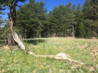
View from our campsite on night two. Camped on forest service road 19DC139.
DAY 1 - Crabtree Trailhead to Gem Lake (9 miles)
We packed up camp and drove down to Crabtree trailhead about 9:00am. As we arrived we meet a couple of cool guys who had just completed a 7-day 96 mile loop into the Emigrant Wilderness. A 96 mile trip in 7 days! I hope that one day I may be able to complete a trip like that.
Anyways, the trail starting out was very dusty but well covered. I assumed it was so dusty because of the large amounts of pack animals heading out from that trailhead.
After about two miles and passing multiple groups of boy scouts, we reached Camp Lake. It was a pretty lake that was tightly nestled along the trail. We didn't see many spots for camping but it would be a nice overnighter for anyone who is just beginning to experience the backcountry.

Wilderness boundary (Note: I took this on the way out because I didn't have good light to take a good pic of the sign on the way in).

View of Camp Lake from the trail
After a short descent to cross the outlet for Bear Lake the trail continued is gradual incline. We passed an unnamed pond before passing through Piute Meadow which was surrounded by spring water seeping out of the ground. I am not sure why but it makes me feel really good when I see a plethora of water bursting from the ground. It allows me to contemplate the aquifer system that fuels the beautiful scenery on our plane but yet we can only imagine the power and beauty of these underground water ways.

Unnamed pond filled with lily pads.

Looking back down on Puite Meadow
We continued hiking and passed Puite Lake. After passing this lake we came across the west fork of Cherry Creek. The water level was very low and easily passible. We thought this was a good location to take a break, eat some food and dip our feet in the nice cold water.
After lunch we filled up our water bottles and headed for Gem Lake. We arrived at the lake around 2:00pm and set up camp about 100 ft from the lake front. It was a beautiful lake and the weather was spectacular. It always feels good to wash up in cold lake water after a long and hot day of hiking.

Gem Lake in the late afternoon.
We were neighbors to a group of seven or so people who were affiliated with the boy scouts. It wasn't your typical boy scout trip though, just some well-behaved fisherman and two parents. We chatted for a bit about their trip thus far, hearing about some spectacular trout fishing, before we made some dinner and stoked our campfire.
DAY 2 - Gem Lake to Emigrant Lake (7.5 miles)
We awoke about 6:00am on day 2. While preparing our oatmeal we took in the beautiful scenery of Gem Lake and then hit the trail by 8:00am.
This day was probably the most spectacular view wise. We came upon numerous lakes and, in my opinion, each one was more beautiful then the last.

Jewelry Lake

Another view of Jewelry Lake

Deer Lake
in terms of hiking this was probably our easiest day. Not too much elevation gain and only about 7.5 miles. We saw quite a few people on the trail but most of them were heading out or at least back towards the trailhead. The trail was a little more exposed though so it did make the trek a hot one.

View of the well-maintained trail heading up to Buck Lakes.
After a short climb, Buck Lakes (at least the northern body of water) came into view. The lake was pretty well surrounded by old-growth pine and it was hard to grab a good picture of the lake but man, was it spectacular. We could see numerous spots along the lake that would make for good campsites for both large and small groups. I think if I were to return I would spend a night at Buck Lake.

First view of Buck Lakes (see Genesis in the left hand portion of the picture for perspective).
We took a snack break at the north end of the lake just before Buck Meadows. Probably the only time where we ran into more than one mosquito. It was a long trek through the dusty meadow but we soon came to a small creek where we filled up our water bottles before the long climb ahead.

View from Buck Meadows looking south towards Buck Lake

Another view looking south towards Buck Lake
The climb itself wasn't too bad in elevation but the switchbacks were insane. I appreciate the fact that switchbacks alleviate the rigors of steep elevation but they sure do add miles. And these were probably the most intense switchbacks I have experienced. haha. I couldn't tell where the trail was actually heading, we would be heading north for a quarter-mile before heading south for a quarter-mile. It was crazy. The climb ended at a pleasant little saddle that guarded the west entrance of the Emigrant Lake valley.

Saddle just before Emigrant Lake
Dropping down into the valley housing Emigrant Lake was spectacular. Emigrant is a huge lake and the trail runs parallel to the entire northern shore of the lake. The southern shore of the lake is locked by granite and highly exposed, we did not see any sites on that side of the lake. We proceeded to set up camp towards the northeastern end of the lake around noon. We only saw one other group camped nearby and they had been packed in by horses. They said they had been pulling out 20-inch trout from the lake, confirming our suspicions that this lake would have the best fishing in the area.
About 300 feet from our campsite we had a nice little sandy beach all to ourselves right on the lake. It was pleasant and the wind was light enough to just let you know that it was there. You cannot have fires within 0.5 miles of this lake, which is a bummer, so we enjoyed the beautiful scenery before we turned in early to listen to a podcast and fall asleep.

First good look at Emigrant Lake

View of the Lake from our campsite

A deer visiting our campsite (we would hear him biting our foldable bucket early the next morning)
DAY 3 - Emigrant Lake to Lower Relief Valley (11 miles)
After getting a poor night's sleep we got on the trail about 8:30am and headed up towards Mosquito Pass for an easy 600 foot climb. From my experience its not so much of a mountain pass as it is a long saddle. We didn't see any Mosquitos but man, was it pretty.

The bench/meadow before Mosquito Pass (seen in the upper left hand corner of the picture).

Another view looking towards Mosquito Pass
We also came across many pack trains on this section of the trip. It amazes me how these horses and mules are able to traverse these trails where at many times you are walking on precarious granite rocks! Pretty amazing animals.

Mosquito Pass

Looking down the valley towards the Kennedy Meadows junction. A long descent awaits.
After we passed the junction leading towards Relief Reservoir and Kennedy Meadows, we took a break at Summit Creek. From this point on we did not see anyone else until the following afternoon. The plan was to camp in Lower Relief Valley but we had trouble finding a spot. The creek beds were dry and the path was pretty overgrown. We continued to push up the valley past East Flange Rock where we came across an old cowboy camp near a small spring.
 View of East Flange Rock from camp
We set up camp late in the evening, made some dinner and sat around the fire till it got dark. Crossing Mosquito Pass you could really start to see the change in igneous rock. From the large granite behind the pass to the volcanic rock north of the pass (similar to the picture above). Throughout the night we could hear the bells of cattle off in the distant meadow.
DAY 4 - Relief Valley to Crabtree Trailhead (12 miles)
Woke up to a cool and crisp morning at our camp. We packed up and headed out for a short climb up into Upper Relief Valley. After seeing Lower Relief I wasn't expecting much but the scenery surprised me. Quite possibly the prettiest of the trip. There was a large campsite on the eastern end of the valley and had great views of the whole valley. The large ponds, sparkling creek and lively meadows was an amazing site. If I were to travel through the area again I would make a point to camp in Upper Relief.

Trail leading into Upper Relief Valley

Sparkling pond in the valley
After leaving the valley we wondered into familiar territory, Whitesides Meadows. A month earlier when we had hiked through this rather large and beautiful meadow the mosquitos were TERRIBLE. It was hard to even breath without inhaling them! As a side note, we bring along podcasts to listen to at night before we go to bed. And poor Genesis, since I have been downloading podcasts on parasitism (the study of parasites) she has been hyper-aware of parasites. Hearing all about insect vectors such as mosquitos makes the situation even more distasteful when you inhale them. But this time they were not even noticeable, the only animals we encountered was a small group of cows having a grand old time. They were not sure what to make of us.
 Trail leading into Whitesides Meadow
 Family of cows in the meadow
After leaving the meadows we ran into some fellow backpackers, the first we had seen in the last 24-hours. This was only surprising due to how packed the trailhead was and how many people we had encountered the previous days. We made a small climb up and over a mountain into Lake Valley where we reached the trail junction to Chewing Gum Lakes. I also noticed some interesting tracks on the path which I later confirmed to be mountain lion prints. Wish I would have grabbed a picture but I didn't. We ran into two rangers who checked our backcountry permits. We chatted for a few minutes before we went our separate ways. The last five miles of the day was on an unmaintained trail from Chewing Gum back to the trailhead. It involved about 1800 feet of elevation loss and was rather hot and exposed.
 View from the top of the mountain looking down on Lake Valley.

Heading to Chewing Gum Lakes

Chewing Gum Lakes
Chewing Gum Lakes involved a series of bodies of water that were seemingly interconnected. We were contemplating staying the night here but decided to head out the last 5 miles or so.
Right as we reached the trailhead we met an awesome retired couple. They were from the San Francisco (Bay) area but retired to Twain Harte in 2000. They said they hike in rain, snow or sunshine three times per week. What an amazing way to spend your time! Exploring the Sierras throughout the year is truly a way to live! They described various artifacts they had discovered while hiking off trail and gave us some great suggestions for trails and canyons to visit in the area. It seems as if every time we venture into the backcountry we meet some amazing people who are so kind and willing to spend time talking about the mountains.
When we reached the car it was quite hot and we headed down into Sonora for some cold beer and Olympics.
Summary: The Emigrant Wilderness in the Stanislaus National Forest is an incredible area that I would highly recommend to anyone wanting to visit. All the trails are easily accessible and well maintained. Whether you are backpacking in or being packed in on horses or mules, there are some amazing destinations.
There are plenty of campsites along Gem Lake but the better ones seem to be along the south end of the lake. There weren't too many sites at Emigrant Lake and you cannot have a campfire, which is kind of a bummer, but it is an incredible lake. I wouldn't recommend camping in Lower Relief Valley (unless there was a good spot we missed) but Upper Relief has some great spots. Lakes other than the ones we stayed at that I would highlight would be Deer Lake, Buck Lakes, Bigelow Lake (for the trout fishing) and Emigrant Meadow Lake.
We didn't encounter much in the way of wildlife, just a deer, osprey and chipmunks. When we left the trailhead the two guys who had just finished their trip famously said "there isn't a bear up there". I am sure there are bears in the area but we didn't see any sign of them. No tracks, torn logs or mention from any other hikers. Which is surprising to me.
We are still new to backpacking (picked it up about a year ago) but after spending about a month in the Sierras and the last year backpacking throughout southern California, we are hoping to get out into Colorado, Idaho or Wyoming to experience some more of the great backcountry that this nation has to offer.
Hope you enjoyed!
Background: As a science major I thrive on context. I guess backpacking is no different because I tend to look into the history of the area we plan to explore. It helps me appreciate the area more as I hike. In the case of the Emigrant Wilderness it was especially rewarding. Jedediah Smith is regarded as the first white man to cross the Sierra Nevada Mountains. Interestingly enough he first crossed them west-to-east near present day Ebbets Pass. The same area where the Miwok (native americans indigenous to the Stanislaus National Forest area) passed. Smith, in a way, set the stage for pioneer travel across the Sierras and into Sonora and the central valley. Many of the pioneers traveling to California in the 1850's traveled south, down the Walker River trail from Carson City and through present day Emigrant Wilderness into the Pinecrest and Sonora areas. In fact, Relief Valley was so named for the relief that Sonoran settlers would give the pioneers as they traveled towards their destination via the Emigrant Wilderness. Now that a bit of historical context has been lain, we can proceed :twothumbs:
<iframe width="100%" height="500px" src=" Click here to view on CalTopo"></iframe>
We drove up on August 3rd to pick up a permit at the ranger station in Pinecrest and camp two nights near the trailhead before heading out. We picked out a beautiful campsite at about 8,300 ft just west of the Gianelli trailhead.
We got to camp late on the 3rd and promptly set up before going to bed. The following morning we explored the area and followed the nearby creek downhill for awhile taking note of the pretty wildflowers and meadows.
Bell Creek running near Gianelli Trailhead
After a few hours of hiking and getting acclimated we headed back to camp for some dinner, campfire and nice view of the alpenglow.
View from our campsite on night two. Camped on forest service road 19DC139.
DAY 1 - Crabtree Trailhead to Gem Lake (9 miles)
We packed up camp and drove down to Crabtree trailhead about 9:00am. As we arrived we meet a couple of cool guys who had just completed a 7-day 96 mile loop into the Emigrant Wilderness. A 96 mile trip in 7 days! I hope that one day I may be able to complete a trip like that.
Anyways, the trail starting out was very dusty but well covered. I assumed it was so dusty because of the large amounts of pack animals heading out from that trailhead.
After about two miles and passing multiple groups of boy scouts, we reached Camp Lake. It was a pretty lake that was tightly nestled along the trail. We didn't see many spots for camping but it would be a nice overnighter for anyone who is just beginning to experience the backcountry.
Wilderness boundary (Note: I took this on the way out because I didn't have good light to take a good pic of the sign on the way in).
View of Camp Lake from the trail
After a short descent to cross the outlet for Bear Lake the trail continued is gradual incline. We passed an unnamed pond before passing through Piute Meadow which was surrounded by spring water seeping out of the ground. I am not sure why but it makes me feel really good when I see a plethora of water bursting from the ground. It allows me to contemplate the aquifer system that fuels the beautiful scenery on our plane but yet we can only imagine the power and beauty of these underground water ways.
Unnamed pond filled with lily pads.
Looking back down on Puite Meadow
We continued hiking and passed Puite Lake. After passing this lake we came across the west fork of Cherry Creek. The water level was very low and easily passible. We thought this was a good location to take a break, eat some food and dip our feet in the nice cold water.
After lunch we filled up our water bottles and headed for Gem Lake. We arrived at the lake around 2:00pm and set up camp about 100 ft from the lake front. It was a beautiful lake and the weather was spectacular. It always feels good to wash up in cold lake water after a long and hot day of hiking.
Gem Lake in the late afternoon.
We were neighbors to a group of seven or so people who were affiliated with the boy scouts. It wasn't your typical boy scout trip though, just some well-behaved fisherman and two parents. We chatted for a bit about their trip thus far, hearing about some spectacular trout fishing, before we made some dinner and stoked our campfire.
DAY 2 - Gem Lake to Emigrant Lake (7.5 miles)
We awoke about 6:00am on day 2. While preparing our oatmeal we took in the beautiful scenery of Gem Lake and then hit the trail by 8:00am.
This day was probably the most spectacular view wise. We came upon numerous lakes and, in my opinion, each one was more beautiful then the last.
Jewelry Lake
Another view of Jewelry Lake
Deer Lake
in terms of hiking this was probably our easiest day. Not too much elevation gain and only about 7.5 miles. We saw quite a few people on the trail but most of them were heading out or at least back towards the trailhead. The trail was a little more exposed though so it did make the trek a hot one.
View of the well-maintained trail heading up to Buck Lakes.
After a short climb, Buck Lakes (at least the northern body of water) came into view. The lake was pretty well surrounded by old-growth pine and it was hard to grab a good picture of the lake but man, was it spectacular. We could see numerous spots along the lake that would make for good campsites for both large and small groups. I think if I were to return I would spend a night at Buck Lake.
First view of Buck Lakes (see Genesis in the left hand portion of the picture for perspective).
We took a snack break at the north end of the lake just before Buck Meadows. Probably the only time where we ran into more than one mosquito. It was a long trek through the dusty meadow but we soon came to a small creek where we filled up our water bottles before the long climb ahead.
View from Buck Meadows looking south towards Buck Lake
Another view looking south towards Buck Lake
The climb itself wasn't too bad in elevation but the switchbacks were insane. I appreciate the fact that switchbacks alleviate the rigors of steep elevation but they sure do add miles. And these were probably the most intense switchbacks I have experienced. haha. I couldn't tell where the trail was actually heading, we would be heading north for a quarter-mile before heading south for a quarter-mile. It was crazy. The climb ended at a pleasant little saddle that guarded the west entrance of the Emigrant Lake valley.
Saddle just before Emigrant Lake
Dropping down into the valley housing Emigrant Lake was spectacular. Emigrant is a huge lake and the trail runs parallel to the entire northern shore of the lake. The southern shore of the lake is locked by granite and highly exposed, we did not see any sites on that side of the lake. We proceeded to set up camp towards the northeastern end of the lake around noon. We only saw one other group camped nearby and they had been packed in by horses. They said they had been pulling out 20-inch trout from the lake, confirming our suspicions that this lake would have the best fishing in the area.
About 300 feet from our campsite we had a nice little sandy beach all to ourselves right on the lake. It was pleasant and the wind was light enough to just let you know that it was there. You cannot have fires within 0.5 miles of this lake, which is a bummer, so we enjoyed the beautiful scenery before we turned in early to listen to a podcast and fall asleep.
First good look at Emigrant Lake
View of the Lake from our campsite
A deer visiting our campsite (we would hear him biting our foldable bucket early the next morning)
DAY 3 - Emigrant Lake to Lower Relief Valley (11 miles)
After getting a poor night's sleep we got on the trail about 8:30am and headed up towards Mosquito Pass for an easy 600 foot climb. From my experience its not so much of a mountain pass as it is a long saddle. We didn't see any Mosquitos but man, was it pretty.
The bench/meadow before Mosquito Pass (seen in the upper left hand corner of the picture).
Another view looking towards Mosquito Pass
We also came across many pack trains on this section of the trip. It amazes me how these horses and mules are able to traverse these trails where at many times you are walking on precarious granite rocks! Pretty amazing animals.
Mosquito Pass
Looking down the valley towards the Kennedy Meadows junction. A long descent awaits.
After we passed the junction leading towards Relief Reservoir and Kennedy Meadows, we took a break at Summit Creek. From this point on we did not see anyone else until the following afternoon. The plan was to camp in Lower Relief Valley but we had trouble finding a spot. The creek beds were dry and the path was pretty overgrown. We continued to push up the valley past East Flange Rock where we came across an old cowboy camp near a small spring.
View of East Flange Rock from campWe set up camp late in the evening, made some dinner and sat around the fire till it got dark. Crossing Mosquito Pass you could really start to see the change in igneous rock. From the large granite behind the pass to the volcanic rock north of the pass (similar to the picture above). Throughout the night we could hear the bells of cattle off in the distant meadow.
DAY 4 - Relief Valley to Crabtree Trailhead (12 miles)
Woke up to a cool and crisp morning at our camp. We packed up and headed out for a short climb up into Upper Relief Valley. After seeing Lower Relief I wasn't expecting much but the scenery surprised me. Quite possibly the prettiest of the trip. There was a large campsite on the eastern end of the valley and had great views of the whole valley. The large ponds, sparkling creek and lively meadows was an amazing site. If I were to travel through the area again I would make a point to camp in Upper Relief.
Trail leading into Upper Relief Valley
Sparkling pond in the valley
After leaving the valley we wondered into familiar territory, Whitesides Meadows. A month earlier when we had hiked through this rather large and beautiful meadow the mosquitos were TERRIBLE. It was hard to even breath without inhaling them! As a side note, we bring along podcasts to listen to at night before we go to bed. And poor Genesis, since I have been downloading podcasts on parasitism (the study of parasites) she has been hyper-aware of parasites. Hearing all about insect vectors such as mosquitos makes the situation even more distasteful when you inhale them. But this time they were not even noticeable, the only animals we encountered was a small group of cows having a grand old time. They were not sure what to make of us.
Trail leading into Whitesides Meadow Family of cows in the meadow After leaving the meadows we ran into some fellow backpackers, the first we had seen in the last 24-hours. This was only surprising due to how packed the trailhead was and how many people we had encountered the previous days. We made a small climb up and over a mountain into Lake Valley where we reached the trail junction to Chewing Gum Lakes. I also noticed some interesting tracks on the path which I later confirmed to be mountain lion prints. Wish I would have grabbed a picture but I didn't. We ran into two rangers who checked our backcountry permits. We chatted for a few minutes before we went our separate ways. The last five miles of the day was on an unmaintained trail from Chewing Gum back to the trailhead. It involved about 1800 feet of elevation loss and was rather hot and exposed.
View from the top of the mountain looking down on Lake Valley. Heading to Chewing Gum Lakes
Chewing Gum Lakes
Chewing Gum Lakes involved a series of bodies of water that were seemingly interconnected. We were contemplating staying the night here but decided to head out the last 5 miles or so.
Right as we reached the trailhead we met an awesome retired couple. They were from the San Francisco (Bay) area but retired to Twain Harte in 2000. They said they hike in rain, snow or sunshine three times per week. What an amazing way to spend your time! Exploring the Sierras throughout the year is truly a way to live! They described various artifacts they had discovered while hiking off trail and gave us some great suggestions for trails and canyons to visit in the area. It seems as if every time we venture into the backcountry we meet some amazing people who are so kind and willing to spend time talking about the mountains.
When we reached the car it was quite hot and we headed down into Sonora for some cold beer and Olympics.
Summary: The Emigrant Wilderness in the Stanislaus National Forest is an incredible area that I would highly recommend to anyone wanting to visit. All the trails are easily accessible and well maintained. Whether you are backpacking in or being packed in on horses or mules, there are some amazing destinations.
There are plenty of campsites along Gem Lake but the better ones seem to be along the south end of the lake. There weren't too many sites at Emigrant Lake and you cannot have a campfire, which is kind of a bummer, but it is an incredible lake. I wouldn't recommend camping in Lower Relief Valley (unless there was a good spot we missed) but Upper Relief has some great spots. Lakes other than the ones we stayed at that I would highlight would be Deer Lake, Buck Lakes, Bigelow Lake (for the trout fishing) and Emigrant Meadow Lake.
We didn't encounter much in the way of wildlife, just a deer, osprey and chipmunks. When we left the trailhead the two guys who had just finished their trip famously said "there isn't a bear up there". I am sure there are bears in the area but we didn't see any sign of them. No tracks, torn logs or mention from any other hikers. Which is surprising to me.
We are still new to backpacking (picked it up about a year ago) but after spending about a month in the Sierras and the last year backpacking throughout southern California, we are hoping to get out into Colorado, Idaho or Wyoming to experience some more of the great backcountry that this nation has to offer.
Hope you enjoyed!