- Joined
- Aug 9, 2007
- Messages
- 12,949
This is the first in a 3-part trip report from my backpacking trip through Llewellyn Gulch & Cottonwood Gulch in March 2013.
Part 1: Llewellyn Gulch
Part 2: Dos Tinajas
Part 3: Cottonwood Gulch
My stokeometer was off the charts leading into this trip. Nearly 4 months of little-to-no physical activity because of knee surgery had left my body weak, but my mind was starving for wilderness and this seemed like the perfect cure. To add to the stoke, it had been nearly two years since Taylor and I had backpacked together so I was excited to get out with an old friend. He's been living up in Logan going to school so it's been tough to get anything scheduled. It was Taylor who took me out on my first real backpack trip here in the Escalante almost exactly 10 years earlier. Just like old times!
We snuck out of town early on Wednesday and made it pretty far down Hole in the Rock Road before setting up camp just before dark. We had a pretty rowdy night around the fire which meant for a late, but very scenic start the next day.

After loading up our packs, we continued down Hole in the Rock Road to a small spur road where we parked my truck and started overland towards Fifty Mile Point. It was immediately clear how few people head out this way. We eventually found a faint cattle trail which we followed for about 2.4 miles to our drop in point at the top of South Fork Llewellyn Gulch.

The route we would be following on this trip is detailed in Steve Allen's Canyoneering 3 in Hike #27.
South Fork Llewellyn Gulch. Easily identified by the spring and troughs built into the wash where the trail meets it. This is the 3rd or 4th significant drainage that the cattle trail we were on skirts around. I've heard the North Fork is also very nice to descend but requires rappelling. We were anticipating some semi-technical canyoneering in South Fork but did not pack full technical gear.

In only a few minutes the canyon starts cutting into the Navajo Sandstone with little climbs and obstacles here and there.

The shallow upper slot was quite beautiful.

This was the first drop that we employed our handline. It was just a slightly awkward and exposed downclimb off the first drop for the first person. Easy to spot the rest though.

Soon after that we arrived at the biggest drop in South Fork Llewellyn. As I approached I saw some old webbing tied around an arch and started to wonder if I had made a mistake not packing the rope and harness. From the top of the chokestone, it looked like at least 20 feet down and pretty spicy. We rigged the handline into the existing webbing and I took a closer look.
I noticed a bit of a ledge down through an opening next to the chokestone so I climbed down onto it to get a better look at the rest of the climb. Going down!

Looking down from the small ledge. Once here, it's actually a pretty easy down climb, especially with the handline to get down a little lower where you can get under the chokestone. In retrospect I probably would have brought a little longer handline but it worked out fine.

Looking back up at the drop. I'm including lots of photos so people who aren't so comfortable with this kind of thing know what to expect. At least one member of any group heading down this canyon should be comfortable climbing up and down this kind of thing unprotected and the rest should be okay with handlining this kind of obstacle.


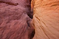
After that big drop, the slot went crazy. The colors were unreal in there. Reds, pinks, purples, peaches and white. Sometimes swirling, sometimes embedded with moki marbles, always exceptionally beautiful.

Handlining packs down another fairly large drop. This one looked pretty bad but it was leaned back enough that you could just jam into that crack and slide.

Taylor starting down the big slide. Having plenty of downclimbing experience is very helpful in this canyon.

We were continually blown away by what we found around each bend.


There were a lot of smaller but rather awkward downclimbs like this one. Sometimes we had to get out the handline, sometimes we didn't.


Another big drop. This one looked really sketchy at first but it was cake once you started lowering yourself down through a wormhole under the house-sized boulder.

It seemed like that slot went on for days. It relents a tiny bit here and there but for the most part it's solid narrows for several miles until the confluence with the north fork.

Right after the confluence water starts flowing and the canyon opens up a bit. Classic Escalante.

Taylor's chacos were pretty rough on his feet that day so we decided to setup camp near the exit route we would take the next day and just day hike further down the canyon. After hiking lower the next day, we were glad we camped here, it was one of the best spots in the canyon.

We had a mellow night out on the tarp. The weather was warm and the wind was calm. It was amazing to be out there again knowing we wouldn't be heading back for days.
The next morning we slept in pretty late again. We got our bags packed up and then left them near the exit and went on a stroll down canyon. It was well worth the time.

The light wasn't great but the scenery made up for it.


A choke point in the canyon made for a nice swim. This was avoidable but we didn't feel like backtracking to get around it.

A little further down we ran into some beaver dams at around the full pool elevation of Lake Powell. The sight of the dams made me not that stoked to see the lake so we decided to save our energy and head back to our packs so we could move on to the next camp.

On the way back up canyon, we found a very faint trail up on a bench that we followed back.

We found some nice rock art along the way. There was much more on this panel but it didn't photograph particularly well.

We made it back to our packs around noon and began the steep climb out onto the slickrock.

To be continued....
Part 1: Llewellyn Gulch
Part 2: Dos Tinajas
Part 3: Cottonwood Gulch
Part 1: Llewellyn Gulch
Part 2: Dos Tinajas
Part 3: Cottonwood Gulch
My stokeometer was off the charts leading into this trip. Nearly 4 months of little-to-no physical activity because of knee surgery had left my body weak, but my mind was starving for wilderness and this seemed like the perfect cure. To add to the stoke, it had been nearly two years since Taylor and I had backpacked together so I was excited to get out with an old friend. He's been living up in Logan going to school so it's been tough to get anything scheduled. It was Taylor who took me out on my first real backpack trip here in the Escalante almost exactly 10 years earlier. Just like old times!
We snuck out of town early on Wednesday and made it pretty far down Hole in the Rock Road before setting up camp just before dark. We had a pretty rowdy night around the fire which meant for a late, but very scenic start the next day.
After loading up our packs, we continued down Hole in the Rock Road to a small spur road where we parked my truck and started overland towards Fifty Mile Point. It was immediately clear how few people head out this way. We eventually found a faint cattle trail which we followed for about 2.4 miles to our drop in point at the top of South Fork Llewellyn Gulch.
The route we would be following on this trip is detailed in Steve Allen's Canyoneering 3 in Hike #27.
South Fork Llewellyn Gulch. Easily identified by the spring and troughs built into the wash where the trail meets it. This is the 3rd or 4th significant drainage that the cattle trail we were on skirts around. I've heard the North Fork is also very nice to descend but requires rappelling. We were anticipating some semi-technical canyoneering in South Fork but did not pack full technical gear.
In only a few minutes the canyon starts cutting into the Navajo Sandstone with little climbs and obstacles here and there.
The shallow upper slot was quite beautiful.
This was the first drop that we employed our handline. It was just a slightly awkward and exposed downclimb off the first drop for the first person. Easy to spot the rest though.
Soon after that we arrived at the biggest drop in South Fork Llewellyn. As I approached I saw some old webbing tied around an arch and started to wonder if I had made a mistake not packing the rope and harness. From the top of the chokestone, it looked like at least 20 feet down and pretty spicy. We rigged the handline into the existing webbing and I took a closer look.
I noticed a bit of a ledge down through an opening next to the chokestone so I climbed down onto it to get a better look at the rest of the climb. Going down!
Looking down from the small ledge. Once here, it's actually a pretty easy down climb, especially with the handline to get down a little lower where you can get under the chokestone. In retrospect I probably would have brought a little longer handline but it worked out fine.
Looking back up at the drop. I'm including lots of photos so people who aren't so comfortable with this kind of thing know what to expect. At least one member of any group heading down this canyon should be comfortable climbing up and down this kind of thing unprotected and the rest should be okay with handlining this kind of obstacle.
After that big drop, the slot went crazy. The colors were unreal in there. Reds, pinks, purples, peaches and white. Sometimes swirling, sometimes embedded with moki marbles, always exceptionally beautiful.
Handlining packs down another fairly large drop. This one looked pretty bad but it was leaned back enough that you could just jam into that crack and slide.
Taylor starting down the big slide. Having plenty of downclimbing experience is very helpful in this canyon.
We were continually blown away by what we found around each bend.
There were a lot of smaller but rather awkward downclimbs like this one. Sometimes we had to get out the handline, sometimes we didn't.
Another big drop. This one looked really sketchy at first but it was cake once you started lowering yourself down through a wormhole under the house-sized boulder.
It seemed like that slot went on for days. It relents a tiny bit here and there but for the most part it's solid narrows for several miles until the confluence with the north fork.
Right after the confluence water starts flowing and the canyon opens up a bit. Classic Escalante.
Taylor's chacos were pretty rough on his feet that day so we decided to setup camp near the exit route we would take the next day and just day hike further down the canyon. After hiking lower the next day, we were glad we camped here, it was one of the best spots in the canyon.
We had a mellow night out on the tarp. The weather was warm and the wind was calm. It was amazing to be out there again knowing we wouldn't be heading back for days.
The next morning we slept in pretty late again. We got our bags packed up and then left them near the exit and went on a stroll down canyon. It was well worth the time.
The light wasn't great but the scenery made up for it.
A choke point in the canyon made for a nice swim. This was avoidable but we didn't feel like backtracking to get around it.
A little further down we ran into some beaver dams at around the full pool elevation of Lake Powell. The sight of the dams made me not that stoked to see the lake so we decided to save our energy and head back to our packs so we could move on to the next camp.
On the way back up canyon, we found a very faint trail up on a bench that we followed back.
We found some nice rock art along the way. There was much more on this panel but it didn't photograph particularly well.
We made it back to our packs around noon and began the steep climb out onto the slickrock.
To be continued....
Part 1: Llewellyn Gulch
Part 2: Dos Tinajas
Part 3: Cottonwood Gulch
Attachments
Last edited:
 I don't know what the community is going to do about this...
 ")
