balzaccom
Member
- Joined
- Sep 30, 2014
- Messages
- 745
We spent Labor Day weekend hiking cross-country to Hyatt Lake in the Emigrant Wilderness--an adventure we're glad we did, but not one that we would recommend without reservation. It involved some basic topo map navigation, a certain amount of real effort, and just enough bushwhacking to keep many people from having a good time on a hike. If you ARE interested in going, we'll include a few tips at the end of this post to help you get past the more challenging parts.
The road to the Bourland Trailhead took us about 45 minutes from Long Barn, but the directions provided by the Stanislaus National Forest office where we got our permit were pretty darn good. And although the road is dirt for the last 8 or 9 miles, there are only two rough spots, in the first couple of miles of 30N16, that should make you slow down and ease over them. The trailhead has room for a few cars, but everyone else just parks alongside the road nearby, and the trail itself here is obvious and easy to follow.
For the first two miles the trail runs up to and then along the ridge--easy walking, although the forest limits your views. Then it drops down over the ridge and starts an easy downhill towards Cherry Creek. The only tricky part here is that there are at least two places where a massive tree has fallen across the trail---but it is not safe to assume the trail continues on the other side. Sometimes it takes a hard right turn away from the tree...
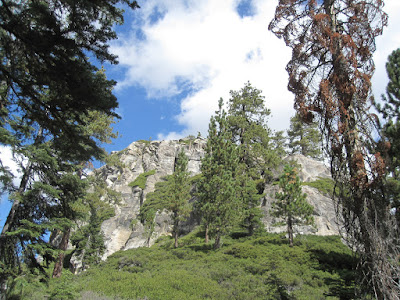
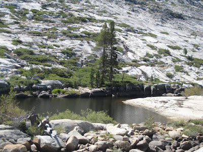
The trail runs down into Cherry Creek just west of a large granite knoll that is the end of the rocky part of the ridge on the topo map. That's it in the photo above.
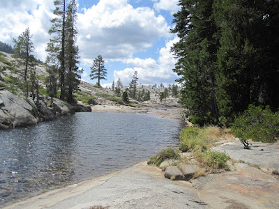
From here the trail drops pretty quickly, and within half a mile it breaks clear of the forest and opens up onto the massive granite cauldron that is Cherry Creek. The trail here is marked very frequently with cairns--which are completely unnecessary, since it's obvious that the route leads straight down to Cherry Creek. At this time of the year, the creek itself isn't flowing, but there was plenty of water in the isolated granite pools throughout the canyon. We stopped at one for lunch.
After lunch, the fun started. We headed up Cherry Creek to follow the large and obvious chute that leads up to the saddle below Hyatt Lake. The route was obvious, but the trail wasn't. We ended up trying to stay above most of the aspen thickets on the canyon floor by climbing the south side of the canyon---but occasionally ran into a cliff or a deep patch of manzanita, alders or aspen that slowed us down. Eventually we ended up in the bottom of the creek right at the foot of the dry waterfall where the chute empties into the canyon. From there a few cairns marked a route up out of the canyon and onto the chute, and the easiest part of the cross-country hiking began. Sure, it was uphill, but we were able to follow ledges and granite slopes all the way to the top of the saddle without any problems. That's the chute you want to follow, in the photo below.
Once at the saddle, we hiked along the ridge to the northeast until we found a clear set of ledges that would allow us to contour across to the obvious location of Hyatt Lake. In a couple of spots, usually marked by cairns, we had to hike down a short distance to land on another ledge that allowed us to continue our path...and the final one of these led down a very steep 8-10 foot crack into the manzanita right above the creek.
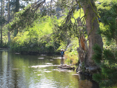
Here is where we went seriously wrong. We hiked up the creek itself to the outlet of the tiny lake just west of Hyatt. It involved some bushwhacking, but we felt pretty good that we were only about 300 yards from Hyatt Lake. But that little lake was a problem. The south shore was full of cliffs that looked impossible to climb. And the north shore was one huge patch of manzanita, alder, dogwood, ferns, and bush chinquapin. How bad could it be? It took us over half an hour to work through the 75 yards to the other end of tiny lake. P eventually had to rock climb a ridge to get through,. M chose the wiser path of taking off her shoes and simply wading through the shallows of the lake. Quite a mess. And in that thicket P lost both his whistle and an empty water bottle from his pack. M lost the water shoes that were strapped on the back. That's M wading in the lake below...
From the far side of this little lake, the hike to Hyatt was a piece of cake, and we landed on the nice sandy beach along the western shore. Because of the drought, the lake was quite low, and there was a clear "bathtub" ring around it about four feet high. In fact, if the lake had been full, our nice sandy beach would have been mainly under water.
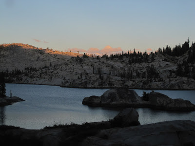
We set up camp and spent the rest of the afternoon and evening exploring the shores of Hyatt Lake...noting the even larger beach at the other end, as well as a few campsites along the north shore. The south shore is pretty steep--with no obvious campsites there. As evening fell, the lake was simply beautiful...as in the photo above.
So on the way out, decided to find an easier route. Sure, we could have tackled that thicket again, and maybe even found our missing equipment, but just as likely we would have lost more...
So we stayed on the cliffs above the other side of the smaller lake. There was a clear trail in this direction from Hyatt Lake, and we followed it to the far end of the little lake, and beyond. And we didn't see any way down from the cliffs. After wandering around for about twenty minutes, P finally found a route down--more or less across from the steep crack we'd descended to get down to the creek on the other side...and we were good to go.
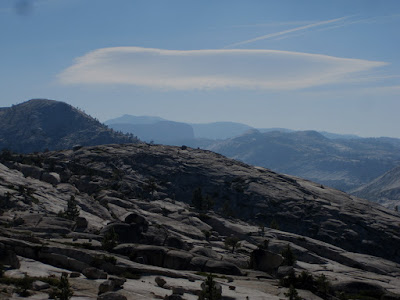
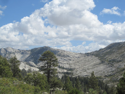
The route contouring back across to the saddle was now familiar territory, and we enjoyed the views of Cherry Canyon here. That's one view above.
We eventually worked our way back down the granite chute to Cherry Canyon. This time we were determined to avoid the manzanita and aspen thickets, and so we crossed the chute directly below that last waterfall. It worked great, and we hiked along the granite ridge on the north side of the creek for a while. When that ridge gave out, we crossed over the creek and headed directly into the forested part of the canyon. Hiking here was a lot easier than on the granite above, and we found our way back to that first deep pool, where we ate lunch again. Along the way, we passed three groups of four hikers each, all headed towards Hyatt Lake.
From the pool it was a stroll in the park back up the granite to the trail, and then back along the trail to the car.
IF YOU GO: There are a couple of key points in this trail that make a big difference,. From that first pool, the best route runs right up the right-hand (southern) side of the creek until you can get into the forest. Once in this grove of larger trees, the hiking is easy. Just where the forest ends, you'll need to push through an aspen thicket to get to the granite above the creek at this point---but stay close to the creek. If you can, cross back over to the north side where possible and then hike the granite ridge up to the chute. But that's not the really important one.
The Really Big Clue: when you downclimb that crack into the creek just below the smaller lake below Hyatt, only hike about 25-40 feet along the southern side of that little creek, then find a route through the manzanita to get up on the cliffs above the southern side of the creek. Once there, it's easy to find a route over the tops of the cliffs to Hyatt Lake.
Or you can try to bushwhack through the thickets of manzanita and chinquapin on the other side of that lake. If you do, we'd appreciate it if you would look for P's whistle, our platypus folding bottle, and M's brand new water sandals...sigh.
More importantly, there are at least two other routes to Hyatt Lake. One is to hike to Pingree or Resasco Lake and then follow the canyon down to Hyatt. The other is to hike up the larger Cherry Creek (avoiding the chute we climbed) and then climbing the granite on the backside of the ridge to the northwest of Hyatt Lake. And that route is also possible from Chain Lakes...
All of those seem easier than the route we took. But we haven't hiked them. The maps always make the routes seem possible...even when they aren't!
Featured image for home page:

The road to the Bourland Trailhead took us about 45 minutes from Long Barn, but the directions provided by the Stanislaus National Forest office where we got our permit were pretty darn good. And although the road is dirt for the last 8 or 9 miles, there are only two rough spots, in the first couple of miles of 30N16, that should make you slow down and ease over them. The trailhead has room for a few cars, but everyone else just parks alongside the road nearby, and the trail itself here is obvious and easy to follow.
For the first two miles the trail runs up to and then along the ridge--easy walking, although the forest limits your views. Then it drops down over the ridge and starts an easy downhill towards Cherry Creek. The only tricky part here is that there are at least two places where a massive tree has fallen across the trail---but it is not safe to assume the trail continues on the other side. Sometimes it takes a hard right turn away from the tree...
The trail runs down into Cherry Creek just west of a large granite knoll that is the end of the rocky part of the ridge on the topo map. That's it in the photo above.
From here the trail drops pretty quickly, and within half a mile it breaks clear of the forest and opens up onto the massive granite cauldron that is Cherry Creek. The trail here is marked very frequently with cairns--which are completely unnecessary, since it's obvious that the route leads straight down to Cherry Creek. At this time of the year, the creek itself isn't flowing, but there was plenty of water in the isolated granite pools throughout the canyon. We stopped at one for lunch.
After lunch, the fun started. We headed up Cherry Creek to follow the large and obvious chute that leads up to the saddle below Hyatt Lake. The route was obvious, but the trail wasn't. We ended up trying to stay above most of the aspen thickets on the canyon floor by climbing the south side of the canyon---but occasionally ran into a cliff or a deep patch of manzanita, alders or aspen that slowed us down. Eventually we ended up in the bottom of the creek right at the foot of the dry waterfall where the chute empties into the canyon. From there a few cairns marked a route up out of the canyon and onto the chute, and the easiest part of the cross-country hiking began. Sure, it was uphill, but we were able to follow ledges and granite slopes all the way to the top of the saddle without any problems. That's the chute you want to follow, in the photo below.
Once at the saddle, we hiked along the ridge to the northeast until we found a clear set of ledges that would allow us to contour across to the obvious location of Hyatt Lake. In a couple of spots, usually marked by cairns, we had to hike down a short distance to land on another ledge that allowed us to continue our path...and the final one of these led down a very steep 8-10 foot crack into the manzanita right above the creek.
Here is where we went seriously wrong. We hiked up the creek itself to the outlet of the tiny lake just west of Hyatt. It involved some bushwhacking, but we felt pretty good that we were only about 300 yards from Hyatt Lake. But that little lake was a problem. The south shore was full of cliffs that looked impossible to climb. And the north shore was one huge patch of manzanita, alder, dogwood, ferns, and bush chinquapin. How bad could it be? It took us over half an hour to work through the 75 yards to the other end of tiny lake. P eventually had to rock climb a ridge to get through,. M chose the wiser path of taking off her shoes and simply wading through the shallows of the lake. Quite a mess. And in that thicket P lost both his whistle and an empty water bottle from his pack. M lost the water shoes that were strapped on the back. That's M wading in the lake below...
From the far side of this little lake, the hike to Hyatt was a piece of cake, and we landed on the nice sandy beach along the western shore. Because of the drought, the lake was quite low, and there was a clear "bathtub" ring around it about four feet high. In fact, if the lake had been full, our nice sandy beach would have been mainly under water.
We set up camp and spent the rest of the afternoon and evening exploring the shores of Hyatt Lake...noting the even larger beach at the other end, as well as a few campsites along the north shore. The south shore is pretty steep--with no obvious campsites there. As evening fell, the lake was simply beautiful...as in the photo above.
So on the way out, decided to find an easier route. Sure, we could have tackled that thicket again, and maybe even found our missing equipment, but just as likely we would have lost more...
So we stayed on the cliffs above the other side of the smaller lake. There was a clear trail in this direction from Hyatt Lake, and we followed it to the far end of the little lake, and beyond. And we didn't see any way down from the cliffs. After wandering around for about twenty minutes, P finally found a route down--more or less across from the steep crack we'd descended to get down to the creek on the other side...and we were good to go.
The route contouring back across to the saddle was now familiar territory, and we enjoyed the views of Cherry Canyon here. That's one view above.
We eventually worked our way back down the granite chute to Cherry Canyon. This time we were determined to avoid the manzanita and aspen thickets, and so we crossed the chute directly below that last waterfall. It worked great, and we hiked along the granite ridge on the north side of the creek for a while. When that ridge gave out, we crossed over the creek and headed directly into the forested part of the canyon. Hiking here was a lot easier than on the granite above, and we found our way back to that first deep pool, where we ate lunch again. Along the way, we passed three groups of four hikers each, all headed towards Hyatt Lake.
From the pool it was a stroll in the park back up the granite to the trail, and then back along the trail to the car.
IF YOU GO: There are a couple of key points in this trail that make a big difference,. From that first pool, the best route runs right up the right-hand (southern) side of the creek until you can get into the forest. Once in this grove of larger trees, the hiking is easy. Just where the forest ends, you'll need to push through an aspen thicket to get to the granite above the creek at this point---but stay close to the creek. If you can, cross back over to the north side where possible and then hike the granite ridge up to the chute. But that's not the really important one.
The Really Big Clue: when you downclimb that crack into the creek just below the smaller lake below Hyatt, only hike about 25-40 feet along the southern side of that little creek, then find a route through the manzanita to get up on the cliffs above the southern side of the creek. Once there, it's easy to find a route over the tops of the cliffs to Hyatt Lake.
Or you can try to bushwhack through the thickets of manzanita and chinquapin on the other side of that lake. If you do, we'd appreciate it if you would look for P's whistle, our platypus folding bottle, and M's brand new water sandals...sigh.
More importantly, there are at least two other routes to Hyatt Lake. One is to hike to Pingree or Resasco Lake and then follow the canyon down to Hyatt. The other is to hike up the larger Cherry Creek (avoiding the chute we climbed) and then climbing the granite on the backside of the ridge to the northwest of Hyatt Lake. And that route is also possible from Chain Lakes...
All of those seem easier than the route we took. But we haven't hiked them. The maps always make the routes seem possible...even when they aren't!
Featured image for home page: