- Joined
- Dec 7, 2017
- Messages
- 264
September 30 - October 3, 2019
This little adventure into Beef Basin has been on our radar screen for quite some time, starting from when we first saw IntrepidXJ's beautifully crafted visual storytelling of the area. Thanks for the inspiration! However, one thing or another (other hiking commitments, our move from AZ to CO, family obligations, weather, etc.) kept getting in the way. Finally (!), we were able to pull it off. I thought I'd share some insights and information on the area for others who might never have heard of the place or for those perhaps intimidated by the remoteness and/or lack of solid info out there on the web.
Beef Basin.....What is it? The basin is just that - a wide, open basin that once served as the winter home to cattle ranched in the area. Hence, the name. A long time before cattle roamed the area, however, ancient peoples lived, farmed and hunted there as well as in the several canyons that drain into Beef Basin Wash. The remains of their homes, granaries, pieces of artifacts, and some rock art are still there for viewing. I've read somewhere that it was once more densely populated than Montezuma Canyon to the east as well as more populated than Canyon of the Ancients, but who really knows for sure. Suffice it to say that there's a lot to see in Beef Basin, with some sites right in the open with minimal effort required to approach and some sites far more hidden and challenging to get to.
Where is it?.....Get out your map of Canyonlands, and the Needles District in particular. See that far left triangular section of Needles that is bound to the west by the mighty Colorado and to the south by the Dark Canyon Primitive Area and the Butler Wash Wilderness Study Area? That's all BLM land and if you go a little further south you'll see Beef Basin, Ruin Park, Middle Park, and the canyons coming in from the south (Sweet Alice, South, Ruin, and Calf). These canyons dump into Beef Basin Wash, which then drains into Gypsum canyon to the west, and then finally into the Colorado at Cataract Canyon. This is your playground!
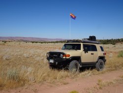
What to expect.....This place is remote. Not as remote as, say, the Dollhouse in the Maze, but it was a 3-hour off-pavement drive on Elk Ridge Road from Blanding. I didn't pay careful attention to the clock when we left via Beef Basin Road (107) to 211 east to 191 north, but I'd say it was at least a 4-hour drive to Moab. I should also say that the road conditions are presently such that a regular-clearance, 2WD car could make the same drive that we did and could drive the "main" roads within Beef Basin. Getting into the side canyons, though, requires a high-clearance 4WD vehicle and you'd better be mentally prepared for deep desert pinstriping! All this can easily change, though, with rain or snow so check with the proper authorities as to road conditions before heading out. Also, this place is not heavily visited. We saw only 3 other vehicles while we were there and saw no one else camping. Self-sufficiency is required. I believe there are a few perennial springs, but didn't investigate this point since we carry in all the water we need.
Blake and I tend to seek out the more obscure, lesser known sites so you won't see pictures of the commonly-visited ruins. Plenty of photos of those sites are available at various websites, often posted by off-roading groups. Anyway, below is a smattering of what we saw.
Oh, and I should add that Blake thought is was "One of the most beautiful places that we've been to".
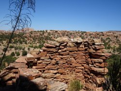
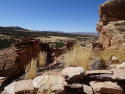
This ruin was built atop a small butte at three different elevations. I climbed up to the tip-top of the butte and found only faint walls and a few timbers. Below are photos of the views seen from the middle elevation:
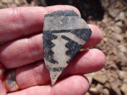
An example of the ornately painted sherds that we found at the site:
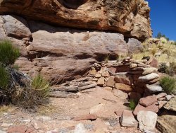
A small room at the lowest level is still hangin' in there:
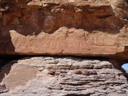
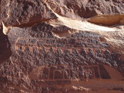
A petroglyph panel at the same site. Note that in all my research I found scant mention of rock art in Beef Basin:
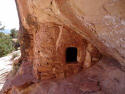
From our campsite in Middle Park we could see three granaries:
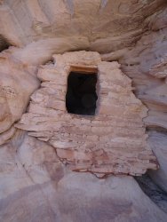
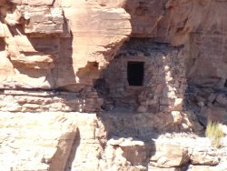
This is actually a three-room granary "complex", but I wasn't the best photographer and only captured the largest room of the three. Below the right, bottom of the granary are three moki steps not visible in the photo:
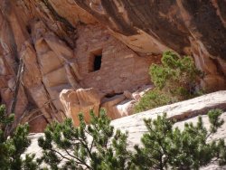
The third granary with it's opening facing away from viewing eyes down below:
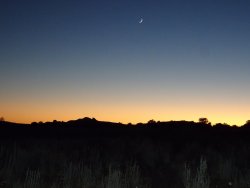
Sunset, shortly before the milky way and twinkling stars starting popping out across the sky:
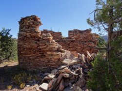
I found this large circular ruin a couple weeks back using sat imagery and Blake and I struck out cross-country to find it. Other than a single set of ATV tracks up the wash, we saw only 3 bootprints right where the ATV had stopped. So, this site doesn't appear to be visited often, if rarely at all. The ruin itself is 14 - 15 feet in diameter and about 16 feet tall. It had a doorway below and one up above. However, there were no timbers at the site nor were there obvious "holes" in the walls where the missing timbers would have been placed to make a roof/floor. There were no soot marks on the walls and a complete lack of sherds or chert at the site and the surrounding area. I even checked out nearby watercourses to see if something had been exposed by precip from earlier this year and I hunted around for a midden. No luck. If the structure had never really been inhabited or used, that could explain the lack of artifacts on the ground. But, then, why go to all that trouble of making a second story if it were only temporary shelter?? I started to think that perhaps ranch-hands might have built it as some sort of shelter, but they wouldn't have constructed such short doorways (I had to take off my pack and crawl through on my hands and knees) and I'd think there would have been old cans and bottles scattered around. To my untrained eyes it didn't appear that the site had been excavated and I certainly didn't read of any excavations in this drainage. I'm perplexed.....
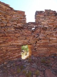
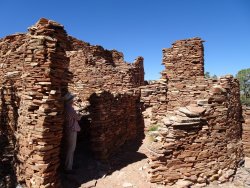
Later in the day we hiked up to a second ruin that was far more extensive and offered great views into the canyon down below. While most of the stonework lacked mortar (as do many in the Beef Basin area), this one did have some mortar on the interior of some of the rooms:
A granary across a side canyon from the multi-room dwelling:
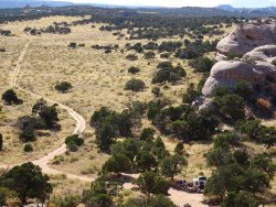
At the end of the day I scrambled up on the cliffs surrounding Middle Park and took this photo that gives you a sense of the basin. Scattered throughout are small, medium and large buttes that may or may not contain secrets! :
And here's a second photo to give you a feel for the basin and the surrounding area :
The next day we went in search of a great rock art panel (thanks to the kind help of a friend). As per usual, there was no trail, and there's no bee-lining. Except when down in the basin itself, the hiking is up and down, over or around obstacles, and so forth. Each mile seems like 1.5 times it's actual length. Even so, we were not disappointed by the panel and equally pleased with the views from the site. Great place for the ancients to hang out, catch up with friends, try their hand at carving into sandstone, and relaxing. :
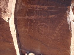
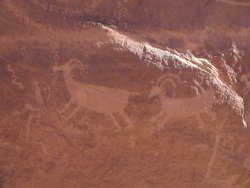
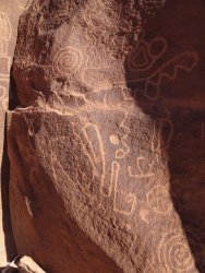
On the way to the panel were wide swaths of dark red, glossy stone (sorry, I'm not a geologist) which I assume served as a sort of quarry for prehistoric point producers:
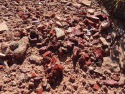
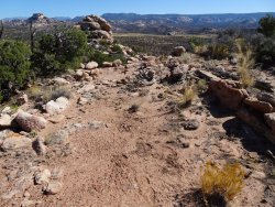
That afternoon we struck out for what I was calling "Udink's Ruin" as he's the one who spotted it with sat imagery and tipped me off as to its location. There wasn't much left of the walls except for one or two courses of stone. However, there was an abundance of pottery pieces (of at least four different kinds with black-on-white being the most prevalent) and plenty of worked stone. I noticed, too, just below the butte-top ruin was a very level flat area devoid of vegetation. It reminded me of what is assumed to be a dance plaza at a great house site outside of Blanding. For us the most remarkable thing about this site were the phenomenal views of the La Sals, the Henry's, and the Abajo's! We ran out of time to check out the nearby alcove, so I'll leave that to Udink to "discover".
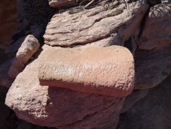
A broken mano :
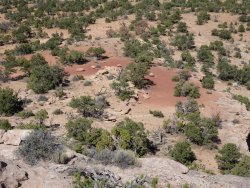
Dance plaza, play area ??
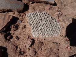
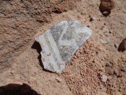
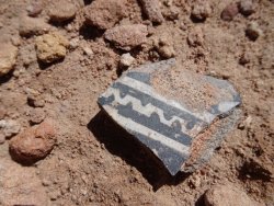
A sampling of the sherds we found on the ground :
All-in-all, we enjoyed the solitude of Beef Basin and the knowledge that there's more than enough left for us to explore to keep us coming back again. And again. And again.
This little adventure into Beef Basin has been on our radar screen for quite some time, starting from when we first saw IntrepidXJ's beautifully crafted visual storytelling of the area. Thanks for the inspiration! However, one thing or another (other hiking commitments, our move from AZ to CO, family obligations, weather, etc.) kept getting in the way. Finally (!), we were able to pull it off. I thought I'd share some insights and information on the area for others who might never have heard of the place or for those perhaps intimidated by the remoteness and/or lack of solid info out there on the web.
Beef Basin.....What is it? The basin is just that - a wide, open basin that once served as the winter home to cattle ranched in the area. Hence, the name. A long time before cattle roamed the area, however, ancient peoples lived, farmed and hunted there as well as in the several canyons that drain into Beef Basin Wash. The remains of their homes, granaries, pieces of artifacts, and some rock art are still there for viewing. I've read somewhere that it was once more densely populated than Montezuma Canyon to the east as well as more populated than Canyon of the Ancients, but who really knows for sure. Suffice it to say that there's a lot to see in Beef Basin, with some sites right in the open with minimal effort required to approach and some sites far more hidden and challenging to get to.
Where is it?.....Get out your map of Canyonlands, and the Needles District in particular. See that far left triangular section of Needles that is bound to the west by the mighty Colorado and to the south by the Dark Canyon Primitive Area and the Butler Wash Wilderness Study Area? That's all BLM land and if you go a little further south you'll see Beef Basin, Ruin Park, Middle Park, and the canyons coming in from the south (Sweet Alice, South, Ruin, and Calf). These canyons dump into Beef Basin Wash, which then drains into Gypsum canyon to the west, and then finally into the Colorado at Cataract Canyon. This is your playground!
What to expect.....This place is remote. Not as remote as, say, the Dollhouse in the Maze, but it was a 3-hour off-pavement drive on Elk Ridge Road from Blanding. I didn't pay careful attention to the clock when we left via Beef Basin Road (107) to 211 east to 191 north, but I'd say it was at least a 4-hour drive to Moab. I should also say that the road conditions are presently such that a regular-clearance, 2WD car could make the same drive that we did and could drive the "main" roads within Beef Basin. Getting into the side canyons, though, requires a high-clearance 4WD vehicle and you'd better be mentally prepared for deep desert pinstriping! All this can easily change, though, with rain or snow so check with the proper authorities as to road conditions before heading out. Also, this place is not heavily visited. We saw only 3 other vehicles while we were there and saw no one else camping. Self-sufficiency is required. I believe there are a few perennial springs, but didn't investigate this point since we carry in all the water we need.
Blake and I tend to seek out the more obscure, lesser known sites so you won't see pictures of the commonly-visited ruins. Plenty of photos of those sites are available at various websites, often posted by off-roading groups. Anyway, below is a smattering of what we saw.
Oh, and I should add that Blake thought is was "One of the most beautiful places that we've been to".
This ruin was built atop a small butte at three different elevations. I climbed up to the tip-top of the butte and found only faint walls and a few timbers. Below are photos of the views seen from the middle elevation:


An example of the ornately painted sherds that we found at the site:

A small room at the lowest level is still hangin' in there:

A petroglyph panel at the same site. Note that in all my research I found scant mention of rock art in Beef Basin:

From our campsite in Middle Park we could see three granaries:

This is actually a three-room granary "complex", but I wasn't the best photographer and only captured the largest room of the three. Below the right, bottom of the granary are three moki steps not visible in the photo:

The third granary with it's opening facing away from viewing eyes down below:

Sunset, shortly before the milky way and twinkling stars starting popping out across the sky:

I found this large circular ruin a couple weeks back using sat imagery and Blake and I struck out cross-country to find it. Other than a single set of ATV tracks up the wash, we saw only 3 bootprints right where the ATV had stopped. So, this site doesn't appear to be visited often, if rarely at all. The ruin itself is 14 - 15 feet in diameter and about 16 feet tall. It had a doorway below and one up above. However, there were no timbers at the site nor were there obvious "holes" in the walls where the missing timbers would have been placed to make a roof/floor. There were no soot marks on the walls and a complete lack of sherds or chert at the site and the surrounding area. I even checked out nearby watercourses to see if something had been exposed by precip from earlier this year and I hunted around for a midden. No luck. If the structure had never really been inhabited or used, that could explain the lack of artifacts on the ground. But, then, why go to all that trouble of making a second story if it were only temporary shelter?? I started to think that perhaps ranch-hands might have built it as some sort of shelter, but they wouldn't have constructed such short doorways (I had to take off my pack and crawl through on my hands and knees) and I'd think there would have been old cans and bottles scattered around. To my untrained eyes it didn't appear that the site had been excavated and I certainly didn't read of any excavations in this drainage. I'm perplexed.....


Later in the day we hiked up to a second ruin that was far more extensive and offered great views into the canyon down below. While most of the stonework lacked mortar (as do many in the Beef Basin area), this one did have some mortar on the interior of some of the rooms:

A granary across a side canyon from the multi-room dwelling:

At the end of the day I scrambled up on the cliffs surrounding Middle Park and took this photo that gives you a sense of the basin. Scattered throughout are small, medium and large buttes that may or may not contain secrets! :

And here's a second photo to give you a feel for the basin and the surrounding area :

The next day we went in search of a great rock art panel (thanks to the kind help of a friend). As per usual, there was no trail, and there's no bee-lining. Except when down in the basin itself, the hiking is up and down, over or around obstacles, and so forth. Each mile seems like 1.5 times it's actual length. Even so, we were not disappointed by the panel and equally pleased with the views from the site. Great place for the ancients to hang out, catch up with friends, try their hand at carving into sandstone, and relaxing. :


On the way to the panel were wide swaths of dark red, glossy stone (sorry, I'm not a geologist) which I assume served as a sort of quarry for prehistoric point producers:

That afternoon we struck out for what I was calling "Udink's Ruin" as he's the one who spotted it with sat imagery and tipped me off as to its location. There wasn't much left of the walls except for one or two courses of stone. However, there was an abundance of pottery pieces (of at least four different kinds with black-on-white being the most prevalent) and plenty of worked stone. I noticed, too, just below the butte-top ruin was a very level flat area devoid of vegetation. It reminded me of what is assumed to be a dance plaza at a great house site outside of Blanding. For us the most remarkable thing about this site were the phenomenal views of the La Sals, the Henry's, and the Abajo's! We ran out of time to check out the nearby alcove, so I'll leave that to Udink to "discover".

A broken mano :

Dance plaza, play area ??

A sampling of the sherds we found on the ground :


All-in-all, we enjoyed the solitude of Beef Basin and the knowledge that there's more than enough left for us to explore to keep us coming back again. And again. And again.
