- Joined
- Aug 9, 2007
- Messages
- 12,949
This is the second in a 3-part trip report from my backpacking trip through Llewellyn Gulch & Cottonwood Gulch in March 2013.
Part 1: Llewellyn Gulch
Part 2: Dos Tinajas
Part 3: Cottonwood Gulch
After exploring down into lower Llewellyn Gulch, we made our way back to our packs and started up the exit. We didn't have much information on it and as is to be expected in this area, there were no cairns. Sweet!!
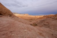
The climb out was pretty easy with one spot where it was easiest to toss our packs up onto a ledge and then climb up. Pretty much all class 3 except that tiny spot. We took our time, admiring the views back into Llewellyn Gulch as it appeared to get swallowed whole by a sea of swirling navajo sandstone.


Once we were onto the bench, we were stunned at how much more dramatic the topography was than we had expected. Looking at topos and satellite views it's easy to think you could almost just walk in a semi-straight line across the bench. What we found were huge domes one after another, making navigation and hiking in general, significantly more difficult than we had anticipated. Especially with about 18 pounds of water in each of our packs.

We were hoping to see water in potholes as we hiked. A sign that we would likely find water in some potholes near a point named Kirstein that we were headed towards. Giant dry potholes like this were not encouraging to see.

We hiked on, finding our way amongst the domes, occasionally checking our path against the approximate location of Kirstein; the highest dome on the bench. At the top of the dome there is a rock cairn and the name 'Kirstein' carved into the rock. From there we hoped to climb part way (or all the way) down to Lake Powell to camp.

Notice Taylor in the middle of this photo looking for a route up.

The sun finally came out and gave us a spectacular view of the terrain we had covered so far that day.

After cresting another tall pass, we took a breather where I realized I was already needing to cut into my water reserves for the potential dry camp. This was particularly concerning because we had now walked several miles through the slickrock passing countless potholes that looked like they often held water but had only seen one tiny puddle in that time. Add to that the fact that I'm starting to feel pretty weak from the whole knee surgery/no hiking regimen I've been on and I was really starting to wonder what the next 24 hours were going to be like.
As we crested another dome, I got out the GPS to get a line on where to head next. As I looked at the screen, I rolled my bad ankle and hit the ground hard. The GPS went flying and I ended up on the ground in quite a bit of pain. SHIT. At this point we're probably 13 miles or more into this trip. I have a knee that is still only half healed and hurting quite a bit from all the hiking, and now I have an ankle on the other leg that doesn't want to cooperate.
I was hot, thirsty and very tired, but there were no options. We needed water and there certainly wasn't any around here. So we hiked on. The steep slopes crossing through the sandstone were pretty difficult with my new injury. I could get a handful of steps in without too much pain, but then it would hit just right and I'd about drop to the ground again. Like it would strike a nerve almost.
As we crested into a small valley, I saw a tiny bit of shade in a small side canyon between two large domes to the south. This was the first good shade we'd seen in a long time so we decided to head for it and rest my foot and conserve our sweat until it cooled down a bit.
As we approached the small canyon, we saw a few potholes in the watercourse. Dry.. dry... dry.. WET!!! At the base of this tiny drainage, probably no more than 100 yards from the top, were two tiny potholes full of water. One was probably only a couple of cubic feet, the other quite a bit larger and nearly full. Amazing! Just 50 or so feet past the tinajas, the shaded area turned out to be a wonderful flat ledge with a small cave. We dropped our packs and I laid down. Taylor made some tea, we talked about our options. We would stay here tonight and let my ankle rest. I decided we should call this place 'Dos Tinajas'. What a magical place.
This shot is from a bit later in the afternoon, but you can see our little campsite on the ledge in the distance.

After getting settled in, we climbed the dome to the east of us to see what we could see. The views were amazing!

Looking north towards Escalante and Hole in the Rock Road

A not-so-great group shot. Should have brought my tripod up from camp!

Climbing back down to camp with Navajo Mountain towering in the distance.

Precious water...

Taylor sitting near camp enjoying the evening light

It was an extraordinarily windy night out there on the rock. Neither of us had tents, just my backpacking tarp to share. The wind was so bad that we had to tie things down. Bags to pads, pads to rocks, everything else in the packs! After it got dark it really got insane out there. There wasn't much sand around us but every gust would still clobber us with it. Thankfully, it calmed down later in the night and we were able to get some decent sleep.
The view from inside my sleeping bag that morning.

It was totally overcast in the morning, but the sun still poked through the clouds a bit. The low light on Fifty Mile Point was beautiful. This is the only shot I really took with my new 45mm 1.8.

Taylor stoked at Dos Tinajas

We thought a lot about our options for this day. We had water now, so we could easily continue on to Kirstein and get a great view into the Lake. But wait... I hate that stinky lake.. why would I want to see it? Hehe. Okay really, what made us decide to head for Cottonwood Gulch instead of Kirstein was my ankle and my increasingly stiff knee. The ankle was feeling quite a bit better in the morning but I didn't feel like pushing my luck by hiking even further away from safety. So we packed up and started out across the slickrock again, but this time south towards the rim of Cottonwood Gulch.

The terrain on the south side of the bench was even bigger than on the north side. There are two pretty large drainages to cross and then we would follow the rim to the entrance point high in Cottonwood Gulch.
Looking down into the second big drainage. It was amazing how it was actually pretty easy to travel through this even though the terrain seemed bigger.

We found a lot more water on this side of the bench. Very large and very deep potholes. If we had hiked this way the day before, we would have been loving life.

The rim of Cottonwood Gulch. Getting close to the entrance.

Scouting out the best route into the large drainage that we use to get into Cottonwood

The story of the last 24 hours in one photo...

The sun came out for us as we descended into Cottonwood Gulch. And the potholes continued, this time they continued in a long string all the way to the bottom of the canyon, even cutting down into a short technical slot full of serious keeper potholes.

Cottonwood Gulch

To be continued...
Part 1: Llewellyn Gulch
Part 2: Dos Tinajas
Part 3: Cottonwood Gulch
Part 1: Llewellyn Gulch
Part 2: Dos Tinajas
Part 3: Cottonwood Gulch
After exploring down into lower Llewellyn Gulch, we made our way back to our packs and started up the exit. We didn't have much information on it and as is to be expected in this area, there were no cairns. Sweet!!
The climb out was pretty easy with one spot where it was easiest to toss our packs up onto a ledge and then climb up. Pretty much all class 3 except that tiny spot. We took our time, admiring the views back into Llewellyn Gulch as it appeared to get swallowed whole by a sea of swirling navajo sandstone.
Once we were onto the bench, we were stunned at how much more dramatic the topography was than we had expected. Looking at topos and satellite views it's easy to think you could almost just walk in a semi-straight line across the bench. What we found were huge domes one after another, making navigation and hiking in general, significantly more difficult than we had anticipated. Especially with about 18 pounds of water in each of our packs.
We were hoping to see water in potholes as we hiked. A sign that we would likely find water in some potholes near a point named Kirstein that we were headed towards. Giant dry potholes like this were not encouraging to see.
We hiked on, finding our way amongst the domes, occasionally checking our path against the approximate location of Kirstein; the highest dome on the bench. At the top of the dome there is a rock cairn and the name 'Kirstein' carved into the rock. From there we hoped to climb part way (or all the way) down to Lake Powell to camp.
Notice Taylor in the middle of this photo looking for a route up.
The sun finally came out and gave us a spectacular view of the terrain we had covered so far that day.
After cresting another tall pass, we took a breather where I realized I was already needing to cut into my water reserves for the potential dry camp. This was particularly concerning because we had now walked several miles through the slickrock passing countless potholes that looked like they often held water but had only seen one tiny puddle in that time. Add to that the fact that I'm starting to feel pretty weak from the whole knee surgery/no hiking regimen I've been on and I was really starting to wonder what the next 24 hours were going to be like.
As we crested another dome, I got out the GPS to get a line on where to head next. As I looked at the screen, I rolled my bad ankle and hit the ground hard. The GPS went flying and I ended up on the ground in quite a bit of pain. SHIT. At this point we're probably 13 miles or more into this trip. I have a knee that is still only half healed and hurting quite a bit from all the hiking, and now I have an ankle on the other leg that doesn't want to cooperate.
I was hot, thirsty and very tired, but there were no options. We needed water and there certainly wasn't any around here. So we hiked on. The steep slopes crossing through the sandstone were pretty difficult with my new injury. I could get a handful of steps in without too much pain, but then it would hit just right and I'd about drop to the ground again. Like it would strike a nerve almost.
As we crested into a small valley, I saw a tiny bit of shade in a small side canyon between two large domes to the south. This was the first good shade we'd seen in a long time so we decided to head for it and rest my foot and conserve our sweat until it cooled down a bit.
As we approached the small canyon, we saw a few potholes in the watercourse. Dry.. dry... dry.. WET!!! At the base of this tiny drainage, probably no more than 100 yards from the top, were two tiny potholes full of water. One was probably only a couple of cubic feet, the other quite a bit larger and nearly full. Amazing! Just 50 or so feet past the tinajas, the shaded area turned out to be a wonderful flat ledge with a small cave. We dropped our packs and I laid down. Taylor made some tea, we talked about our options. We would stay here tonight and let my ankle rest. I decided we should call this place 'Dos Tinajas'. What a magical place.
This shot is from a bit later in the afternoon, but you can see our little campsite on the ledge in the distance.
After getting settled in, we climbed the dome to the east of us to see what we could see. The views were amazing!
Looking north towards Escalante and Hole in the Rock Road
A not-so-great group shot. Should have brought my tripod up from camp!
Climbing back down to camp with Navajo Mountain towering in the distance.
Precious water...
Taylor sitting near camp enjoying the evening light
It was an extraordinarily windy night out there on the rock. Neither of us had tents, just my backpacking tarp to share. The wind was so bad that we had to tie things down. Bags to pads, pads to rocks, everything else in the packs! After it got dark it really got insane out there. There wasn't much sand around us but every gust would still clobber us with it. Thankfully, it calmed down later in the night and we were able to get some decent sleep.
The view from inside my sleeping bag that morning.
It was totally overcast in the morning, but the sun still poked through the clouds a bit. The low light on Fifty Mile Point was beautiful. This is the only shot I really took with my new 45mm 1.8.
Taylor stoked at Dos Tinajas
We thought a lot about our options for this day. We had water now, so we could easily continue on to Kirstein and get a great view into the Lake. But wait... I hate that stinky lake.. why would I want to see it? Hehe. Okay really, what made us decide to head for Cottonwood Gulch instead of Kirstein was my ankle and my increasingly stiff knee. The ankle was feeling quite a bit better in the morning but I didn't feel like pushing my luck by hiking even further away from safety. So we packed up and started out across the slickrock again, but this time south towards the rim of Cottonwood Gulch.
The terrain on the south side of the bench was even bigger than on the north side. There are two pretty large drainages to cross and then we would follow the rim to the entrance point high in Cottonwood Gulch.
Looking down into the second big drainage. It was amazing how it was actually pretty easy to travel through this even though the terrain seemed bigger.
We found a lot more water on this side of the bench. Very large and very deep potholes. If we had hiked this way the day before, we would have been loving life.
The rim of Cottonwood Gulch. Getting close to the entrance.
Scouting out the best route into the large drainage that we use to get into Cottonwood
The story of the last 24 hours in one photo...
The sun came out for us as we descended into Cottonwood Gulch. And the potholes continued, this time they continued in a long string all the way to the bottom of the canyon, even cutting down into a short technical slot full of serious keeper potholes.
Cottonwood Gulch
To be continued...
Part 1: Llewellyn Gulch
Part 2: Dos Tinajas
Part 3: Cottonwood Gulch
")