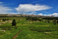
Cloud Peak Wilderness: Paintrock/Solitude Trail/Cloud Peak- June '15

Bryan Harwood

Member
Joined
Mar 24, 2016
Messages
26
11406497_1592373321050403_3007779244099295881_o.jpg

3 da, 32 mile loop. half trail- half- trek. June 2015
So... What to say about the Cloud Peak Wilderness... Its a small wilderness situated on the main crest of the Bighorn Mountains in north central Wyoming. Its a pure gem. Its intimate and "easily" traversed. By that I mean, its not so overwhelmingly massive that a major portion of the wilderness can be seen in only one trip. I took 5 trips into the Cloud Peak, and I have seen a damn good amount of it. This trip being my first, was the longest and hardest. I bit off alot, but I managed to chew it up and swallow it... without choking.. to death anyway.
The road to my access point, Paintrock Lake, is a godaweful rutted, muddy, washboarded, steep, gravelly, narrow, outsloped piece of 30 mile crap. But this is the most remote way of getting into the main Cloud Peak Summit area, and probably the least utilized for that purpose. The main attraction fro this spot is the Solitude Trail that traverses the entire Wilderness from East/West to South. However which way you wanna look at it.

10014372_1592373311050404_8862128701410042715_o.jpg

I worked on The Bighorn NF the summer of 2015, as the trail crew leader for the Porcupine Falls trail construction project, which I can post about later.., so the Cloud Peak was my backyard.

11041712_1592373447717057_3612288029298133478_n.jpg

A pretty creek scene as the Alpine approaches in sight

11148335_1592373294383739_9201322350122993571_o.jpg

This is Teepee Flats. Its a junction for the main trails. It is a gorgeous spot, but the bugs can get really bad.

10298882_1592373467717055_6604817028311900160_n.jpg

Very beautiful granite boulders, which are actually a mofo to trek over!

11538961_1592373667717035_3388239258762814535_o.jpg

An exceptionally remarkable meadow beneath the gentle slopes of the alpine high country

10507159_1592373684383700_2244044316632376079_o.jpg

and theres me :)

11423391_1592373771050358_3186038511417513180_o.jpg

This is Lake Solitude. This is a very pretty lake. There are alot of moose out here. I had one step on my tent during the night, and it scared the hell out of me so bad. This is looking East toward the inlet.

11112831_1592373627717039_1961555994457609753_o.jpg

Alpine sunset on Lake Solitude

11110473_1592373827717019_7722943146904546324_n.jpg

The Next day, I trekked up and over this drainage to meet up the the main approach to Cloud Peak. This is Lake Solitude from the drainage above to the East.

10339501_1592374294383639_3884259225035308270_o.jpg

Going Up :) I thought this looked like a Gate into a Gothic world of Dragons and orcs.

10507159_1592374601050275_5831085610943171830_o.jpg

Alpine Camera Timer is my hiking partner most of the time

11538119_1592374631050272_1876477481322769190_o.jpg

Alpine Pools of glorious Colors.

11357215_1592374721050263_7134934963989041396_o.jpg

Sweet Cliffs that look like Castle Walls

11270448_1592374767716925_1205640338442494213_o.jpg

B&W

10502250_1592374837716918_1469262353544022233_n.jpg

There is the Cloud Peak Summit and the talos field of death.

10450939_1592374911050244_3191086242874450179_n.jpg

A Closer look at the neat profile of the Cloud PEak

11204458_1592375117716890_8912500640889902132_n.jpg

Going UP!!! Man im gettin high.

11417747_1592375127716889_3366336935785885939_o.jpg

Sweet!!!!! Almost There.

11426371_1592374957716906_1612886132477795026_o.jpg

The Top. This is the View looking West into the drainage of unnamed lakes. The Top of Cloud Peak has a HUGE surface. To get a 360 degree view, you have to hop over thousands of rocks so I just decided to hang out here. The other views were good to though, just not as dramatic.

11143309_1592375164383552_9060997273934066009_o.jpg

Heading back down. A long ways back to camp... Im already burnt out..

10584106_1592375384383530_8077711980892328320_n.jpg

Alpine flowers

11143353_1592375361050199_8887974629481931030_o.jpg

Sweet day, but it is far from over... 6 more miles of traversing hard bouldered country :)

11535700_1592375387716863_8816027055537250985_n.jpg

Sweet Ponds everywhere

11215872_1592374784383590_6307928753092552491_n.jpg

I love these kind of shots!

IMG_3092.JPG
So The next day was a long haul back to the Trailhead.
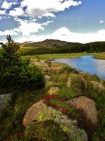
I finished off the loop on a trail that pretty much siezed to exist once I got deeper away from the high use areas...
IMG_3127.JPG
sweet areas though. I had to do some major navigation. I got a bit confused of my where- abouts, but luckily I am pretty savy on map reading.
IMG_3260.JPG
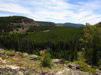
characteristic of the Bighorn Mountains

The Cloud Peak Wilderness is a sweet ass place. Just know that once above timberline and trekking in the alpine, the boulders are so agonizingly large that you should plan on maybe shortening your mileage plans between destination points, atleast when trekking trailless territory. other than that the trails are in good shape, in the high use areas.

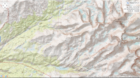
here is the map. its too big to fit it all so This is the main stuff
cloud peak.png
 
11406497_1592373321050403_3007779244099295881_o.jpg

3 da, 32 mile loop. half trail- half- trek. June 2015
So... What to say about the Cloud Peak Wilderness... Its a small wilderness situated on the main crest of the Bighorn Mountains in north central Wyoming. Its a pure gem. Its intimate and "easily" traversed. By that I mean, its not so overwhelmingly massive that a major portion of the wilderness can be seen in only one trip. I took 5 trips into the Cloud Peak, and I have seen a damn good amount of it. This trip being my first, was the longest and hardest. I bit off alot, but I managed to chew it up and swallow it... without choking.. to death anyway.
The road to my access point, Paintrock Lake, is a godaweful rutted, muddy, washboarded, steep, gravelly, narrow, outsloped piece of 30 mile crap. But this is the most remote way of getting into the main Cloud Peak Summit area, and probably the least utilized for that purpose. The main attraction fro this spot is the Solitude Trail that traverses the entire Wilderness from East/West to South. However which way you wanna look at it.

10014372_1592373311050404_8862128701410042715_o.jpg

I worked on The Bighorn NF the summer of 2015, as the trail crew leader for the Porcupine Falls trail construction project, which I can post about later.., so the Cloud Peak was my backyard.

11041712_1592373447717057_3612288029298133478_n.jpg

A pretty creek scene as the Alpine approaches in sight

11148335_1592373294383739_9201322350122993571_o.jpg

This is Teepee Flats. Its a junction for the main trails. It is a gorgeous spot, but the bugs can get really bad.

10298882_1592373467717055_6604817028311900160_n.jpg

Very beautiful granite boulders, which are actually a mofo to trek over!

11538961_1592373667717035_3388239258762814535_o.jpg

An exceptionally remarkable meadow beneath the gentle slopes of the alpine high country

10507159_1592373684383700_2244044316632376079_o.jpg

and theres me :)

11423391_1592373771050358_3186038511417513180_o.jpg

This is Lake Solitude. This is a very pretty lake. There are alot of moose out here. I had one step on my tent during the night, and it scared the hell out of me so bad. This is looking East toward the inlet.

11112831_1592373627717039_1961555994457609753_o.jpg

Alpine sunset on Lake Solitude

11110473_1592373827717019_7722943146904546324_n.jpg

The Next day, I trekked up and over this drainage to meet up the the main approach to Cloud Peak. This is Lake Solitude from the drainage above to the East.

10339501_1592374294383639_3884259225035308270_o.jpg

Going Up :) I thought this looked like a Gate into a Gothic world of Dragons and orcs.

10507159_1592374601050275_5831085610943171830_o.jpg

Alpine Camera Timer is my hiking partner most of the time

11538119_1592374631050272_1876477481322769190_o.jpg

Alpine Pools of glorious Colors.

11357215_1592374721050263_7134934963989041396_o.jpg

Sweet Cliffs that look like Castle Walls

11270448_1592374767716925_1205640338442494213_o.jpg

B&W

10502250_1592374837716918_1469262353544022233_n.jpg

There is the Cloud Peak Summit and the talos field of death.

10450939_1592374911050244_3191086242874450179_n.jpg

A Closer look at the neat profile of the Cloud PEak

11204458_1592375117716890_8912500640889902132_n.jpg

Going UP!!! Man im gettin high.

11417747_1592375127716889_3366336935785885939_o.jpg

Sweet!!!!! Almost There.

11426371_1592374957716906_1612886132477795026_o.jpg

The Top. This is the View looking West into the drainage of unnamed lakes. The Top of Cloud Peak has a HUGE surface. To get a 360 degree view, you have to hop over thousands of rocks so I just decided to hang out here. The other views were good to though, just not as dramatic.

11143309_1592375164383552_9060997273934066009_o.jpg

Heading back down. A long ways back to camp... Im already burnt out..

10584106_1592375384383530_8077711980892328320_n.jpg

Alpine flowers

11143353_1592375361050199_8887974629481931030_o.jpg

Sweet day, but it is far from over... 6 more miles of traversing hard bouldered country :)

11535700_1592375387716863_8816027055537250985_n.jpg

Sweet Ponds everywhere

11215872_1592374784383590_6307928753092552491_n.jpg

I love these kind of shots!

View attachment 41679
So The next day was a long haul back to the Trailhead.
I finished off the loop on a trail that pretty much siezed to exist once I got deeper away from the high use areas...

View attachment 41680
sweet areas though. I had to do some major navigation. I got a bit confused of my where- abouts, but luckily I am pretty savy on map reading.

View attachment 41681
characteristic of the Bighorn Mountains

The Cloud Peak Wilderness is a sweet ass place. Just know that once above timberline and trekking in the alpine, the boulders are so agonizingly large that you should plan on maybe shortening your mileage plans between destination points, atleast when trekking trailless territory. other than that the trails are in good shape, in the high use areas.

here is the map. its too big to fit it all so This is the main stuff
View attachment 41682
 
Hey Bryan,
I'm brand-new to this site so forgive me if I don't know how to use it yet. I literally signed up about 5 minutes ago. Love your pictures & notes from CPW. I'm thinking about heading out there for the first 2 weeks of July. Thinking about taking 9-10 days to hike the Solitude Loop. It would be just me and my dog. (80# Dutch Shepherd) She's a great trail dog and I'm in decent shape. (I can consistently cover 10-12 miles a day on the Appalachian Trail carrying a 45# load.) You have any tips or suggestions for me? (other than "What an idiot!...Don't do it!") Would love your hear your feedback & advice on this. Thanks.
Welcome! Please post a new thread http://backcountrypost.com/forums/noobs-introduce-yourself.119/ here to introduce yourself! I also recommend posting your questions in the Trip Planning section since several other members may know of the Bighorns.
 
Hey Bryan,
I'm brand-new to this site so forgive me if I don't know how to use it yet. I literally signed up about 5 minutes ago. Love your pictures & notes from CPW. I'm thinking about heading out there for the first 2 weeks of July. Thinking about taking 9-10 days to hike the Solitude Loop. It would be just me and my dog. (80# Dutch Shepherd) She's a great trail dog and I'm in decent shape. (I can consistently cover 10-12 miles a day on the Appalachian Trail carrying a 45# load.) You have any tips or suggestions for me? (other than "What an idiot!...Don't do it!") Would love your hear your feedback & advice on this. Thanks.
You might look at @Scott Chandler past trip reports. He was a Wilderness Ranger at Cloud Peak for the summers of 2014 and 2015. (I have to give him a shout out!) He is currently a ranger in Katmai NP Alaska so he is a bit out of reach.
 
Similar threads
Thread starter Title Forum Replies Date
RockyMntCol Cloud Peak Wilderness Loop Trip Planning 1
la_alpinista Thoughts on potential off trail routes in Cloud Peak Wilderness CPW Trip Planning 1
Curt Visiting (Part of) the Lake District of Cloud Peak Wilderness Backpacking 15
Curt Lost Twin Lakes, Cloud Peak Wilderness, Wyoming Backpacking 16
P Cloud Peak Wilderness--Edelman Trailhead Backpacking 0
Bryan Harwood Cloud Peak Wilderness: USFS Trail Clearing Hitch Sept.2015 Backpacking 2
Scott Chandler Darton Ridge-Cloud Peak Wilderness Hiking & Camping 6
T Cloud Peak backpack Trip Planning 0
Parma Idaho's White Cloud Mountains - Boulder Chain Lakes - Chamberlain Basin Backpacking 8
J White Cloud Route. 2018 June 22 Trip Planning 3
S White Cloud route, Big Boulder Lakes to Boulder Chain Lakes Trip Planning 3
balzaccom SEKI Explored...Cloud Canyon and Roaring River Backpacking 0
T Questions about next week in White Cloud Wilderness Trip Planning 2
blueeyes Adobe Creative Cloud Photography 7
BobFink Goschute Mountains, NV , Pisgah Peak, Hawk Watch Migration Site Everything Else 3
TheMountainRabbit Ortenburger Lake, Talus Lake, & Glacier Peak (Grand Teton NP) - October 2023 Backpacking 14
scatman Ensign Peak to Grandview Peak - October 9, 2023 Hiking & Camping 30
scatman Yellowstone's Thorofare, Headwaters of Thorofare Creek, Majo Pass, Younts Peak, Bob's Canyon, and Cub Creek - August 9, 2023 - Days 7 through 10 Backpacking 34
scatman Yellowstone's Thorofare, Headwaters of Thorofare Creek, Majo Pass, Younts Peak, Bob's Canyon, and Cub Creek - August 9, 2023 - Days 1 through 6 Backpacking 56
RockyMntCol Trip Planning Younts Peak / South Fork Yellowstone Trip Planning 12
scatman Reid's Peak - Uintas - July 22, 2023 Hiking & Camping 6
W Paper map for Teton Wilderness (Younts Peak) Gear 4
scatman Grandeur Peak - Dragon Tail Route - June 10, 2023 Hiking & Camping 13
scatman Lookout Peak - May 27, 2023 Hiking & Camping 13
scatman Frary Peak - Antelope Island - February 20, 2023 Hiking & Camping 10
scatman Ensign Peak - November 24, 2022 Hiking & Camping 11
scatman Grandeur Peak - November 11, 2022 Hiking & Camping 15
Titans What’s your unfinished business? Hard canyon access, mtn peak, you name it! General Discussion 54
ram Eldorado Peak 2022 Backpacking 3
TheMountainRabbit Younts Peak (Teton/Washakie Wilderness) - July 2022 Backpacking 22
regehr Lookout Peak 6/25/22 Hiking & Camping 3
scatman Unnamed Peak 8194 - June 25, 2022 Hiking & Camping 17
scatman Mendon Peak - Wellsville Mountain Wilderness - June 4, 2022 Hiking & Camping 13
scatman Dale Peak - May 22, 2022 Hiking & Camping 21
westy Invite Glacier Peak, Washington Meet Up (Members Only) 2
TheMountainRabbit Invite Younts Peak, July 2022 Meet Up (Members Only) 11
LarryBoy SLC: Terrace Hills Drive to Big Mountain Peak Trip Planning 16
ram Glacier Peak July 2021 Backpacking 9
scatman Grandeur Peak - January 15, 2022 Hiking & Camping 6
scatman Frary Peak - Antelope Island - January 7, 2022 Hiking & Camping 21
Wanderlust073 Raleigh Peak Hiking & Camping 4
scatman Grandeur Peak Loop - December 4, 2021 Hiking & Camping 4
scatman Dale Peak - November 27, 2021 Hiking & Camping 3
scatman Grandeur Peak - Dagon's Tail Route - November 21, 2021 Hiking & Camping 9
K Kings Peak Trip Trip Planning 6
TrektheWorld Crater Lake and Lone Eagle Peak Backpacking 1
scatman Lone Peak - July 14, 2021 Hiking & Camping 28
Bob Yellowstone - Electric Peak visit Backpacking 2
scatman Lewiston Peak - May 15, 2021 Hiking & Camping 7
LarryBoy Looping the Highline: Gilbert Peak Edition Backpacking 13

Similar threads

Back
Top