IntrepidXJ
ADVENTR
- Joined
- Jan 17, 2012
- Messages
- 3,480
Saturday & Sunday, April 21-22, 2012
The Original Trip report on ADVENTR.CO
I was originally supposed to go camping this weekend with Amanda, but at the last minute she was unable to go with me, so I had to figure out something else to do. I sent an email to Marty to see if he was free on the weekend for some hiking on Cedar Mesa, but I figured he already had plans and I would be on my own. To my surprise, he was free and willing to join me. At first he thought he would only be joining me on Saturday, but he ended up camping overnight and exploring with me the whole weekend.
We met up in Blanding at the usual gas station so that we could top off our fuel tanks before driving through Comb Ridge and up onto Cedar Mesa. We made a quick stop at the Kane Gulch Ranger Station so that I could finally grab my Annual Hiking Permit for the year, and then continued on to the Owl Creek Canyon trailhead. I was surprised to see so many vehicles parked here. I guess I am used to hiking the lesser travelled canyons in Cedar Mesa, because I wasn’t expecting the parking area to be packed. Normally I would probably turn around and find somewhere else to go, but I sucked it up and continued on down into Owl Canyon for a short hike.
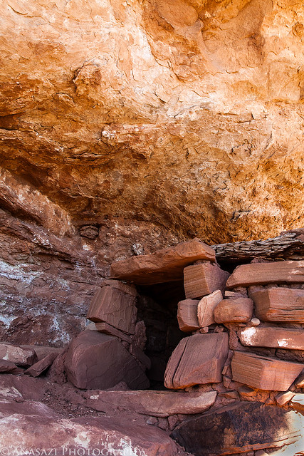
We stopped and visited the well-preserved set of ruins just in the large alcove along the trail. There were some very interesting and unique ruins here.
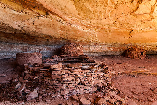
Owl Creek Alcove by IntrepidXJ, on Flickr
There were also some pictographs painted on the ceiling of the alcove.
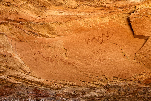
Paintings by IntrepidXJ, on Flickr
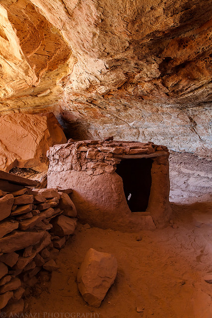
Small Room by IntrepidXJ, on Flickr
A closer look at some handprints.
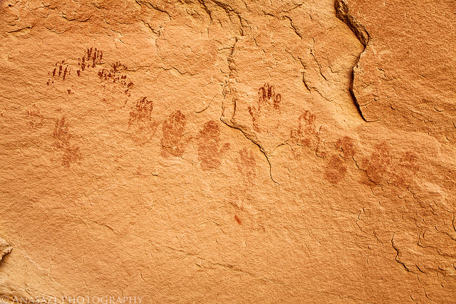
Ceiling Hands by IntrepidXJ, on Flickr
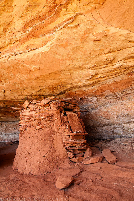
This ruin was interesting, as one side was constructed using parts of a Juniper Tree, while the rest was stone.

Juniper Tree Granary by IntrepidXJ, on Flickr
Here's a view of the other side.
Owl Creek Granary by IntrepidXJ, on Flickr
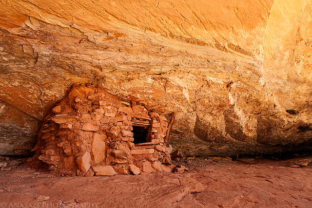
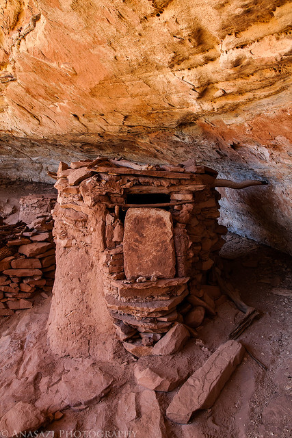
This structure was oddly shaped compared to most that I come across, and it had an interesting doorway, too.
Strange Door by IntrepidXJ, on Flickr
A closer look at the doorway from the front.
Front Door by IntrepidXJ, on Flickr
After visiting the ruins we continued hiking down the canyon for a bit and explored a short side canyon looking for more ruins before turning around and hiking back out.
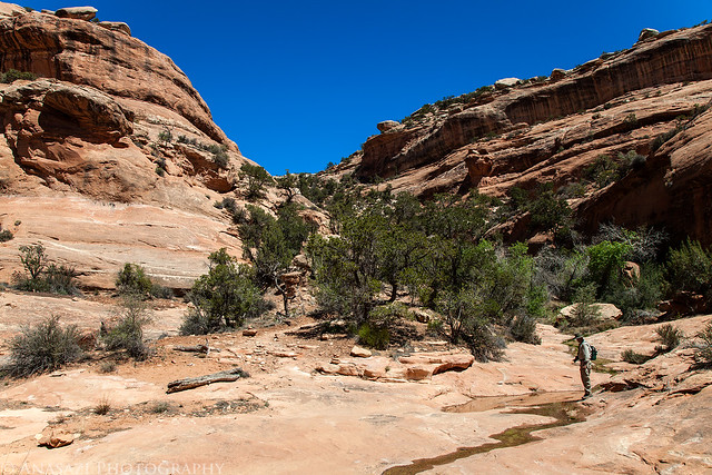
Marty in the Canyon by IntrepidXJ, on Flickr
Next up, we went back to check out The Birthing Panel rock art site that I almost missed two weeks earlier. We arrived a little late for the light I was hoping for, but I still managed to get some nice shots of these amazing petroglyphs.
When we first arrived, this lizard was just hanging out on the large boulder near the petroglyphs.
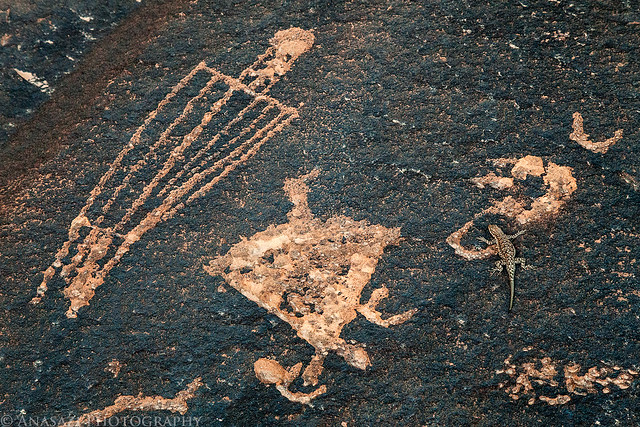
Lizard & Petroglyphs by IntrepidXJ, on Flickr
This small panel is found in the corner. There appears to be a duck-headed figure and a very tall and skinny flute player.
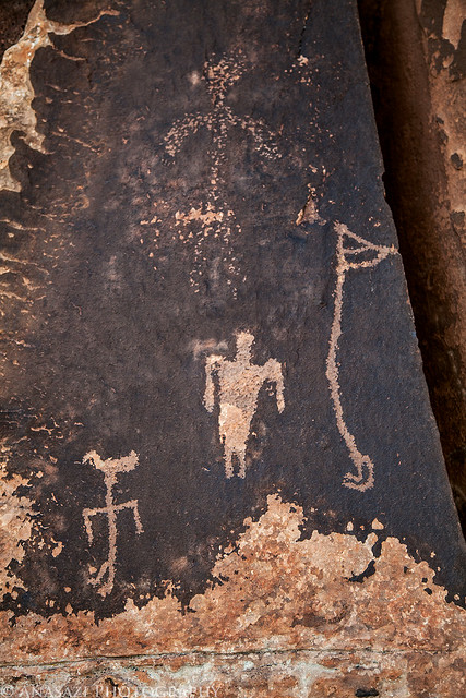
Corner Duck Head by IntrepidXJ, on Flickr
From conception to birth... This known as The Birthing Panel. I don't think it really requires and further explanation.
The Birthing Panel by IntrepidXJ, on Flickr
Marty took this photo of me taking the previous photo.
Photographing The Birthing Panel by Marty, on Flickr
This large flat boulder with dark desert varnish contains a number of interesting petroglyphs, including a bunch of tracks.
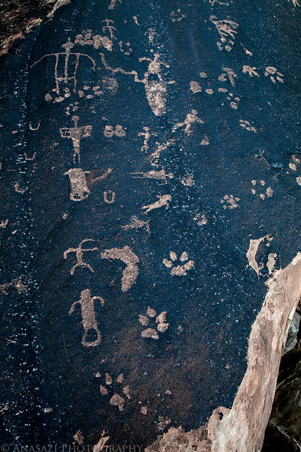
Many Tracks by IntrepidXJ, on Flickr
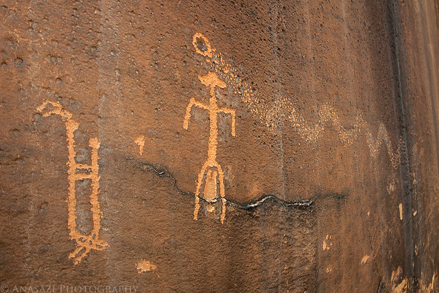
There's also a few of these striped anthropomorphs found here.
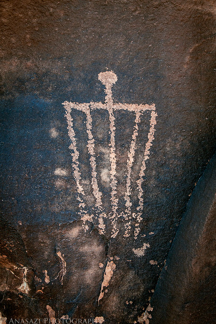
Stripe Man by IntrepidXJ, on Flickr
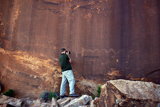
Here's an overall view of the previous petroglyphs so you can get a sense of how they appear in their setting and surroundings. It's a pretty cool area.
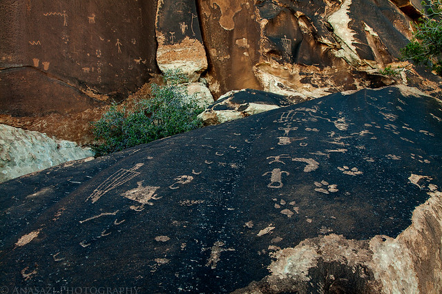
Petroglyph Corner by IntrepidXJ, on Flickr
We also went to see a small ruin that I had visited a few years back when I only had a point & shoot camera. We explored a little more of the canyon and found another small but well-preserved granary.
I visited the Collapsed Roof Ruin a few years back with Jared and wanted to return for a better photo. A large slab of rock has fallen from the roof of the alcove and is currently supported by the ruins below. Unfortunately, it appears I needed to be there earlier in the day as the light wasn't the greatest. I guess I will have to return again.
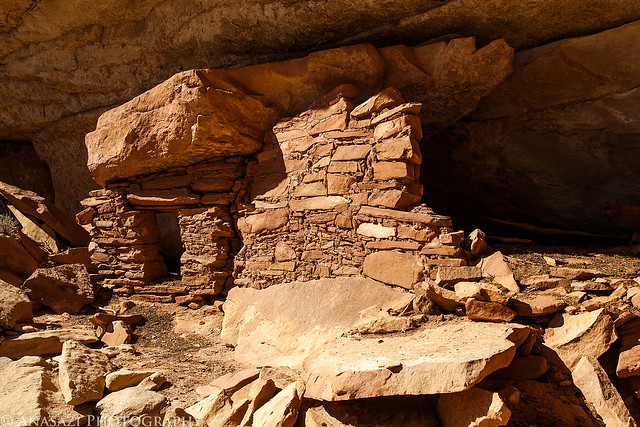
Collapsed Roof Ruin by IntrepidXJ, on Flickr
There was also a very nice round granary nearby, but again, it was half in the shade and half in direct light...so I just took a photo of the doorway.
Round Granary Door by IntrepidXJ, on Flickr
I must have missed these handprints since I don't remember them from my previous visit to the site.
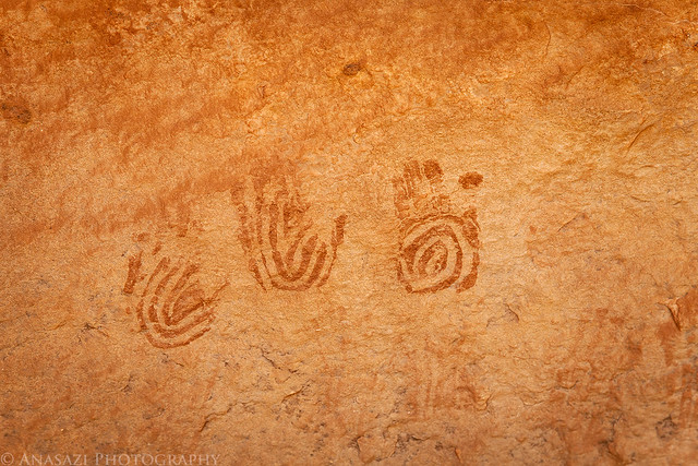
Three Hands by IntrepidXJ, on Flickr
There was actually a whole wall filled with faint handprints here.
Wall of Faded Hands by IntrepidXJ, on Flickr
Finally, we headed over to Muley Point to catch the sunset. We weather was actually very nice up there, so we decided to setup camp. Normally it’s pretty windy up there, but on this evening it was very calm...and it’s stayed that way all night. I couldn’t have asked for better camping weather that night.
Exploring Muley Point.
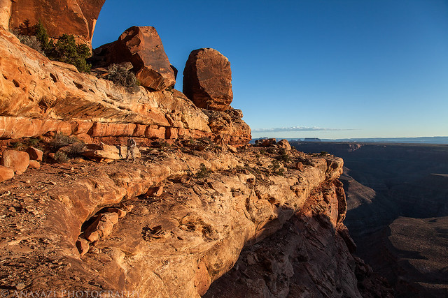
Walking the Ledge by IntrepidXJ, on Flickr
Marty took this photo of me as I climbed out of a narrow slot up onto the top of Muley Point again.

Climbing Out of the Slot by Marty, on Flickr
Great views up here at sunset.
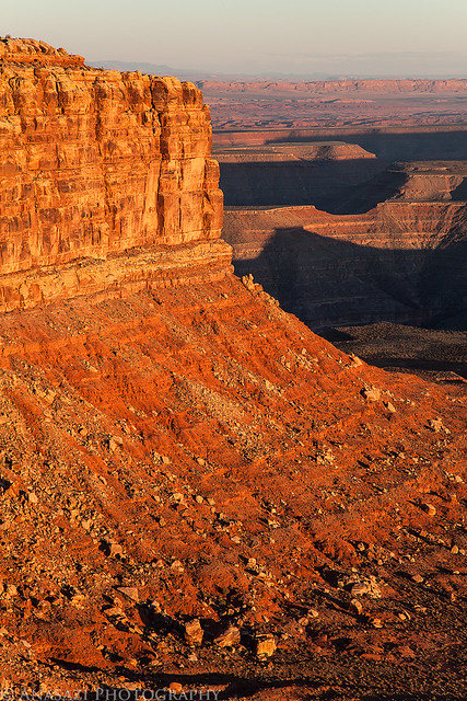
Muley Point Sunset by IntrepidXJ, on Flickr
As we hiked back to our camp, I noticed our shadows cast on the distant sandstone wall framed between some large fallen boulders.
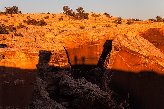
Shadows on the Wall by IntrepidXJ, on Flickr
The next morning we were up just in time to catch the sunrise. It was nice watching the sunlight strike the sandstone monoliths in Monument Valley in the distance followed by the rims of the canyons below along the San Juan River. Of course we took photos...
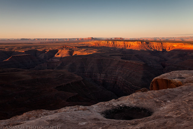
Cloudless Muley Point Sunrise by IntrepidXJ, on Flickr
My home for the night.
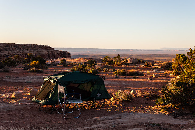
Morning Camp by IntrepidXJ, on Flickr
After breakfast and packing up camp we took the switchbacks of the Moki Dugway down off of Cedar Mesa and followed the dirt road that leads to Johns Canyon. We stopped along the way to look for some petroglyphs at the base of Cedar Point, but after spending some time searching we came up empty-handed. We continued along Johns Canyon Road so that I could revisit a few petroglyph sites that I hadn’t been back to in a few years...including the awesome Duckhead Man Panel.
Duckhead Man by IntrepidXJ, on Flickr
Right Side by IntrepidXJ, on Flickr
Duckhead & Friends by IntrepidXJ, on Flickr

Marty and the Duckhead by IntrepidXJ, on Flickr
Dotted Man Panel by IntrepidXJ, on Flickr
I have plans to head back to Johns Canyon for a full weekend of exploring so we turned around after the Duckhead Man Panel and drove to Bluff. Before continuing back home we stopped near Bluff to find a few more petroglyph panels.
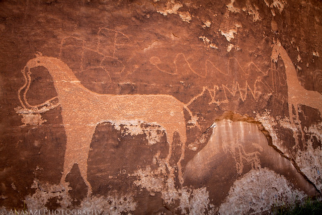
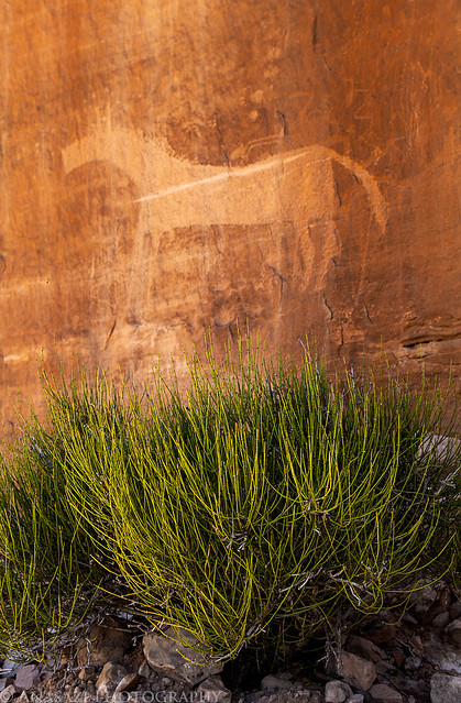
The first panels we visited included a number of large horses. Obviously, this panel is more recent than most of the petroglyphs I visit, but the large horses are still pretty cool. If you look closely, you can see that these horses were carved over some much older petroglyphs.
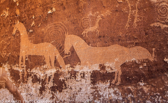
Horses & Spirals by IntrepidXJ, on Flickr
Horses & Petroglyphs by IntrepidXJ, on Flickr
A Horse by IntrepidXJ, on Flickr
After visiting the horse petroglyphs, I visited this very unique and detailed Navajo Yei figure hidden behind a large fallen boulder. This was a tough one to photograph. Besides the low light, this figure was carved in a light colored sandstone, so there was really no contrast to set it apart from the surround stone. I think I did a pretty good job bringing it out in the photo below. If you click on the photo, you can view a larger size where the details are more visible.
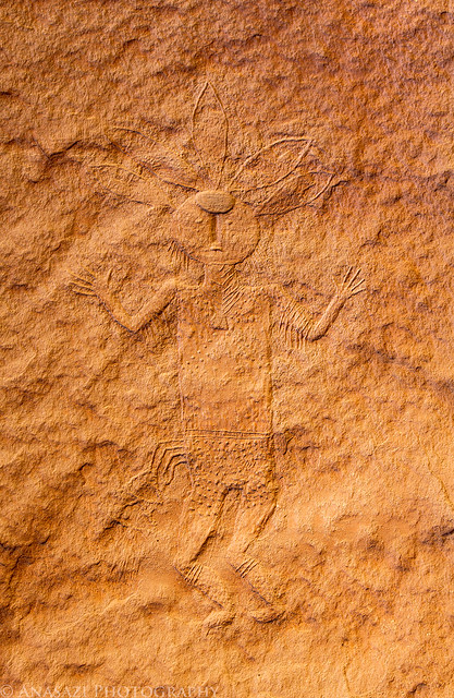
Navajo Yei by IntrepidXJ, on Flickr
After hiking back to the Jeep we made our way to Monticello and grabbed some dinner at Taco Time before finishing the drive back home. What else can I say? It was another excellent weekend exploring Cedar Mesa!
>> Cedar Mesa & Bluff Photo Gallery
Featured image for slideshow:

The Original Trip report on ADVENTR.CO
I was originally supposed to go camping this weekend with Amanda, but at the last minute she was unable to go with me, so I had to figure out something else to do. I sent an email to Marty to see if he was free on the weekend for some hiking on Cedar Mesa, but I figured he already had plans and I would be on my own. To my surprise, he was free and willing to join me. At first he thought he would only be joining me on Saturday, but he ended up camping overnight and exploring with me the whole weekend.
We met up in Blanding at the usual gas station so that we could top off our fuel tanks before driving through Comb Ridge and up onto Cedar Mesa. We made a quick stop at the Kane Gulch Ranger Station so that I could finally grab my Annual Hiking Permit for the year, and then continued on to the Owl Creek Canyon trailhead. I was surprised to see so many vehicles parked here. I guess I am used to hiking the lesser travelled canyons in Cedar Mesa, because I wasn’t expecting the parking area to be packed. Normally I would probably turn around and find somewhere else to go, but I sucked it up and continued on down into Owl Canyon for a short hike.
We stopped and visited the well-preserved set of ruins just in the large alcove along the trail. There were some very interesting and unique ruins here.
Owl Creek Alcove by IntrepidXJ, on Flickr
There were also some pictographs painted on the ceiling of the alcove.
Paintings by IntrepidXJ, on Flickr
Small Room by IntrepidXJ, on Flickr
A closer look at some handprints.
Ceiling Hands by IntrepidXJ, on Flickr
This ruin was interesting, as one side was constructed using parts of a Juniper Tree, while the rest was stone.
Juniper Tree Granary by IntrepidXJ, on Flickr
Here's a view of the other side.
Owl Creek Granary by IntrepidXJ, on Flickr
This structure was oddly shaped compared to most that I come across, and it had an interesting doorway, too.
Strange Door by IntrepidXJ, on Flickr
A closer look at the doorway from the front.
Front Door by IntrepidXJ, on Flickr
After visiting the ruins we continued hiking down the canyon for a bit and explored a short side canyon looking for more ruins before turning around and hiking back out.
Marty in the Canyon by IntrepidXJ, on Flickr
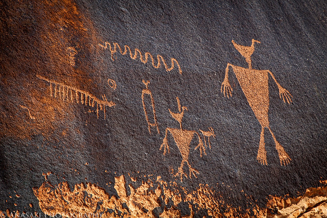
Next up, we went back to check out The Birthing Panel rock art site that I almost missed two weeks earlier. We arrived a little late for the light I was hoping for, but I still managed to get some nice shots of these amazing petroglyphs.
When we first arrived, this lizard was just hanging out on the large boulder near the petroglyphs.
Lizard & Petroglyphs by IntrepidXJ, on Flickr
This small panel is found in the corner. There appears to be a duck-headed figure and a very tall and skinny flute player.
Corner Duck Head by IntrepidXJ, on Flickr
From conception to birth... This known as The Birthing Panel. I don't think it really requires and further explanation.
The Birthing Panel by IntrepidXJ, on Flickr
Marty took this photo of me taking the previous photo.
Photographing The Birthing Panel by Marty, on Flickr
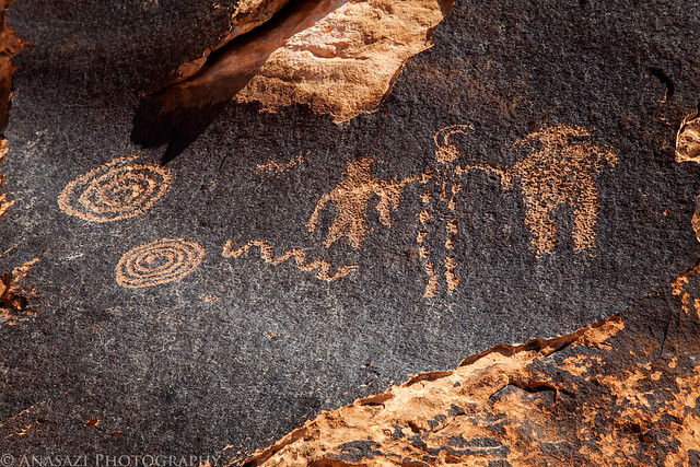
This large flat boulder with dark desert varnish contains a number of interesting petroglyphs, including a bunch of tracks.
Many Tracks by IntrepidXJ, on Flickr
There's also a few of these striped anthropomorphs found here.
Stripe Man by IntrepidXJ, on Flickr
Here's an overall view of the previous petroglyphs so you can get a sense of how they appear in their setting and surroundings. It's a pretty cool area.
Petroglyph Corner by IntrepidXJ, on Flickr
We also went to see a small ruin that I had visited a few years back when I only had a point & shoot camera. We explored a little more of the canyon and found another small but well-preserved granary.
I visited the Collapsed Roof Ruin a few years back with Jared and wanted to return for a better photo. A large slab of rock has fallen from the roof of the alcove and is currently supported by the ruins below. Unfortunately, it appears I needed to be there earlier in the day as the light wasn't the greatest. I guess I will have to return again.
Collapsed Roof Ruin by IntrepidXJ, on Flickr
There was also a very nice round granary nearby, but again, it was half in the shade and half in direct light...so I just took a photo of the doorway.
Round Granary Door by IntrepidXJ, on Flickr
I must have missed these handprints since I don't remember them from my previous visit to the site.
Three Hands by IntrepidXJ, on Flickr
There was actually a whole wall filled with faint handprints here.
Wall of Faded Hands by IntrepidXJ, on Flickr
Finally, we headed over to Muley Point to catch the sunset. We weather was actually very nice up there, so we decided to setup camp. Normally it’s pretty windy up there, but on this evening it was very calm...and it’s stayed that way all night. I couldn’t have asked for better camping weather that night.
Exploring Muley Point.
Walking the Ledge by IntrepidXJ, on Flickr
Marty took this photo of me as I climbed out of a narrow slot up onto the top of Muley Point again.
Climbing Out of the Slot by Marty, on Flickr
Great views up here at sunset.
Muley Point Sunset by IntrepidXJ, on Flickr
As we hiked back to our camp, I noticed our shadows cast on the distant sandstone wall framed between some large fallen boulders.
Shadows on the Wall by IntrepidXJ, on Flickr
The next morning we were up just in time to catch the sunrise. It was nice watching the sunlight strike the sandstone monoliths in Monument Valley in the distance followed by the rims of the canyons below along the San Juan River. Of course we took photos...
Cloudless Muley Point Sunrise by IntrepidXJ, on Flickr
My home for the night.
Morning Camp by IntrepidXJ, on Flickr
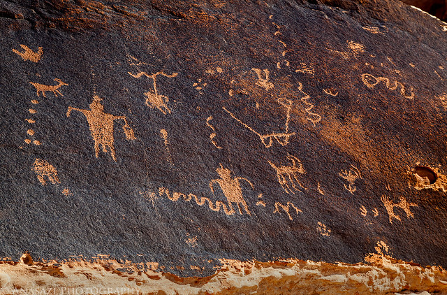
After breakfast and packing up camp we took the switchbacks of the Moki Dugway down off of Cedar Mesa and followed the dirt road that leads to Johns Canyon. We stopped along the way to look for some petroglyphs at the base of Cedar Point, but after spending some time searching we came up empty-handed. We continued along Johns Canyon Road so that I could revisit a few petroglyph sites that I hadn’t been back to in a few years...including the awesome Duckhead Man Panel.
Duckhead Man by IntrepidXJ, on Flickr
Right Side by IntrepidXJ, on Flickr
Duckhead & Friends by IntrepidXJ, on Flickr
Marty and the Duckhead by IntrepidXJ, on Flickr
Dotted Man Panel by IntrepidXJ, on Flickr
I have plans to head back to Johns Canyon for a full weekend of exploring so we turned around after the Duckhead Man Panel and drove to Bluff. Before continuing back home we stopped near Bluff to find a few more petroglyph panels.
The first panels we visited included a number of large horses. Obviously, this panel is more recent than most of the petroglyphs I visit, but the large horses are still pretty cool. If you look closely, you can see that these horses were carved over some much older petroglyphs.
Horses & Spirals by IntrepidXJ, on Flickr
Horses & Petroglyphs by IntrepidXJ, on Flickr
A Horse by IntrepidXJ, on Flickr
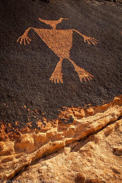
After visiting the horse petroglyphs, I visited this very unique and detailed Navajo Yei figure hidden behind a large fallen boulder. This was a tough one to photograph. Besides the low light, this figure was carved in a light colored sandstone, so there was really no contrast to set it apart from the surround stone. I think I did a pretty good job bringing it out in the photo below. If you click on the photo, you can view a larger size where the details are more visible.
Navajo Yei by IntrepidXJ, on Flickr
After hiking back to the Jeep we made our way to Monticello and grabbed some dinner at Taco Time before finishing the drive back home. What else can I say? It was another excellent weekend exploring Cedar Mesa!
>> Cedar Mesa & Bluff Photo Gallery
Featured image for slideshow: