It would be a lot of fun to take a walk out there and see. I was just in Fiftymile last weekend. I think I might have made a point to hike up there if I'd known about it before hand.
Yup you were an integral part of that crimesolving unit, I should have given credit where it was due. Hopefully @Aldaron is packing his bags and looking for airfare so the band can get back together. You need @ashergrey to join you too since he has done some nice backcountry detective work himself. I'm already imagining a trip report from you guys that somehow involves a broken plane, a briefcase of cash, heroin residue, and suspicion of an FBI coverup.
Seriously though, as Nick pointed out.. It couldn't have landed there on that terrain but looks to be virtually on the ground with the lack of shadow. Isn't it plausible then that the image was taken the moment before impact and you'd find wreckage?
If you research the N-number, it appears Congress appropriated to give the plane to the Kane County Sheriff's Office so the National Park Service could use it to patrol Glen Canyon NRA. It's based out of Page. You can even see it sitting outside a hangar on the ramp in satellite imagery dated 5/29/2013.
My guess is the pilot was flying low over terrain in that satellite shot, making it look like he was grounded. Sun must have been pretty much directly overhead.
Here's my 2 cents. Since most of the satellites that provide Google Earth imagery are over 400 miles up (2 million and some feet), anything remotely close to the ground will appear to be "pinned" to the ground. Even if this plane was 2 or 5 thousand feet up, it would likely appear really close to the ground. If you look at the existing shadows, the sun appears to be close to vertical but not quite, so how far up would the plane be to have it's shadow out of the picture? I don't know either but I bet it's more than 1 or 2 thousand feet. Additionally, the handful of plane crash remnants I have witnessed do not involve an intact plane, even on the relatively soft tundra.
The size of the plane would appear much larger to the camera the further away from the ground (and closer to the camera) that it is. The closer to the ground it is, the more true the scale. I don't believe this could be thousands of feet up without appearing ridiculously large (unless it's actually a toy plane!). The measurements taken in GE indicate that it's close to actual size.
Why are there no other planes in satellite imagery when there are thousands flying around at any given time? I believe it is because they are effectively focused into nothing, kind of like shooting through a bug splattered windshield with a long lens. You focus out far enough and they basically disappear. All of those planes flying way up high are not within the plane of focus - we just don't see the tiny spots.
But it's also a matter of perspective. Imagine you are able to see a banking plane from 400 miles away (50 miles east of Denver if you are in SLC). Another similar plane is also banking but is 1000, 2000 or 5000 feet closer to you. Do you think you will really notice a big difference in size? I doubt I would.
I'd bet he was flying less than 500 feet off the ground, perhaps way lower. It doesn't matter what I think, it's a scientific fact that things look larger or smaller depending on how close they are. Does a river in the bottom of a canyon look significantly larger or smaller if you're standing on a 1,000 foot cliff or a 5,000 foot cliff? Even if it's taken from 200 miles up, that difference in scale still exists.
I was scoping out the area near Westwater looking for a campsite and I found all these weird round features all over the place. Does anyone know what they are? They almost look like the frack pads up near Duchesne and in SW Wyoming, except 1000 years from now when they're just ruins.
Oh, and anyone want to share a good campsite between Crescent Junction and Fruita? I can repay the favor.
Rabbit Valley....check out the Castle Rock and Knowles Overlook campsites. I've never seen anyone else at either of them. Take the Rabbit Valley exit and follow the McDonald Creek Road back towards Utah a few miles.
Don't know what causes them but you can see some from street view. Some have dried mud inside... they collect (or maybe seep?) water which explains the surrounding plants.
Looks like geological or hydrological test pits. As seen from the air they tend to fall on or next to dry gullies. Maybe someone looking for placer deposits?
I was scoping out the area near Westwater looking for a campsite and I found all these weird round features all over the place. Does anyone know what they are? They almost look like the frack pads up near Duchesne and in SW Wyoming, except 1000 years from now when they're just ruins.
I checked them out in 2008 with Listorama from Flickr--I didn't take any photos there, but here are a couple of his (including one with me caught in a goofy pose).
According to people at the BLM, these are contour pits, man-made structures "designed to control sedimentation and salinity contributions to the Colorado River. They were constructed by BLM by the thousands in the Cisco Desert in the 1980s…" Officials eventually determined that the structures did not appreciably reduce sedimentation and salinity. Thanks to Ann Marie Aubry of the BLM for solving this mystery and to Byron Loosle of the BLM for steering me to the person with the answer.
")


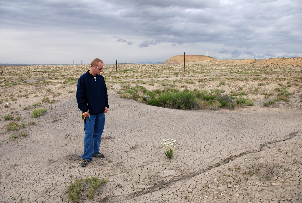 20080512_9913...Udink and the mysterious formations
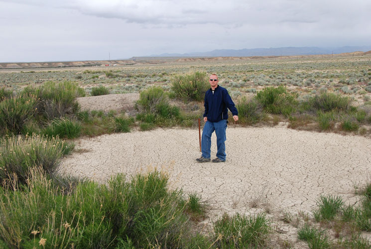 20080512_9925...Dennis inside a berm