- Joined
- Aug 9, 2007
- Messages
- 12,949
Just two days after getting home from my trip to Zion and subsequent few days working in the St. George area, I was on my way to Idaho to do a solo backpacking trip in the Sawtooth Wilderness. This trip would involve some firsts for me. It would be my first time in The Sawtooths and the first time going truly solo, meaning no dog, in an alpine environment. Exciting!
Here are my GPS tracks from my route. I totalled just shy of 24 miles with my side explorations. A simple round trip to the north shore of Imogene and back to the Hell Roaring trailhead would be about 18 miles.
[parsehtml]
<iframe src="http://www.mappingsupport.com/p/gmap4.php?q=mymap,214533597045798101523.0004c3c844aadeb56bf19&z=13&t=t4" frameborder="0" marginwidth="0" marginheight="0" scrolling="no" width="850" height="700"></iframe><br>
<small>View <a href="http://www.mappingsupport.com/p/gmap4.php?q=mymap,214533597045798101523.0004c3c844aadeb56bf19&z=13&t=t4" target="_blank">Imogene and Hell Roaring Lake Map</a> full sized in a new window.</small><br><br>
[/parsehtml]I got kind of a late start out of Salt Lake, not hitting the road until around 8am. By the time I made it to the Hell Roaring 'trailhead', it was nearly 3pm! Good thing it's a quick and easy 5 miles to Hell Roaring Lake from here. Based on the popularity of this hike and pictures of the huge trailhead signboard I'd seen before, I was surprised that the lower trailhead was so primitive. There was no good parking, just some spots off the side of the road, no facilities and no information aside from this mileage marker.

The first mile of the trail climbs up the toe of a large moraine, gaining much of the total elevation gain along the trail. This is one of the few spots along the route that Hell Roaring Creek does much roaring.

After just less than a mile, the slope flattens out and the river flows gently. From here on out, the river goes in and out of sight and the trail is easy walking with almost no rocks in the trail or anything. You can really sail from here up to Hell Roaring if you were so inclined.

This is so funny to me. About a quarter mile past the wilderness boundary and 3 miles up the trail, I arrived at the official trailhead. I thought maybe they put it here because some people might come in via the 4WD upper trailhead but that trail actually meets the main trail well up canyon from here!
Along with some goofy regulations, I had to pickup a free wilderness permit here. Day hikers have to do the same.

One of the stranger regulations that I had no idea existed before now. You can have a fire here but only if you pack in a fire blanket or fire pan. No using the countless, well-constructed fire rings in the area. I'd like to see more mention of this, and if not on the web, etc. but perhaps at the actual trailhead?? I didn't really intend to have a fire anyway but I imagine some folks plan on cooking over the fire and wouldn't know there was a silly rule like this until they were already 3 miles deep and 60% of the way to Hell Roaring Lake. Go forest service...

A couple more miles and a bit more elevation gained and I was at the outlet of Hell Roaring Lake


I walked all the way around the lake on the south shore, passing by a few campsites but hoping for something better. I ended up off trail all the way up on the west end of the lake and decided to hike all the way back to the outlet so I'd have some better views of the big rocky peaks in the morning light. They were all back-lit when I arrived so they didn't look great in photos.
After dropping my gear, I went down to Hell Roaring Creek and took some photos.

I tried out my new Tenkara fly rod here and briefly got a tiny little fish on but then nothing. It was a pretty tough river to fish and the lake was even worse. I don't think there are many fish in any of these lakes and what are there seem to be tiny.

I went to bed shortly after dark and slept like a baby all night. I was not far from Hell Roaring Creek so the white noise factor was prime. I think I got like 11 hours of great vivid dreaming in before I finally crawled out of my tent.
I immediately walked out to the shore line to see a glassy surface on Hell Roaring Lake and good light on the peaks above.

My campsite at Hell Roaring Lake

I had a leisurely morning and eventually packed up and started up to Imogene Lake. It was 10:30 by the time I hit the trail but I only had 4 miles to get to Imogene so I was in no hurry. The trail gains a bit more than 1,000 feet but is well constructed and never gets very steep at all. It was easy, fast hiking except for the occasional snow drift in the trail like this.

The trail passes by several small lakes and ponds along the way to Imogene.

I loved this bridge over this big waterfall. The water was actually flowing over the deck in spots. I'm kind of surprised this holds up over year after year of high runoff.


Shortly after that bridge I ran into the first really big snow obstacle. The trail completely disappeared here so I just went straight up, finding a nice line slightly to the left where I was able to largely stay out of the snow. I thought the trail had gone to the right but it turns out it had actually taken a hard left here.

Another couple hundred yards from the snow and I crossed over a small ridge and voila! Imogene Lake! Notice the ice build up on the shore. I learned shortly that the previous day this lake was 70% covered in ice.

I met some a friendly group of campers along the north shore, Ken and his sons Christian and Andrew. They had been up there for a couple days and told me about how it was mostly iced over up until today. We talked for a while and discussed hiking out together in the morning through the big snowfield. Then Ken gave me some pointers on where to find good campsites along the west shore and I was off to find my next home for the night.
The north shore had some awesome little bays edged by big slabs of granite.

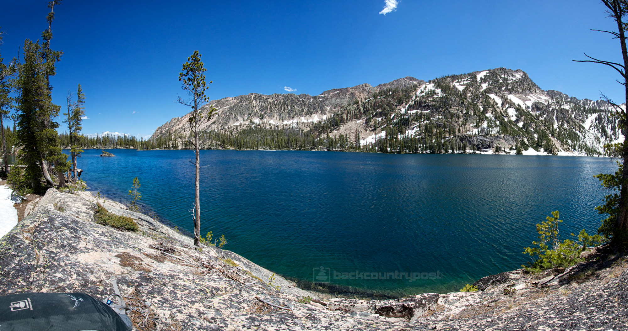
I walked the shore for a while before finding this nice spot about half way up to the island. This was my sitting rock. I spent a few hours that afternoon laying here reading before heading out on a day hike towards the inlet of Imogene. Click on the pano below for a larger view from my perch along the shore of Imogene.
Before I set out on my day hike, I setup my tent and unloaded some unnecessary gear. Here's a shot of my camp.

View of my backpack on my awesome sitting rock from camp.

Later in the afternoon, I threw on my pack and headed up along the shore of the lake toward the island and the inlet. At the very minimum, I wanted to check out what almost appeared to be an ice bridge over to the island. It was definitely nothing crossable, but still cool. When I first arrived at the lake, it was piled high out of the water but had shrinked down to water level by the time I got over there in the afternoon.

This is skipping ahead a bit, but when I hiked back by this point a little more than 2 hours later, all but that one big patch of ice was completely melted. This pic is taken at almost the same place as the one above but 2 hrs 20 minutes later.

Another shot of the ice at 4:30pm

And the same spot at 6:50pm

I was kind of hoping to find some way to cross over to the island but the water was way too high. You could see an underwater path of stepping stones that would get you there if the water was a couple feet lower but I did not want to get that wet so I continued along the shore, picking my way around snow drifts until I finally reached the inlet. The inlet was a broad flooded area that was almost like an extension of the lake. Just wide channels flowing in and around patches of trees. I finally reached a point where the trail would cross a narrow section on some precarious logs but the other side was snow as far as I could see.

I had a nice view of water pouring down slabs above Imogene at this point but couldn't find a safe way to get to it.

I poked around a cliff band west of the waterfall for a bit and finally found a way up with just a tiny bit of scrambling that got me up onto the next level and above that big waterfall.

Looking across the river above the lower waterfall. Everything on the other side of the river was pretty much buried in snow still.

I decided to keep picking my way up through the waterfalls as far as the snow and terrain would allow. There were some awesome cascades running here and there but the light was difficult.

One section of the river flowing under a snow bridge.

And soon I arrived at Mushroom Lake, the next lake up from Imogene and to my delight, it was mostly covered in ice!

Here's a few shots of the ice and snow at Mushroom Lake


There was another small lake just up from Mushroom and then another a hundred+ feet above that (elevation). I made my way to the next small lake before finally hitting enough snow that I decided to turn around. I was solo and didn't want to put myself in too much risk.

The small upper lake just above Mushroom and a small cascade connecting them. You can kind of see the next ledge that holds the next lake up in this cirque labeled 8700' on the USGS topo.

Being on the east side of the range, it was tough shooting towards the massive peaks to the west this time of day.

Picking my way back along Mushroom Lake, the light was a little better this way.

Finally back at the lower cliff band. This is where I scrambled up and around that first waterfall.

Back at Imogene Lake. This is where the inlet finally breaks free into the lake.

I got back to camp a little after 7pm. The mosquitoes were now out in force so I threw on some layers and a bit of deet and laid out on my rock and ate dinner and read more. I've been backpacking with a Kindle lately and I'm absolutely loving it, especially solo.
I had brought a long a new piece of equipment to try out on this trip. It's the UCO Micro Candle Lantern. It weighs 4.2 ounces with two candles inside and collapses smaller so the glass is not exposed. Seems like it might be a good thing to use this year since campfires are banned pretty much everywhere.

A couple of things I noticed. Those tiny holes around the base leak wax like crazy if you disturb the lantern at all while the tea light is full. I burned one tea light which lasted upwards of 3 hours before I finally just blew it out. It was definitely close to being done though. It also caught a few mosquitoes. I didn't keep it going after dark since I just went to bed, but that's where it really shines. I've sat around one of these in camp chairs with a group of people and it actually gives a decent camp fire vibe. Just enough light to see people's faces and hang out.

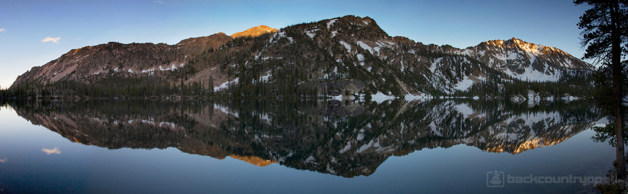
It was windy all day but just as the last bit of light was fading, the wind stopped and the lake glassed over for some nice reflections.


And here's a large pano from my sitting rock on the shore near my camp. Click on it to see it in a larger size.
The next morning I woke up and had some breakfast out by the shore, hiding in the shade of some big trees.

The light at this angle really showed off the beautiful color of Imogene Lake.

Around 9am I made my way back over to meet up with Ken and sons before heading down the snow field back towards Hell Roaring Lake. A nice lake along the trail down.

I hiked with them for a mile or so, passing through all of the drifts before heading off on my own. I booked it fast from there. I still had to drive all the way to Boise and check into a hotel. I stopped to snap a few shots as I passed by Hell Roaring Lake. This formation is called The Finger of Fate. A popular rock climbing destination. I saw a few climbers heading up that way the previous morning.

Looking up from Hell Roaring. That drainage on the left is the one above Imogene that I hiked up the previous day.

I put away my trekking poles and walked swiftly for the remainder of the hike, making it from Hell Roaring Lake to the trailhead 5 miles below in just under 1.5 hours.

Overall this was a fantastic trip. I loved being solo and not having a dog. It sounds kind of crazy because I always thought the dog offered an additional layer of protection but what ended up happening is Nikita would always be on alert and so I would always be looking over my shoulder, wondering what she was focusing in on. Without that going on, I was able to just fully relax and enjoy myself. I carried bear spray and hung my food but I feel the spray was unnecessary. I never saw any sign of bear at all although black bears do exist in the Sawtooths. I do believe I saw some wolf prints but that's not much of a concern.
As far as how the Sawtooths stack up against other mountain ranges, they are very nice, but I don't know that I'll make a point to go there often. They have beautiful jagged granite peaks which are great, something the Uintas generally lack. But the low elevation means more dense forest and little to no high tundra type terrain. Also, it doesn't appear that the Idaho Fish and Game actively manage the fish population here. Two lakes like Imogene and Hell Roaring in the Uintas would be teeming with fish but here in The Sawtooths they were basically non-existent. I saw a few rise right at the end of the day but otherwise no sign and I sat by the deep shoreline at Imogene looking into those clear waters for hours. And last, the regulations seemed a bit heavy and from what I'm told, it gets pretty crazy there in the July/August time frame.
Sounds kind of like I'm bagging on the Sawtooths, doesn't it? I'm not, they were cool, but ultimately, if I were going to drive 4+ hours from SLC to backpack, I'd pick something like The Wind Rivers, The Beartooths, Yellowstone, Glacier etc. next time around. But if I lived a bit closer to the Teeth... I'd be all over this place.
I had a hell of a time narrowing down photos for this report. There are plenty more in the set on Flickr if you want to see them all.
Featured image for home page:

Here are my GPS tracks from my route. I totalled just shy of 24 miles with my side explorations. A simple round trip to the north shore of Imogene and back to the Hell Roaring trailhead would be about 18 miles.
[parsehtml]
<iframe src="http://www.mappingsupport.com/p/gmap4.php?q=mymap,214533597045798101523.0004c3c844aadeb56bf19&z=13&t=t4" frameborder="0" marginwidth="0" marginheight="0" scrolling="no" width="850" height="700"></iframe><br>
<small>View <a href="http://www.mappingsupport.com/p/gmap4.php?q=mymap,214533597045798101523.0004c3c844aadeb56bf19&z=13&t=t4" target="_blank">Imogene and Hell Roaring Lake Map</a> full sized in a new window.</small><br><br>
[/parsehtml]I got kind of a late start out of Salt Lake, not hitting the road until around 8am. By the time I made it to the Hell Roaring 'trailhead', it was nearly 3pm! Good thing it's a quick and easy 5 miles to Hell Roaring Lake from here. Based on the popularity of this hike and pictures of the huge trailhead signboard I'd seen before, I was surprised that the lower trailhead was so primitive. There was no good parking, just some spots off the side of the road, no facilities and no information aside from this mileage marker.
The first mile of the trail climbs up the toe of a large moraine, gaining much of the total elevation gain along the trail. This is one of the few spots along the route that Hell Roaring Creek does much roaring.
After just less than a mile, the slope flattens out and the river flows gently. From here on out, the river goes in and out of sight and the trail is easy walking with almost no rocks in the trail or anything. You can really sail from here up to Hell Roaring if you were so inclined.
This is so funny to me. About a quarter mile past the wilderness boundary and 3 miles up the trail, I arrived at the official trailhead. I thought maybe they put it here because some people might come in via the 4WD upper trailhead but that trail actually meets the main trail well up canyon from here!
Along with some goofy regulations, I had to pickup a free wilderness permit here. Day hikers have to do the same.
One of the stranger regulations that I had no idea existed before now. You can have a fire here but only if you pack in a fire blanket or fire pan. No using the countless, well-constructed fire rings in the area. I'd like to see more mention of this, and if not on the web, etc. but perhaps at the actual trailhead?? I didn't really intend to have a fire anyway but I imagine some folks plan on cooking over the fire and wouldn't know there was a silly rule like this until they were already 3 miles deep and 60% of the way to Hell Roaring Lake. Go forest service...
A couple more miles and a bit more elevation gained and I was at the outlet of Hell Roaring Lake
I walked all the way around the lake on the south shore, passing by a few campsites but hoping for something better. I ended up off trail all the way up on the west end of the lake and decided to hike all the way back to the outlet so I'd have some better views of the big rocky peaks in the morning light. They were all back-lit when I arrived so they didn't look great in photos.
After dropping my gear, I went down to Hell Roaring Creek and took some photos.
I tried out my new Tenkara fly rod here and briefly got a tiny little fish on but then nothing. It was a pretty tough river to fish and the lake was even worse. I don't think there are many fish in any of these lakes and what are there seem to be tiny.
I went to bed shortly after dark and slept like a baby all night. I was not far from Hell Roaring Creek so the white noise factor was prime. I think I got like 11 hours of great vivid dreaming in before I finally crawled out of my tent.
I immediately walked out to the shore line to see a glassy surface on Hell Roaring Lake and good light on the peaks above.
My campsite at Hell Roaring Lake
I had a leisurely morning and eventually packed up and started up to Imogene Lake. It was 10:30 by the time I hit the trail but I only had 4 miles to get to Imogene so I was in no hurry. The trail gains a bit more than 1,000 feet but is well constructed and never gets very steep at all. It was easy, fast hiking except for the occasional snow drift in the trail like this.
The trail passes by several small lakes and ponds along the way to Imogene.
I loved this bridge over this big waterfall. The water was actually flowing over the deck in spots. I'm kind of surprised this holds up over year after year of high runoff.
Shortly after that bridge I ran into the first really big snow obstacle. The trail completely disappeared here so I just went straight up, finding a nice line slightly to the left where I was able to largely stay out of the snow. I thought the trail had gone to the right but it turns out it had actually taken a hard left here.
Another couple hundred yards from the snow and I crossed over a small ridge and voila! Imogene Lake! Notice the ice build up on the shore. I learned shortly that the previous day this lake was 70% covered in ice.
I met some a friendly group of campers along the north shore, Ken and his sons Christian and Andrew. They had been up there for a couple days and told me about how it was mostly iced over up until today. We talked for a while and discussed hiking out together in the morning through the big snowfield. Then Ken gave me some pointers on where to find good campsites along the west shore and I was off to find my next home for the night.
The north shore had some awesome little bays edged by big slabs of granite.
I walked the shore for a while before finding this nice spot about half way up to the island. This was my sitting rock. I spent a few hours that afternoon laying here reading before heading out on a day hike towards the inlet of Imogene. Click on the pano below for a larger view from my perch along the shore of Imogene.
Before I set out on my day hike, I setup my tent and unloaded some unnecessary gear. Here's a shot of my camp.
View of my backpack on my awesome sitting rock from camp.
Later in the afternoon, I threw on my pack and headed up along the shore of the lake toward the island and the inlet. At the very minimum, I wanted to check out what almost appeared to be an ice bridge over to the island. It was definitely nothing crossable, but still cool. When I first arrived at the lake, it was piled high out of the water but had shrinked down to water level by the time I got over there in the afternoon.
This is skipping ahead a bit, but when I hiked back by this point a little more than 2 hours later, all but that one big patch of ice was completely melted. This pic is taken at almost the same place as the one above but 2 hrs 20 minutes later.
Another shot of the ice at 4:30pm
And the same spot at 6:50pm
I was kind of hoping to find some way to cross over to the island but the water was way too high. You could see an underwater path of stepping stones that would get you there if the water was a couple feet lower but I did not want to get that wet so I continued along the shore, picking my way around snow drifts until I finally reached the inlet. The inlet was a broad flooded area that was almost like an extension of the lake. Just wide channels flowing in and around patches of trees. I finally reached a point where the trail would cross a narrow section on some precarious logs but the other side was snow as far as I could see.
I had a nice view of water pouring down slabs above Imogene at this point but couldn't find a safe way to get to it.
I poked around a cliff band west of the waterfall for a bit and finally found a way up with just a tiny bit of scrambling that got me up onto the next level and above that big waterfall.
Looking across the river above the lower waterfall. Everything on the other side of the river was pretty much buried in snow still.
I decided to keep picking my way up through the waterfalls as far as the snow and terrain would allow. There were some awesome cascades running here and there but the light was difficult.
One section of the river flowing under a snow bridge.
And soon I arrived at Mushroom Lake, the next lake up from Imogene and to my delight, it was mostly covered in ice!
Here's a few shots of the ice and snow at Mushroom Lake
There was another small lake just up from Mushroom and then another a hundred+ feet above that (elevation). I made my way to the next small lake before finally hitting enough snow that I decided to turn around. I was solo and didn't want to put myself in too much risk.
The small upper lake just above Mushroom and a small cascade connecting them. You can kind of see the next ledge that holds the next lake up in this cirque labeled 8700' on the USGS topo.
Being on the east side of the range, it was tough shooting towards the massive peaks to the west this time of day.
Picking my way back along Mushroom Lake, the light was a little better this way.
Finally back at the lower cliff band. This is where I scrambled up and around that first waterfall.
Back at Imogene Lake. This is where the inlet finally breaks free into the lake.
I got back to camp a little after 7pm. The mosquitoes were now out in force so I threw on some layers and a bit of deet and laid out on my rock and ate dinner and read more. I've been backpacking with a Kindle lately and I'm absolutely loving it, especially solo.
I had brought a long a new piece of equipment to try out on this trip. It's the UCO Micro Candle Lantern. It weighs 4.2 ounces with two candles inside and collapses smaller so the glass is not exposed. Seems like it might be a good thing to use this year since campfires are banned pretty much everywhere.
A couple of things I noticed. Those tiny holes around the base leak wax like crazy if you disturb the lantern at all while the tea light is full. I burned one tea light which lasted upwards of 3 hours before I finally just blew it out. It was definitely close to being done though. It also caught a few mosquitoes. I didn't keep it going after dark since I just went to bed, but that's where it really shines. I've sat around one of these in camp chairs with a group of people and it actually gives a decent camp fire vibe. Just enough light to see people's faces and hang out.
It was windy all day but just as the last bit of light was fading, the wind stopped and the lake glassed over for some nice reflections.
And here's a large pano from my sitting rock on the shore near my camp. Click on it to see it in a larger size.
The next morning I woke up and had some breakfast out by the shore, hiding in the shade of some big trees.
The light at this angle really showed off the beautiful color of Imogene Lake.
Around 9am I made my way back over to meet up with Ken and sons before heading down the snow field back towards Hell Roaring Lake. A nice lake along the trail down.
I hiked with them for a mile or so, passing through all of the drifts before heading off on my own. I booked it fast from there. I still had to drive all the way to Boise and check into a hotel. I stopped to snap a few shots as I passed by Hell Roaring Lake. This formation is called The Finger of Fate. A popular rock climbing destination. I saw a few climbers heading up that way the previous morning.
Looking up from Hell Roaring. That drainage on the left is the one above Imogene that I hiked up the previous day.
I put away my trekking poles and walked swiftly for the remainder of the hike, making it from Hell Roaring Lake to the trailhead 5 miles below in just under 1.5 hours.
Overall this was a fantastic trip. I loved being solo and not having a dog. It sounds kind of crazy because I always thought the dog offered an additional layer of protection but what ended up happening is Nikita would always be on alert and so I would always be looking over my shoulder, wondering what she was focusing in on. Without that going on, I was able to just fully relax and enjoy myself. I carried bear spray and hung my food but I feel the spray was unnecessary. I never saw any sign of bear at all although black bears do exist in the Sawtooths. I do believe I saw some wolf prints but that's not much of a concern.
As far as how the Sawtooths stack up against other mountain ranges, they are very nice, but I don't know that I'll make a point to go there often. They have beautiful jagged granite peaks which are great, something the Uintas generally lack. But the low elevation means more dense forest and little to no high tundra type terrain. Also, it doesn't appear that the Idaho Fish and Game actively manage the fish population here. Two lakes like Imogene and Hell Roaring in the Uintas would be teeming with fish but here in The Sawtooths they were basically non-existent. I saw a few rise right at the end of the day but otherwise no sign and I sat by the deep shoreline at Imogene looking into those clear waters for hours. And last, the regulations seemed a bit heavy and from what I'm told, it gets pretty crazy there in the July/August time frame.
Sounds kind of like I'm bagging on the Sawtooths, doesn't it? I'm not, they were cool, but ultimately, if I were going to drive 4+ hours from SLC to backpack, I'd pick something like The Wind Rivers, The Beartooths, Yellowstone, Glacier etc. next time around. But if I lived a bit closer to the Teeth... I'd be all over this place.
I had a hell of a time narrowing down photos for this report. There are plenty more in the set on Flickr if you want to see them all.
Featured image for home page:
")