- Joined
- May 5, 2012
- Messages
- 1,725
Work on the Kim and Carole project occupied most of my time in the Uintas last summer, but I was able to slip in one quick overnighter at Hell Hole Lake.

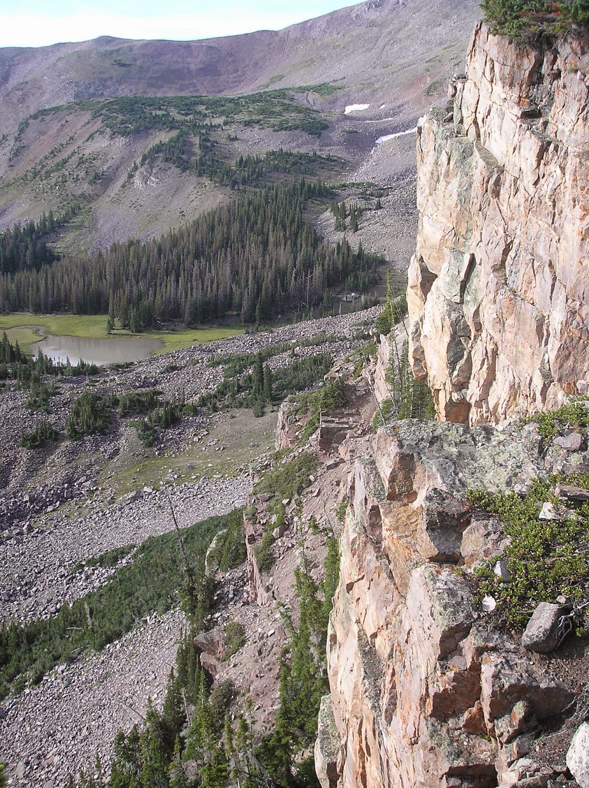
Hell Hole sits in a nice little valley nestled between A-1 Peak on the east and Kletting Peak on the west. It's accessed either via the Mirror Lake Highway or a gated road that spurs off the Stillwater road and plows right through the forest to a drill pad site. Either way, part of the approach hike involves a tedious and thoroughly un-beautiful walk on this road.
The official trailhead for Hell Hole Lake sits a laughable 2.5 miles from where hikers start on the Mirror Lake Highway approach.

According to this archived Deseret News article, Chevron agreed to build the trailhead and adjacent parking area as part of the controversial drilling project.
They did that... but also placed a gate on the road at the Stillwater bridge, 3.5 miles up the road. These kinds of games on public lands, in my mind, exhibit why people oppose any oil and gas exploration/drilling on the north slope of the Uintas. It often comes with the promise of improved/increased access, but the reality is more restriction.

Anyway, off the soapbox and onto the trail.
Wildfire haze and a prevalent high pressure system combined to make photography conditions less than ideal.

Several people were fly-fishing the shoreline of Hell Hole when I arrived at the outlet. I worked around the eastern shore looking for a campsite. There's a nice one at the south end of the lake in a grove of trees, so long as you don't mind the rotting sheep remains.

Since I wasn't sleeping on the ground, this site sufficed.

[PARSEHTML]<iframe src="http://www.mappingsupport.com/p/gmap4.php?q=https://dl.dropboxusercontent.com/u/3847512/GPS/Hell_Hole_ascent.kml&t=t4" frameborder="0" marginheight="0" scrolling="no" width="800" height="800"></iframe><br><br>[/PARSEHTML]After pitching camp, I walked around the lake to check out the west shore. All of the great sites there were covered with human excrement and toilet paper. Gross.

Sun started to get low.

With little cloud cover, the sunset skies didn't do much for me.


I wandered up the basin a little farther in search of a compelling composition.


The light retreated up A-1 and vanished, so I headed back to camp and stoked a fire before heading to bed.

Morning dawned early with a fresh coat of frost.

The area south of Hell Hole begged for exploration. Large open meadows full of deep grass hid the snaking paths of streams. Walking across the dew-covered expanses, I found large areas where deer or elk had obviously bedded down in recent days.


Following the water south and west led to a small pond right at the base of rocky slopes.

From here, a convenient ramp headed south up toward a bench below the Uinta ridgeline.

On the bench, I briefly toyed with the idea of making a run at A-1. That slope looked awful steep though, and I was alone. Probably not best to try it.

At one point, pushing through the brush, I accidentally flushed a big buck deer from its hiding place. It was maybe 15-20 feet away when it bounded away from me. Startled, a few choice words escaped my lips. My heart rate was already up from the elevation and exertion. Fight-or-flight pushed it even higher.
The views over the Hell Hole region were great, though they'd have been better with clearer air.

Perhaps the most interesting point of the hike came when, up on that saddle, my toe kicked something unexpected. It wasn't rock. It wasn't wood.
It was metal. Thick, heavy and half buried. I picked up and turned it over in my hand.

The item was six or eight inches long, about an inch wide and a quarter-inch thick. The flat edge had obviously been tooled, leaving it with diagonal grooves. The surface, which looked like a file, was pitted and degraded by rust. One edge had been pounded flat.

How, I wondered, did such a thing end up at the very top of a mountain basin at 11,200 feet above sea level? It's not the kind of thing a hiker or peak-bagger would carry. My best guess is it's some sort of tool from the tie hacking era of the late 1800s and early 1900s.
Even then though, there wouldn't have been much need for a tie hack to visit that bench. It's above tree line. Mysterious.
I dropped the object where I'd found it and headed for home.
[PARSEHTML]<iframe src="http://www.mappingsupport.com/p/gmap4.php?q=https://dl.dropboxusercontent.com/u/3847512/GPS/Hell_Hole_bench.kml&t=t4" frameborder="0" marginheight="0" scrolling="no" width="800" height="800"></iframe><br><br>[/PARSEHTML]
Hell Hole sits in a nice little valley nestled between A-1 Peak on the east and Kletting Peak on the west. It's accessed either via the Mirror Lake Highway or a gated road that spurs off the Stillwater road and plows right through the forest to a drill pad site. Either way, part of the approach hike involves a tedious and thoroughly un-beautiful walk on this road.
The official trailhead for Hell Hole Lake sits a laughable 2.5 miles from where hikers start on the Mirror Lake Highway approach.
According to this archived Deseret News article, Chevron agreed to build the trailhead and adjacent parking area as part of the controversial drilling project.
They did that... but also placed a gate on the road at the Stillwater bridge, 3.5 miles up the road. These kinds of games on public lands, in my mind, exhibit why people oppose any oil and gas exploration/drilling on the north slope of the Uintas. It often comes with the promise of improved/increased access, but the reality is more restriction.
Anyway, off the soapbox and onto the trail.
Wildfire haze and a prevalent high pressure system combined to make photography conditions less than ideal.
Several people were fly-fishing the shoreline of Hell Hole when I arrived at the outlet. I worked around the eastern shore looking for a campsite. There's a nice one at the south end of the lake in a grove of trees, so long as you don't mind the rotting sheep remains.
Since I wasn't sleeping on the ground, this site sufficed.
[PARSEHTML]<iframe src="http://www.mappingsupport.com/p/gmap4.php?q=https://dl.dropboxusercontent.com/u/3847512/GPS/Hell_Hole_ascent.kml&t=t4" frameborder="0" marginheight="0" scrolling="no" width="800" height="800"></iframe><br><br>[/PARSEHTML]After pitching camp, I walked around the lake to check out the west shore. All of the great sites there were covered with human excrement and toilet paper. Gross.
Sun started to get low.
With little cloud cover, the sunset skies didn't do much for me.
I wandered up the basin a little farther in search of a compelling composition.
The light retreated up A-1 and vanished, so I headed back to camp and stoked a fire before heading to bed.
Morning dawned early with a fresh coat of frost.
The area south of Hell Hole begged for exploration. Large open meadows full of deep grass hid the snaking paths of streams. Walking across the dew-covered expanses, I found large areas where deer or elk had obviously bedded down in recent days.
Following the water south and west led to a small pond right at the base of rocky slopes.
From here, a convenient ramp headed south up toward a bench below the Uinta ridgeline.
On the bench, I briefly toyed with the idea of making a run at A-1. That slope looked awful steep though, and I was alone. Probably not best to try it.
At one point, pushing through the brush, I accidentally flushed a big buck deer from its hiding place. It was maybe 15-20 feet away when it bounded away from me. Startled, a few choice words escaped my lips. My heart rate was already up from the elevation and exertion. Fight-or-flight pushed it even higher.
The views over the Hell Hole region were great, though they'd have been better with clearer air.
Perhaps the most interesting point of the hike came when, up on that saddle, my toe kicked something unexpected. It wasn't rock. It wasn't wood.
It was metal. Thick, heavy and half buried. I picked up and turned it over in my hand.
The item was six or eight inches long, about an inch wide and a quarter-inch thick. The flat edge had obviously been tooled, leaving it with diagonal grooves. The surface, which looked like a file, was pitted and degraded by rust. One edge had been pounded flat.
How, I wondered, did such a thing end up at the very top of a mountain basin at 11,200 feet above sea level? It's not the kind of thing a hiker or peak-bagger would carry. My best guess is it's some sort of tool from the tie hacking era of the late 1800s and early 1900s.
Even then though, there wouldn't have been much need for a tie hack to visit that bench. It's above tree line. Mysterious.
I dropped the object where I'd found it and headed for home.
[PARSEHTML]<iframe src="http://www.mappingsupport.com/p/gmap4.php?q=https://dl.dropboxusercontent.com/u/3847512/GPS/Hell_Hole_bench.kml&t=t4" frameborder="0" marginheight="0" scrolling="no" width="800" height="800"></iframe><br><br>[/PARSEHTML]