Ben
Member
- Joined
- Sep 12, 2014
- Messages
- 1,873
This was a very short over night out and back that i did near Kenai Fjords National Park. I don't recall exactly what i was thinking when i did this. I left late in the evening, hiked until it was dark in July in Alaska, got up in the morning and walked back.
On Caines Head there are remains of an old WWII fort, McGilvray, built to defend the port of Seward against Japanese incursion. I did not see any of this, i didn't devote enough time, just hiked out to North Beach and slept. I think i had to rush back to Anchorage to pick up some brake pads when the motorcycle shop opened after the week end. Or some thing. Also, the route follows the coast line at some points, and i was at the mercy of the tides as to what my options were for when i could leave.
The route starts from Lowell Point, just South of Seward, and travels above the shore through the forest, partly on a private road, until it comes down at Tonsina Creek and Tonsina Point. Looking across Resurrection Bay from that point.

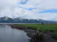
Tidal flats at Tonsina Point, Resurrection Peninsula across the same bay.

A picture of a picture of a picture.

Looking back to Seward in the "evening". Probably about 11 pm.

Most people's method of travel to the beach.

Pilings that remain from Fort McGilvray days. This is the next morning, cloudier.


Looking back up the coast from Derby Cove on the return trip.

Derby Cove. Possible to camp here also.


This is one of the spots that can be trouble if the tide is not low enough. There are two of these spots, and it is wise not to get stuck between them during high tide.

Looking back at Derby Cove, and the rise of Caines Head.

One of the cabins that it is possible to rent.

Rocks.

This is the second spot to be passed at lower tide. A tide table is available at the visitor center in Seward.

Flat Rocks.


These trees were killed by an earth quake. The quake caused the shore to subside, and salt from subsequent high tides killed them.


Back at the flats of Tonsina Point.

The bridge over Tonsina Creek.

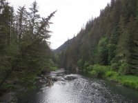
Tonsina Creek.

On Caines Head there are remains of an old WWII fort, McGilvray, built to defend the port of Seward against Japanese incursion. I did not see any of this, i didn't devote enough time, just hiked out to North Beach and slept. I think i had to rush back to Anchorage to pick up some brake pads when the motorcycle shop opened after the week end. Or some thing. Also, the route follows the coast line at some points, and i was at the mercy of the tides as to what my options were for when i could leave.
The route starts from Lowell Point, just South of Seward, and travels above the shore through the forest, partly on a private road, until it comes down at Tonsina Creek and Tonsina Point. Looking across Resurrection Bay from that point.
Tidal flats at Tonsina Point, Resurrection Peninsula across the same bay.
A picture of a picture of a picture.
Looking back to Seward in the "evening". Probably about 11 pm.
Most people's method of travel to the beach.
Pilings that remain from Fort McGilvray days. This is the next morning, cloudier.
Looking back up the coast from Derby Cove on the return trip.
Derby Cove. Possible to camp here also.
This is one of the spots that can be trouble if the tide is not low enough. There are two of these spots, and it is wise not to get stuck between them during high tide.
Looking back at Derby Cove, and the rise of Caines Head.
One of the cabins that it is possible to rent.
Rocks.
This is the second spot to be passed at lower tide. A tide table is available at the visitor center in Seward.
Flat Rocks.
These trees were killed by an earth quake. The quake caused the shore to subside, and salt from subsequent high tides killed them.
Back at the flats of Tonsina Point.
The bridge over Tonsina Creek.
Tonsina Creek.
") I don't miss that part of AK.
I don't miss that part of AK.