Laura
freespirittraveler
- Joined
- Oct 1, 2012
- Messages
- 961
I've been coming to Bishop for hiking and camping for over 20 years, but believe it or not (aside from a workshop with David Muench in 2012) I've never come here for photography. Stan and I stayed here over New Year's and I got some nice shots on just a few outings, so when I saw a storm was supposed to hit the Eastern Sierra I diverted my usual winter trip to Utah/Grand Canyon to Bishop.
The plan was to explore some of the jeep trails since I now have an AWD car, and there are plenty around here. When I got here the clouds were building, and I pulled off the side of the road to capture some of the color:

The storm was forecast to come in the next day. That morning I drove down Buttermilk Road, not sure where the best view would be. I saw a steep trail up one of the many hills (that I believe are cinder cones) that cover the area. And I mean STEEP, like 20 degrees steep. The light looked to be good, and I started to get panicky, feeling the pressure to NOT SCREW UP THE LIGHT. On my last photo trips I've brought an issue of Outdoor Photographer with an amazing article by David Leland Hyde about getting in touch with the landscape. It's totally inspirational. And I forgot to bring it. I was not in touch with the landscape or my surroundings, and as the mountain peaks lit up I was jumping from place to place trying to find a great view. And not paying attention-I kicked over my camera bag and the 16-35 mm f4 lens I rented went over the edge of a rock and hit the ground. $h!+. I kept shooting cause there was nothing I could do at that point. Got one decent shot:

The lens could still take pics, but the focus no longer worked and zoom stuck. Fortunately I bought the damage insurance, but geez, what a way to start the trip. And I love that lens. I decided to spend the day scouting for comps, and getting in touch with the landscape. The storm was moving in fast but it was a warm storm so snow was only forecast for 8500 feet at above. Below in the foothills were dust storms and severe winds, 50-70 mph. I've never experienced anything like that, it rocked my car like a tornado. I'd be driving along and suddenly dust would start racing down the road toward me:

Then would envelope the car:

I got the heck out of there and went down to the Owens Valley, which is only 15 miles from this. The difference was amazing-lenticular clouds were building in the sky. I sat right in the valley and tried to capture what it felt to be there. Too bad I didn't have a 16-35mm lens!

The Owens Valley is the deepest valley in the U.S., between two mountain ranges which can be seen in this photo. What happened in the Owens Valley, something I put on the same scale as the damming of Glen Canyon, is outlined in this excellent article:
http://www.sacbee.com/news/investigations/the-public-eye/article2588151.html
Signs that the area is owned by the City of Los Angeles are everywhere. Someone explain what loophole allows Los Angeles to use public funds to buy land and then declare it private:

I can't believe these signs haven't been shot up. Wish I'd had a pellet gun. Or a real one…..
Back to photography-I happily trespassed on this land (it's open for day use) and watched the storm build:

During the night a huge fire broke out, fanned by the fierce winds. I was scared as to what I'd find when I got up the next morning but aside from the smell of smoke there was rain everywhere. The fire was put out that day. It rained all day and I didn't get much shooting, but there was a nice sunrise:

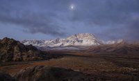
The next day the storm was forecast to move out, and I hit the Buttermilks with excitement. I'd scouted out some hills that promised good views, and yes, I was in touch with the landscape. Another steep climb, and I let the photos find me instead of the other way around. First there was an incredible view of the valley under moonlight:

I explored the hills, taking it all in as I waited for dawn. On my right, low clouds filled the valley, and because the light does not hit directly the colors were soft:

I was waiting for the light to hit certain peaks directly, which produces that amazing light beam across the mountains. Just as the light began to change, dark clouds moved in front of the peaks. At first I thought the shot I came for was ruined, but I took a few shots anyway. I'm so glad I did. After a day, this become my favorite shot. I'm getting tired of looking at photos (usually in a particular landscape magazine that shall remain nameless) that are so over saturated and overdone that they look like they've had plastic surgery. Beauty isn't perfect, and doesn't need to be:

This was the day that kept on giving. Every time I started to leave, I saw something else. The area is sometimes referred to as the American Alps, and here's why:


The geology of the place is amazing. The Sierras were formed by a combination of volcanic activity and plate movement that formed granite and pushed it upward. Old lava flows and cinder cones are everywhere, and the landscape changes from dry desert to rolling hills and cinder cones, and finally the massive Sierra Nevada:


Late afternoon by Farmer's Pond, brought to you by the L.A. Dept. of Water and Power, who wants to remind you that you are lucky to be allowed here:

I didn't have time to explore the petroglyphs, but there are everywhere. Maybe next trip!
The plan was to explore some of the jeep trails since I now have an AWD car, and there are plenty around here. When I got here the clouds were building, and I pulled off the side of the road to capture some of the color:
The storm was forecast to come in the next day. That morning I drove down Buttermilk Road, not sure where the best view would be. I saw a steep trail up one of the many hills (that I believe are cinder cones) that cover the area. And I mean STEEP, like 20 degrees steep. The light looked to be good, and I started to get panicky, feeling the pressure to NOT SCREW UP THE LIGHT. On my last photo trips I've brought an issue of Outdoor Photographer with an amazing article by David Leland Hyde about getting in touch with the landscape. It's totally inspirational. And I forgot to bring it. I was not in touch with the landscape or my surroundings, and as the mountain peaks lit up I was jumping from place to place trying to find a great view. And not paying attention-I kicked over my camera bag and the 16-35 mm f4 lens I rented went over the edge of a rock and hit the ground. $h!+. I kept shooting cause there was nothing I could do at that point. Got one decent shot:
The lens could still take pics, but the focus no longer worked and zoom stuck. Fortunately I bought the damage insurance, but geez, what a way to start the trip. And I love that lens. I decided to spend the day scouting for comps, and getting in touch with the landscape. The storm was moving in fast but it was a warm storm so snow was only forecast for 8500 feet at above. Below in the foothills were dust storms and severe winds, 50-70 mph. I've never experienced anything like that, it rocked my car like a tornado. I'd be driving along and suddenly dust would start racing down the road toward me:
Then would envelope the car:
I got the heck out of there and went down to the Owens Valley, which is only 15 miles from this. The difference was amazing-lenticular clouds were building in the sky. I sat right in the valley and tried to capture what it felt to be there. Too bad I didn't have a 16-35mm lens!
The Owens Valley is the deepest valley in the U.S., between two mountain ranges which can be seen in this photo. What happened in the Owens Valley, something I put on the same scale as the damming of Glen Canyon, is outlined in this excellent article:
http://www.sacbee.com/news/investigations/the-public-eye/article2588151.html
Signs that the area is owned by the City of Los Angeles are everywhere. Someone explain what loophole allows Los Angeles to use public funds to buy land and then declare it private:
I can't believe these signs haven't been shot up. Wish I'd had a pellet gun. Or a real one…..
Back to photography-I happily trespassed on this land (it's open for day use) and watched the storm build:
During the night a huge fire broke out, fanned by the fierce winds. I was scared as to what I'd find when I got up the next morning but aside from the smell of smoke there was rain everywhere. The fire was put out that day. It rained all day and I didn't get much shooting, but there was a nice sunrise:
The next day the storm was forecast to move out, and I hit the Buttermilks with excitement. I'd scouted out some hills that promised good views, and yes, I was in touch with the landscape. Another steep climb, and I let the photos find me instead of the other way around. First there was an incredible view of the valley under moonlight:
I explored the hills, taking it all in as I waited for dawn. On my right, low clouds filled the valley, and because the light does not hit directly the colors were soft:
I was waiting for the light to hit certain peaks directly, which produces that amazing light beam across the mountains. Just as the light began to change, dark clouds moved in front of the peaks. At first I thought the shot I came for was ruined, but I took a few shots anyway. I'm so glad I did. After a day, this become my favorite shot. I'm getting tired of looking at photos (usually in a particular landscape magazine that shall remain nameless) that are so over saturated and overdone that they look like they've had plastic surgery. Beauty isn't perfect, and doesn't need to be:
This was the day that kept on giving. Every time I started to leave, I saw something else. The area is sometimes referred to as the American Alps, and here's why:
The geology of the place is amazing. The Sierras were formed by a combination of volcanic activity and plate movement that formed granite and pushed it upward. Old lava flows and cinder cones are everywhere, and the landscape changes from dry desert to rolling hills and cinder cones, and finally the massive Sierra Nevada:
Late afternoon by Farmer's Pond, brought to you by the L.A. Dept. of Water and Power, who wants to remind you that you are lucky to be allowed here:
I didn't have time to explore the petroglyphs, but there are everywhere. Maybe next trip!
Attachments
Last edited:
") It's very informative, lots of background on what happened here and continues to happen). Seeing their signs all over really burns me up. Los Angeles pretty much owns the entire region around Bishop and beyond.
It's very informative, lots of background on what happened here and continues to happen). Seeing their signs all over really burns me up. Los Angeles pretty much owns the entire region around Bishop and beyond.


