Slough Creek mid June?

shredhiker

Member
Joined
Feb 14, 2023
Messages
114
I'm planning on coming to Yellowstone the week of June 18 this year, and wanting to hike up Slough Creek, hoping to make it a 4-5 day trip. I'm potentially looking at heading west along Bull Creek, past Frenchy Meadow. Should it be possible to follow Tucker Creek back down toward the park boundary? Would following Buffalo Fork back to the trailhead possibly be an option that early? I know it's difficult to predict snow melt or water crossings, if anyone is aware of any points that would be particularly challenging, that would be a huge help.

I'm open to other route ideas as well, even if it means a straight out & back kind trip. My only real goal is to spend a few days exploring past the park boundary. I've hiked the first few miles up to Elk Tongue a few times before.
 
He are trails in the area. Joey and I did the one out of slough . Mostly in In blue, used some of the yellow trails. Where we camped are circles with numbers. Yellow trails are mostly some alternates.

Click here to view on CalTopo
 
Last edited:
Re-did the caltopo map.
Our trip was 62 miles, 6/13 to 19/2016 ..... if you go with the route that has our camp sites marked on it (Red line). Versus the yellow alternate trails, shortest makes a loop of 48 miles. I can say Buffalo creek was burned pretty bad in 1988, still a lot of standing dead. Traveling on the poachers trail in Section 22, 23, 24 to the creek is rough ...you would rather go downhill. Haven't been down Tucker, but GE shows its pretty barren (burned in Storm Creek in 1988) except for the upper part. Buffalo looked nice except for the section I mentioned. Everywhere else, even tho it burned in 1988 wasn't bad. ....... Did I mention I'm not a fan of burned areas ......... Only real snow we encountered was up out of Telephone Basin, but wasnt much. Had a bit of rain. Water crossing were high, the last one by Slough Crk CG was waist deep...... Saw 8 bears on that trip. Never found Frenchies grave tho. Mosquitos were out!

Here is Joey's post on BCP.... can see the area and weather at this time of year (but weather could be different). As of 2/25 the snotel map has that area around 55 to 60 percent of normal....... way below when we went.
 
Last edited:
Thanks so much Bob, that's extremely helpful. I looked over those on the map some today, I'm going to do some browsing on Google Earth. I'm assuming it will be a buggy trip.
 
Funny, I was looking at something for early this year since it looked like snow was less, and was considering a shorter loop up in the Hellroaring/Slough Creek area .... Scatman? or crew? might be able to tag along if you needed some slow company....
 
I would be open to that. I'll likely be hiking in June 19 or 20, if that would work on your end let me know & we can talk more.
 
  • Like
Reactions: Bob
Keep me posted....can PM me instead.
 
1708953283285.png
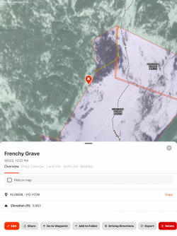
There’s coordinates for ole Frenchy. I was there in August of ‘22. I’d love to go with you guys but I’m too short to go in June. Stream crossings are over my head! Mackey
 
View attachment 129723
There’s coordinates for ole Frenchy. I was there in August of ‘22. I’d love to go with you guys but I’m too short to go in June. Stream crossings are over my head! Mackey
We could make you some stilts....
Red dot on my caltopo is where they say it is.
 
Stilts aren’t a bad idea. I’m hearing of a light snow year so maybe the runoff won’t be too bad. look forward to seeing some pictures!
Mackey
 

Attachments

  • 1708997703321.jpeg
    1708997703321.jpeg
    654.6 KB · Views: 5
You will love this area- if you haven't been up Slough its a gem! Bring a lightweight chair and some binocs and you can mozy up the trail and have a great chance of viewing bears! My favorite camp spot is 2S6 going up. Its elevated up above the meadow for a great sunset view! If you want to get outside the park there is plenty of good camp spots- a good camp spot just off the trail with a fire ring is at 45.05315, -110.15842, on the way to frenchys meadow.
If you are just looking at going up and back - on your way out an alternative route is that you can cross Slough Cr just south of the Outfitter Camp and take the tucker creek trail that will connect to Anderson Ridge Trail on the west side of Slough creek. We go in late April/May so we can stay in 2S7 or 2S8, this is before stock can use the trail so you'd need to check on that for a June trip. Coming back this way you can also see Mcbride Lake as you continue south to connect into Buffalo Fork trail to close the skinny loop! That west side route is not nearly as busy as the wagon trail(Slough Creek trail) during the summer months.
A side route to add an extra day could be Horseshoe basin/Horseshoe lake NE of Frenchys. I've heard its really nice up there. Maybe Bob or someone else has been there and has more intel. That area is on my to do list if I ever go up Slough later in the year when the snow is gone and creeks are crossable.
 
Looked at a loop once out of Lake Abundance around that area. Decided not to cause it was burned bad in 1988. And the area east by Big Mountain looks way more interesting..... LIke everything, too many places I want to visit and my time to do it gets shorter.
 
Back
Top